Related Research Articles
Pearse Island is an island in western British Columbia, Canada, in the Portland Inlet, an inlet of the Pacific Ocean. The island was first charted in 1793 by George Vancouver during his 1791-95 expedition. It was named by George Henry Richards, captain of HMS Plumper, circa 1860, in honour of William Alfred Rombulow Pearse of the Royal Navy, who had been commander of HMS Alert.
The Tsleil-Waututh Nation, formerly known as the Burrard Indian Band or Burrard Inlet Indian Band, is a First Nations band government in the Canadian province of British Columbia. The Tsleil-Waututh Nation ("TWN") are Coast Salish peoples who speak hən̓q̓əmin̓əm̓, the Downriver dialect of the Halkomelem language, and are closely related to but politically and culturally separate from the nearby nations of the Sḵwx̱wú7mesh (Squamish) and xʷməθkʷəy̓əm (Musqueam), with whose traditional territories some claims overlap.

Khutzeymateen Inlet is one of the lesser principal inlets of the British Columbia Coast. It is important in being part of the first area in Canada protected to preserve grizzly bears and their habitat via the Khutzeymateen/K’tzim-a-deen Grizzly Sanctuary. The inlet and the park-sanctuary surrounding it are between the mouths of the Skeena and Nass Rivers; the Khutzeymateen is the next inlet north from Work Channel, which is the north side of the Tsimpsean Peninsula of "Greater Prince Rupert". The inlet's mouth opens onto an arm of Portland Inlet, Steamer Passage, which lies next to Sommerville Island. The entrance to Khutzeymateen Inlet is between Keemein Point and Welgeegenk Point. The closest community is Lax Kw'alaams, formerly Port Simpson.
Loughborough Inlet is one of the lesser principal inlets of the British Columbia Coast. It penetrates the Coast Mountains on the north side of the Discovery Islands archipelago, running about 35 km (22 mi) from its head at the mouth of the Stafford River to Chancellor Channel and Cordero Channel, which are on the north side of West Thurlow Island. A further 14 km (8.7 mi) west along Chancellor Channel is Johnstone Strait.

North Bentinck Arm is a short inlet about 17 km (11 mi) in length in the Central Coast region of British Columbia, Canada. It is an arm of Burke Channel and is linked via that waterway and Labouchere Channel to Dean Channel, which is one of the largest inlets of the BC Coast.

Princess Royal Island is the largest island on the North Coast of British Columbia, Canada. It is located amongst the isolated inlets and islands east of Hecate Strait on the British Columbia Coast. At 2,251 square kilometres (869 sq mi), it is the fourth largest island in British Columbia. It was named in 1788 by Captain Charles Duncan, after his ship Princess Royal.
Green Inlet Marine Provincial Park is a provincial park in British Columbia, Canada, in the North Coast region to the southeast of Butedale and containing 33 ha.
Háthayim Marine Provincial Park, formerly Von Donop Marine Provincial Park, is a provincial park in British Columbia, Canada, located on the north end of Cortes Island in the Discovery Islands.
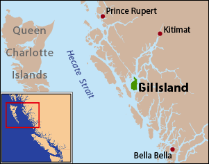
Gil Island is an island on the North Coast of British Columbia, Canada, located on the west side of Whale Channel in the entrance to Douglas Channel, one of the main coastal inlets, on the route of the Inside Passage between Pitt Island and Princess Royal Island. It is 26 km (16 mi) long, with a width ranging from 6 to 13 km, and an area of 231 km2. The only named summit on the mountainous island is Mount Gil, which faces the opening of Douglas Channel.

Masset Inlet is a large saltwater bay located in the heart of the lowland of northern Graham Island, the northernmost and largest island of the Haida Gwaii islands on the North Coast of British Columbia, Canada. It is fed by several rivers, the largest of which is the Yakoun River, and is connected to the open sea of the Dixon Entrance by the narrow Masset Sound and Masset Harbour, which opens onto McIntyre Bay. The communities of Port Clements and Sewall are located on the shores of Masset Inlet. The community of Juskatla is located on Juus Ḵáahlii, the largest of Masset Inlet's arms. There are several islands in the inlet, the largest of which is Kumdis Island, at the inlet's egress to Masset Sound and just north of Port Clements. Masset Inlet helps form the isthmus of the Naikoon Peninsula.
Cartwright Sound is a sound on the southwest coast of Graham Island in the Queen Charlotte Islands of the North Coast of British Columbia, Canada. It was named by Captain George Vancouver in honour of John Cartwright, then serving in the Royal Navy under Admiral Howe and later a noted political and social reformer in Britain. The sound is located in the area of Kano Inlet, and lies between Tcenakum and Hunter Points. In the center is a tiny island called Marble Island. Listed by the BC Geographical Names Information System, the sound is entirely missing from Google Maps. Adding to the confusion, Cartwright Sound Charters, which runs fishing expeditions to the sound, is based in Sandspit, British Columbia, on the far east coast of Graham island Queen Charlotte Islands is also now known as the Haida Gwaii archipelago
Briggs Inlet is a fjord in the North Coast region of the Canadian province of British Columbia. It lies between the Florence and Coldwell Peninsulas. It was named by H.D. Parizeau of the Hydrographic Service after Thomas S. Briggs, a former agent with the Canadian Pacific Navigation Company. It was first charted in 1793 by Spelman Swaine, one of George Vancouver's lieutenants during his 1791-95 expedition.
Roscoe Inlet is a fjord in the North Coast region of the Canadian province of British Columbia. It lies east of the Florence Peninsula, north of Johnson Channel. Its southern half was first charted in 1793 by George Vancouver and Spelman Swaine during their 1791-1795 expedition.
Cascade Inlet is a fjord in the North Coast region of the Canadian province of British Columbia. It extends northwest from Dean Channel. It was first charted in 1793 by George Vancouver and Spelman Swaine during their 1791-95 expedition. Vancouver named it "Cascade Channel" due to the great number of waterfalls he saw along its sides when he first explored the inlet.
Cousins Inlet is a fjord in the Central Coast region of the Canadian province of British Columbia. It extends north from Fisher Channel. At its head is the community of Ocean Falls. It was first charted in 1793 by George Vancouver and Spelman Swaine, during their 1791–1795 expedition to survey the Pacific Northwest.
Quottoon Inlet is an inlet in the North Coast region of the Canadian province of British Columbia. It extends northeast from Work Channel. It was first charted in 1793 by James Johnstone and Robert Barrie, two of George Vancouver’s officers during his 1791–95 expedition.

Mussel Inlet is in inlet in the North Coast region of the Canadian province of British Columbia. It is a northeast extension of Sheep Passage, and part of the Fiordland Conservancy.
Devastation Channel is a channel in the North Coast region of the Canadian province of British Columbia. It lies between Hawkesbury Island and the mainland. It was named in 1863 by Captain Daniel Pender after the H.M. paddle-sloop Devastation. It was first charted in 1793 by Joseph Whidbey, master of the Discovery during George Vancouver's 1791-95 expedition.
Ursula Channel is a channel in the North Coast region of the Canadian province of British Columbia. It separates the east coast of Gribbell Island from the mainland. It was first charted in 1793 by Joseph Whidbey, master of the Discovery during George Vancouver’s 1791-95 expedition.
Spiller Inlet is an inlet in the North Coast region of the Canadian province of British Columbia. It forms the head of Spiller Channel. It was first charted in 1793 by James Johnstone, one of George Vancouver's officers during his 1791-95 expedition.
References
- ↑ "Gilttoyees Inlet". Geographical Names Data Base . Natural Resources Canada . Retrieved 2020-06-21.
- ↑ "Gilttoyees Inlet". BC Geographical Names .
- ↑ Vancouver, George, and John Vancouver (1801). A voyage of discovery to the North Pacific ocean, and round the world. London: J. Stockdale.
{{cite book}}: CS1 maint: multiple names: authors list (link)
53°50′09″N128°58′24″W / 53.83583°N 128.97333°W
| | This article about a location on the North Coast of British Columbia, Canada is a stub. You can help Wikipedia by expanding it. |