Fræna is a municipality in Møre og Romsdal county, Norway. It is part of the region of Romsdal. The municipality is located on the Romsdal peninsula surrounding the Frænfjorden, the eastern shore of the Julsundet strait, and includes most of the Hustadvika area. It also includes the now-abandoned Bjørnsund islands.

Eide is a municipality in Møre og Romsdal county, Norway. It is part of the region of Nordmøre. It is located on the Romsdal peninsula, along the Kornstadfjorden and the Kvernesfjorden. The administrative centre of the municipality is the village of Eide. Other villages include Lyngstad, Vevang, and Visnes.
Frei is a former municipality in Møre og Romsdal county, Norway. It is located in the present-day Kristiansund Municipality between the Kvernesfjorden and Freifjorden. The municipality existed from 1838 until 2008 and upon its dissolution, it included the island of Frei and the smaller surrounding islands, totaling about 65 square kilometres (25 sq mi).

Nordmøre is a traditional district in the Norwegian county of Møre og Romsdal. The 6,059-square-kilometre (2,339 sq mi) area comprises the northern third of the county including the municipalities of Kristiansund, Averøy, Tingvoll, Surnadal, Rindal, Aure, Halsa, Eide, Sunndal, Gjemnes, and Smøla. The only city in Nordmøre is Kristiansund.

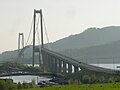
The Gjemnessund Bridge is a suspension bridge that crosses the Gjemnessundet strait between the mainland and the island of Bergsøya in the municipality of Gjemnes in Møre og Romsdal county, Norway. The 1,257-metre-long (4,124 ft) bridge was the longest suspension bridge in Norway until the opening of the Hardanger Bridge in 2013, although it did not have the longest span, being eclipsed by the Askøy Bridge.
Batnfjordsøra is the administrative centre of Gjemnes Municipality in Møre og Romsdal county, Norway. The village is located at the end of the Batnfjorden at the mouth of the river Batnfjordelva. European Route E39 passes through the village on its way from Molde to Trondheim. The 0.32-square-kilometre (79-acre) village has a population (2013) of 319, which gives the village a population density of 997 inhabitants per square kilometre (2,580/sq mi).

Kvernesfjorden or Kvernesfjord is a fjord between the municipalities of Gjemnes, Kristiansund, Averøy, and Eide in Møre og Romsdal county, Norway. The fjord is about 22 kilometres (14 mi) long.
Batnfjord or Batnfjorden is a fjord in Gjemnes Municipality in Møre og Romsdal county, Norway. The 10-kilometre (6.2 mi) long fjord begins at the village of Batnfjordsøra, the municipal center of Gjemnes Municipality, and runs to the northeast toward the island of Bergsøya, where it joins the Tingvollfjorden. Other villages on the shores of the fjord include Gjemnes, Torvikbukt, and Øre. The European route E39 highway runs along the northern shore of the fjord. The Batnfjordelva flows into this fjord.

Øre is a village and former municipality in Møre og Romsdal county, Norway. The village is located along the Batnfjorden in the present-day Gjemnes Municipality. The village lies about half-way between the villages of Batnfjordsøra and Torvikbukt. Øre Church is located in this village. The village of Øre was the administrative centre of the old Øre Municipality which existed from 1838 until 1965.

Kvernes is a village in Møre og Romsdal county, Norway. The village of Kvernes is located in the present-day Averøy Municipality on the east coast of the island of Averøya, along the Kvernesfjorden. There are two churches in Kvernes village: Kvernes Stave Church and the Kvernes Church. The stave church is now a museum.
Freifjorden is a fjord in the municipalities of Kristiansund, Tingvoll, and Gjemnes in Møre og Romsdal county, Norway. The 14-kilometre (8.7 mi) long fjord begins near the island of Tustna and flows southwest between the islands of Nordlandet and Frei on the west side and the mainland peninsula of Straumsnes and the islands of Aspøya and Bergsøya on the east side. The Kvernesfjorden lies at the west end of the Freifjorden, near the Freifjord Tunnel. The villages of Nedre Frei and Kvalvåg are located on the western shore of the fjord.
The Freifjord Tunnel is a 5,086-metre (3.2 mi) long undersea tunnel under the Freifjorden in Møre og Romsdal county, Norway. The tunnel is part of the Norwegian National Road 70. The tunnel begins on the island of Frei in Kristiansund Municipality and then descends 130 metres (430 ft) below the Freifjorden and ends on the island of Bergsøya in Gjemnes Municipality. The tunnel opened in 1992 as part of the Krifast system which connects the city of Kristiansund to the mainland of Norway through this tunnel and then across either the Bergsøysund Bridge or the Gjemnessund Bridge from Bergsøya.

Bergsøya is an island in Gjemnes Municipality in Møre og Romsdal county, Norway. The island is located near the junctions of the Freifjorden, Kvernesfjorden, and Tingvollfjorden. The highest point on the 8.7-square-kilometre (3.4 sq mi) island is the 278-metre (912 ft) tall mountain Varden.

Tingvollvågen or Tingvoll is the administrative centre of Tingvoll Municipality in Møre og Romsdal county, Norway. The village is located on a small inlet off the Tingvollfjorden, directly across the fjord from the village of Angvika. Tingvollvågen lies about 10 kilometres (6.2 mi) north of Meisingset and about 20 kilometres (12 mi) south of Straumsnes. The historic Tingvoll Church is located in this village. Norwegian National Road 70 runs through the village on its way from Kristiansund to Oppdal.
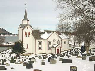
Øre Church is a parish church in Gjemnes Municipality in Møre og Romsdal county, Norway. It is located in the village of Øre. The church is part of the Øre parish in the Indre Nordmøre deanery in the Diocese of Møre. The white, wooden church was built in 1865 by the architect Gustav Olsen. The church seats about 330 people.
Røbekk is a village in Molde Municipality in Møre og Romsdal county, Norway. The village is located on the northern shore of the Fannefjorden, about 7 kilometres (4.3 mi) east of the town of Molde. The Årø neighborhood lies immediately to the west of Røbekk. The European route E39 highway runs through the village on its way from the town of Molde towards Batnfjordsøra in Gjemnes Municipality. Røbekk Church has been located in this village since 1898.