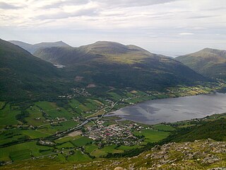
Fræna is a municipality in Møre og Romsdal county, Norway. It is part of the region of Romsdal. The municipality is located on the Romsdal peninsula surrounding the Frænfjorden, the eastern shore of the Julsundet strait, and includes most of the Hustadvika area. It also includes the now-abandoned Bjørnsund islands.

Eide is a municipality in Møre og Romsdal county, Norway. It is part of the region of Nordmøre. It is located on the Romsdal peninsula, along the Kornstadfjorden and the Kvernesfjorden. The administrative centre of the municipality is the village of Eide. Other villages include Lyngstad, Vevang, and Visnes.

Gjemnes is a municipality in Møre og Romsdal county, Norway on the Romsdal peninsula. It is part of the Nordmøre region. The administrative centre is the village of Batnfjordsøra, which lies along the Batnfjorden and it is a former steamship landing place. Other villages in Gjemnes include Torvikbukt, Flemma, Angvika, Gjemnes, Øre, and Osmarka.

Angvik or Angvika is a small village in Gjemnes Municipality in Møre og Romsdal county, Norway. The village is located along the western shores of the Tingvollfjorden, just across the fjord from the village of Tingvollvågen.

Nordmøre is a traditional district in the Norwegian county of Møre og Romsdal. The 5,426-square-kilometre (2,095 sq mi) area comprises the northern third of the county including the municipalities of Kristiansund, Averøy, Tingvoll, Surnadal, Aure, Halsa, Eide, Sunndal, Gjemnes, and Smøla. The only town in Nordmøre is Kristiansund
Torvikbukt is a village in Gjemnes Municipality in Møre og Romsdal county, Norway. The village is located at the junction of the Batnfjorden and Tingvollfjorden and just northwest of the 994-metre (3,261 ft) tall mountain Reinsfjellet. The village of Øre lies about 6 kilometres (3.7 mi) to the southwest and Heggem lies about 9 kilometres (5.6 mi) to the south. The 0.39-square-kilometre (96-acre) village has a population (2013) of 226, which gives the village a population density of 579 inhabitants per square kilometre (1,500/sq mi).
Batnfjordsøra is the administrative centre of Gjemnes Municipality in Møre og Romsdal county, Norway. The village is located at the end of the Batnfjorden at the mouth of the river Batnfjordelva. European Route E39 passes through the village on its way from Molde to Trondheim. The 0.32-square-kilometre (79-acre) village has a population (2013) of 319, which gives the village a population density of 997 inhabitants per square kilometre (2,580/sq mi).

Raudsand or Rausand is a village in Nesset Municipality in Møre og Romsdal county, Norway. It is located on the Romsdal peninsula along the Tingvollfjorden about 9 kilometres (5.6 mi) northeast of the village of Eidsvåg and 8 kilometres (5.0 mi) south of the village of Angvika in Gjemnes Municipality. The 0.45-square-kilometre (110-acre) village has a population (2013) of 277, which gives the village a population density of 616 inhabitants per square kilometre (1,600/sq mi).

Sunndalsøra (help·info) is the administrative centre of Sunndal Municipality in Møre og Romsdal county, Norway. The village of Sunndalsøra lies at the mouth of the river Driva at the beginning of the Sunndalsfjorden. Sunndalsøra is surrounded by steep mountains, such as Hårstadnebba, which reach elevations as high as 1,700 metres (5,600 ft). Some of these mountains around Sunndalsøra are used for BASE jumping.

Kvernesfjorden or Kvernesfjord is a fjord between the municipalities of Gjemnes, Kristiansund, Averøy, and Eide in Møre og Romsdal county, Norway. The fjord is about 22 kilometres (14 mi) long.
Batnfjord or Batnfjorden is a fjord in Gjemnes Municipality in Møre og Romsdal county, Norway. The 10-kilometre (6.2 mi) long fjord begins at the village of Batnfjordsøra, the municipal center of Gjemnes Municipality, and runs to the northeast toward the island of Bergsøya, where it joins the Tingvollfjorden. Other villages on the shores of the fjord include Gjemnes, Torvikbukt, and Øre. The European route E39 highway runs along the northern shore of the fjord. The Batnfjordelva flows into this fjord.
Karitinden is a mountain in the Tafjordfjella mountain range inside Reinheimen National Park on the border of Møre og Romsdal and Oppland counties in Norway. The top of the mountain is a tripoint border junction for Skjåk Municipality, and Norddal Municipality and Rauma Municipality. The nearest village is Tafjord which lies 17 kilometres (11 mi) to the northwest. The lake Tordsvatnet lies 4 kilometres (2.5 mi) southeast of the mountain and the mountain Puttegga lies 4 kilometres (2.5 mi) to the northwest.
Kyrkjetaket or Kirketaket is a mountain on the border of the municipalities of Rauma and Nesset in Møre og Romsdal county, Norway. The peak is located in Rauma, about 7 kilometres (4.3 mi) northeast of the village of Isfjorden and 12.4 kilometres (7.7 mi) from Åndalsnes. The mountain Gjuratinden lies about 9 kilometres (5.6 mi) southeast of Kyrkjetaket. The name Kyrkjetaket translates to "the Church roof".

Hornindalsrokken is a 1,529-metre (5,016 ft) tall mountain in Norway. It is located on the border of three municipalities in two different counties: Stranda Municipality and Ørsta Municipality in Møre og Romsdal county and Hornindal Municipality in Sogn og Fjordane county. The mountain is sometimes also called Honndalsrokken or sometimes just Rokken or Rokkjen.

Bergsøya is an island in Gjemnes Municipality in Møre og Romsdal county, Norway. The island is located near the junctions of the Freifjorden, Kvernesfjorden, and Tingvollfjorden. The highest point on the 8.7-square-kilometre (3.4 sq mi) island is the 278-metre (912 ft) tall mountain Varden.

Heggem is a village in Gjemnes Municipality in Møre og Romsdal county, Norway. The village is located about 8 kilometres (5.0 mi) south of Torvikbukt and about 8 kilometres (5.0 mi) west of Angvik. The Osmarka Chapel is located here. The village has a good view of the mountain Reinsfjellet, located to the northeast.

Flemma is a village in Gjemnes Municipality in Møre og Romsdal county, Norway. The village lies along the Tingvollfjorden, about 6 kilometres (3.7 mi) north of the village of Angvika. The mountain Reinsfjellet lies about 7 kilometres (4.3 mi) to the west. Across the fjord from Flemma is the village of Gyl in Tingvoll Municipality.
Gjemnes is a village in Gjemnes Municipality in Møre og Romsdal county, Norway. The village is located on the southern part of a small peninsula surrounded by the Kvernesfjorden to the north and the Batnfjorden to the south. The village sits along the European route E39 at the western end of the Gjemnessund Bridge (which is part of the network of bridges and tunnels that connect the town of Kristiansund to the mainland. The municipal centre of Batnfjordsøra lies about 8 kilometres to the southwest, at the end of the fjord.

Tingvollvågen or Tingvoll is the administrative centre of Tingvoll Municipality in Møre og Romsdal county, Norway. The village is located on a small inlet off the Tingvollfjorden, directly across the fjord from the village of Angvika. Tingvollvågen lies about 10 kilometres (6.2 mi) north of Meisingset and about 20 kilometres (12 mi) south of Straumsnes. The historic Tingvoll Church is located in this village. Norwegian National Road 70 runs through the village on its way from Kristiansund to Oppdal.
Røbekk is a village in Molde Municipality in Møre og Romsdal county, Norway. The village is located on the northern shore of the Fannefjorden, about 7 kilometres (4.3 mi) east of the town of Molde. The Årø neighborhood lies immediately to the west of Røbekk. The European route E39 highway runs through the village on its way from the town of Molde towards Batnfjordsøra in Gjemnes Municipality. Røbekk Church has been located in this village since 1898.