
Rindal is a municipality in Trøndelag county, Norway. It is part of the Orkdalen region. The administrative centre is the village of Rindal. Other villages in the municipality include Tiset and Romundstad. The municipality centres on agriculture and forestry services.

Evenes is a municipality in Nordland county, Norway. It is part of the traditional district of Ofoten. The administrative centre of the municipality is the village of Bogen. Other villages in Evenes include Liland, Tårstad, Dragvik, and the village of Evenes.

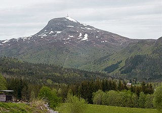
Angvik or Angvika is a small village in Gjemnes Municipality in Møre og Romsdal county, Norway. The village is located along the western shores of the Tingvollfjorden, just across the fjord from the village of Tingvollvågen.

Baugevatnet is a lake that lies in Tysfjord Municipality in Nordland county, Norway. The 4.99-square-kilometre (1.93 sq mi) lake is located about 25 kilometres (16 mi) east of the village of Kjøpsvik and just 1.5 kilometres (0.93 mi) northwest of the border with Sweden. The lake Båvrojávrre lies about 3 kilometres (1.9 mi) to the southwest and the lake Langvatnet lies about the same distance to the north.

Bolagen is a lake in the municipality of Røros in Trøndelag county, Norway. The 2.5-square-kilometre (0.97 sq mi) lake is located about 4.5 kilometres (2.8 mi) southeast of the village of Brekken and about 4 kilometres (2.5 mi) west of the border with Sweden. The large lake Aursunden lies about 4 kilometres (2.5 mi) to the west of Bolagen.
Sørungen is a lake in the municipality of Selbu in Trøndelag county, Norway. The 7.24-square-kilometre (2.80 sq mi) lake is located about 8 kilometres (5.0 mi) south of the village of Vikvarvet, about 18 kilometres (11 mi) west of the village of Flora, and about 10 kilometres (6.2 mi) northeast of the lake Samsjøen in the neighboring municipality of Midtre Gauldal.
Malmsjøen is a lake in the municipality of Skaun in Trøndelag county, Norway. It is located about 1.5 kilometres (0.93 mi) southeast of the village of Skaun, about 7 kilometres (4.3 mi) north of the village of Korsvegen, and about 10 kilometres (6.2 mi) southwest of the village of Melhus. The Norwegian County Road 709 runs along the northern shore of the lake.
Øvre Tysdalsvatnet is a lake in the municipality of Hjelmeland in Rogaland county, Norway. The 9-square-kilometre (3.5 sq mi) lake lies on the east side of the village of Årdal. The 12-kilometre (7.5 mi) long lake is only about 800 metres (0.5 mi) wide and it has a fairly steep shoreline, which results in very little habitation around the lake.

Gyvatn is a lake in Norway. The lake straddles the borders of the three municipalities of Bygland and Evje og Hornnes and Åseral. The 4.62-square-kilometre (1.78 sq mi) lake is located about 8 kilometres (5.0 mi) northwest of the village of Byglandsfjord and the lake Byglandsfjorden and it is about 7 kilometres (4.3 mi) east of the village of Åknes in Åseral.
Byavatnet is a lake in the municipality of Levanger in Trøndelag county, Norway. It is located about 2.5 kilometres (1.6 mi) south of the village of Ekne and about 3 kilometres (1.9 mi) west of the village of Ronglan. The lake Hammervatnet lies about 3.5 kilometres (2.2 mi) south of Byavatnet and the lake Sønningen lies about 1.5 kilometres (0.93 mi) to the northwest. The 2.31-square-kilometre (570-acre) lake is about 5 kilometres (3.1 mi) long and about 800 metres (0.5 mi) wide.
Gilten is a lake in the municipality of Steinkjer in Trøndelag county, Norway. The 31.62-square-kilometre (12.21 sq mi) lake lies in the northern part of Steinkjer, about 8 kilometres (5.0 mi) northeast of the village of Kvam, about 1.5 kilometres (0.93 mi) north of the village of Følling, and about 14 kilometres (8.7 mi) east of the village of Namdalseid. The lake is only accessible by road from Namdalseid, even though most of the 31.62-square-kilometre (12.21 sq mi) lake lies in Steinkjer. The lake Bangsjøan lies to the northeast and the lake Snåsavatnet lies to the south.
Holden is a lake in the municipality of Verran in Trøndelag county, Norway. It is located about 8 kilometres (5.0 mi) west of the village of Malm and about 10 kilometres (6.2 mi) north of the village of Follafoss. The 13.31-square-kilometre (5.14 sq mi) lake has a dam on the southern end to control the water for hydroelectric power. The lake flows out into the Follaelva river which flows into the Trondheimsfjord at the village of Follafoss.
Storvatnet (Norwegian) or Ránujávri (Northern Sami) is a lake in the municipality of Ballangen in Nordland county, Norway. The 9.76-square-kilometre (3.77 sq mi) lake is located about 8 kilometres (5.0 mi) east of the village of Ballangen.

Oppstrynsvatn is a lake in the municipality of Stryn in Sogn og Fjordane county, Norway. It is located about 8 kilometres (5.0 mi) east of the village of Stryn. The villages of Flo, Oppstryn, and Erdal are located on the shores of the lake.

Dingevatn or Dingevatnet is the 18th deepest lake in Norway, reaching a maximum depth of 220 metres (720 ft). It is located in the municipality of Gulen in Sogn og Fjordane county. The 2.84-square-kilometre (1.10 sq mi) lake is located just east of the village of Dingja, about 1 kilometre (0.62 mi) southeast of the mouth of the Sognefjorden. The lake lies about 4 kilometres (2.5 mi) north of the municipal center of Eivindvik. The lake flows out into the small Dingjaelva river, which runs past the village of Dingja before emptying into the Sognesjøen strait.
Endestadvatnet is a lake in the municipality of Flora in Sogn og Fjordane county, Norway. The lake is located about 8 kilometres (5.0 mi) east of the village of Eikefjord and 5 kilometres (3.1 mi) west of the lake Emhjellevatnet in neighboring Gloppen municipality.

Hommelvik is the administrative centre of the municipality of Malvik in Trøndelag county, Norway. The village is located at the end of the Hommelvika, a bay off of the Trondheimsfjord. Hommelvik is about 2.5 kilometres (1.6 mi) southwest of the village of Muruvika, about 4 kilometres (2.5 mi) southeast of the village of Smiskaret, about 8 kilometres (5.0 mi) east of the village of Vikhammer, and about 10 kilometres (6.2 mi) north of the village of Sneisen. The river Homla runs north through the village, emptying into the fjord. The name of the village is derived from the river name.
Reinsfjellet is a mountain in Gjemnes Municipality in Møre og Romsdal county, Norway. The 994-metre (3,261 ft) tall mountain is the third tallest mountain in the municipality. It is located on the Romsdal peninsula about 4 kilometres (2.5 mi) southeast of the village of Torvikbukt and the Batnfjorden. The village of Heggem lies 6.5 kilometres (4.0 mi) to the southwest and Angvika lies 10 kilometres (6.2 mi) to the southeast.

Sparbu is a village in the municipality of Steinkjer in Trøndelag county, Norway. The village is located about 12 kilometres (7.5 mi) south of the town of Steinkjer. The European route E6 highway runs through the village as does the Nordlandsbanen railway line which stops at the Sparbu Station. The village of Mære lies about 2 kilometres (1.2 mi) to the north, the village of Røra lies about 8 kilometres (5.0 mi) to the south, and the lake Leksdalsvatnet lies about 8 kilometres (5.0 mi) to the east.


