Gjemnes is a municipality in Møre og Romsdal county, Norway on the Romsdal peninsula. It is part of the Nordmøre region. The administrative centre is the village of Batnfjordsøra, which lies along the Batnfjorden and it is a former steamship landing place. Other villages in Gjemnes include Torvikbukt, Flemma, Angvika, Gjemnes, Øre, and Osmarka.

Straumgjerde is a village in Sykkylven Municipality in Møre og Romsdal county, Norway. The village is located where the lake Fitjavatnet empties into the Sykkylvsfjorden. It is about 6 kilometres (3.7 mi) south of the municipal center of Aure and about 11 kilometres (6.8 mi) south of Ikornnes. The mountain Råna lies 6 kilometres (3.7 mi) south of the village.

Elsvatnet (Norwegian) or Aalesjaevrie (Southern Sami) is a lake in the municipality of Hattfjelldal in Nordland county, Norway. It lies about 6 kilometres (3.7 mi) east of the village of Hattfjelldal, about half-way between the lakes Røssvatnet and Unkervatnet.

Rien is a lake in the municipality of Røros in Trøndelag county, Norway. The 14.87-square-kilometre (5.74 sq mi) lake is located near the headwaters of the river Glomma, only about 10 kilometres (6.2 mi) east of the border with Sweden. The water flows out through the river Glomma and heads a short distance south, into the large lake Aursunden. The village of Brekken lies about 6 kilometres (3.7 mi) south of the lake and the town of Røros lies about 40 kilometres (25 mi) to the southwest.
Gagnåsvatnet or Gangåsvatnet is a lake in the municipality of Orkdal in Trøndelag county, Norway. The 5.49-square-kilometre (1,360-acre) lake is located about 9 kilometres (5.6 mi) southwest of the town of Orkanger and about 6 kilometres (3.7 mi) west of the village of Fannrem in the Orkdalen valley.

Svorksjøen is a lake in Trøndelag county, Norway. The 3.55-square-kilometre (1.37 sq mi) lake lies on the border of the municipalities of Melhus, Meldal, and Orkdal. The lake lies about 6 kilometres (3.7 mi) east of the village of Svorkmo in Orkdal and about 10 kilometres (6.2 mi) southwest of the village of Korsvegen in Melhus.

Ormsavatnet is a lake in the municipality of Bykle in Aust-Agder county, Norway. The 3.11-square-kilometre (1.20 sq mi) lake flows into the Vatndalsvatnet via a dam and canal. The lake is located in the Setesdalsheiene mountains near the lakes Store Urevatn, Holmevatnet, and Hartevatnet. The nearest village area is Hovden, about 14 kilometres (8.7 mi) to the northeast. The mountain Kaldafjellet lies about 5 kilometres (3.1 mi) to the west of the lake.
Holmevatnet or Holmevatn is a lake in the Setesdalsheiene area of Norway. It is located in the mountains on the border of the municipalities of Bykle in Aust-Agder county and Suldal in Rogaland county. The 4.76-square-kilometre (1.84 sq mi) lake lies just west of the lake Store Urevatn and to the northeast of the lake Blåsjø. The nearest villages are Berdalen in Bykle, about 20 kilometres (12 mi) to the east and Suldalsosen, about 30 kilometres (19 mi) to the west. The mountain Kaldafjellet lies about 6 kilometres (3.7 mi) north of the lake.

Sæbø is a village in Ørsta Municipality in Møre og Romsdal county, Norway. The village is located along the Hjørundfjorden in the Bondalen valley. It is about 5 kilometres (3.1 mi) north of the mountain Skårasalen. The village of Store-Standal lies about 6 kilometres (3.7 mi) to the north and the villages of Leira and Bjørke lie about 11 kilometres (6.8 mi) to the south.

Holsavatnet is a lake which lies in the municipality of Førde in Sogn og Fjordane county, Norway. The lake is located about 12 kilometres (7.5 mi) east of the town of Førde and about 9.5 kilometres (5.9 mi) east of the village of Bruland. The village of Holsen lies at the eastern end of the lake. The European route E39 highway passes 3 kilometres (1.9 mi) west of the lake. The lake eventually flows into the river Jølstra.

Havvannet (Norwegian) or Vuolit Áhpelanjávri is a lake in Måsøy Municipality in Finnmark county, Norway. The 3.69 square kilometres (1.42 sq mi) lake lies isolated in the mountains on the Porsanger Peninsula about 9 kilometres (5.6 mi) northeast of the village of Kokelv in Kvalsund Municipality. The lake sits at an elevation of 293-metre (961 ft) above sea level. The village of Slåtten lies about 14 kilometres (8.7 mi) northwest of the lake.

Lovatnet is a lake in the municipality of Stryn in Sogn og Fjordane county, Norway. It is located about 2 kilometres (1.2 mi) southeast of the village of Loen and about 6 kilometres (3.7 mi) east of the village of Olden. The lake lies just 2 kilometres (1.2 mi) southwest of the mountain Skåla. The water from the lake flows down from the mountains; especially from the Jostedalsbreen and Tindefjellbreen glaciers. It then flows out through the Loelva river into the Nordfjorden.

Hornindalsrokken is a 1,529-metre (5,016 ft) tall mountain in Norway. It is located on the border of three municipalities in two different counties: Stranda Municipality and Ørsta Municipality in Møre og Romsdal county and Hornindal Municipality in Sogn og Fjordane county. The mountain is sometimes also called Honndalsrokken or sometimes just Rokken or Rokkjen.
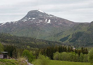
Reinsfjellet is a mountain in Gjemnes Municipality in Møre og Romsdal county, Norway. The 994-metre (3,261 ft) tall mountain is the third tallest mountain in the municipality. It is located on the Romsdal peninsula about 4 kilometres (2.5 mi) southeast of the village of Torvikbukt and the Batnfjorden. The village of Heggem lies 6.5 kilometres (4.0 mi) to the southwest and Angvika lies 10 kilometres (6.2 mi) to the southeast.

Lysvatnet (Norwegian) or Čáhppesjávri (Northern Sami) is a lake in Lenvik Municipality in Troms county, Norway. The lake lies in the Helvetesdalen valley on the island of Senja. The 6-kilometre (3.7 mi) long lake covers an area of 3.67 square kilometres (1.42 sq mi). The lake lies about 10 kilometres (6.2 mi) west of the village of Gibostad.

Heggem is a village in Gjemnes Municipality in Møre og Romsdal county, Norway. The village is located about 8 kilometres (5.0 mi) south of Torvikbukt and about 8 kilometres (5.0 mi) west of Angvik. The Osmarka Chapel is located here. The village has a good view of the mountain Reinsfjellet, located to the northeast.

Flemma is a village in Gjemnes Municipality in Møre og Romsdal county, Norway. The village lies along the Tingvollfjorden, about 6 kilometres (3.7 mi) north of the village of Angvika. The mountain Reinsfjellet lies about 7 kilometres (4.3 mi) to the west. Across the fjord from Flemma is the village of Gyl in Tingvoll Municipality.
Eimhjellevatnet or Emhjellevatnet is a lake in Hyen area of Gloppen Municipality in Sogn og Fjordane county, Norway. The 11.39-square-kilometre (4.40 sq mi) lake is located in the western part of the municipality near the border with Flora Municipality. The villages of Eimhjellen and Solheim can be found along its shore and the village of Straume lies about 15 kilometres (9.3 mi) to the north. The lake lies about 25 kilometres (16 mi) southwest of the municipal center of Sandane. It is the second largest lake in all of Gloppen municipality and it has a good population of trout for fishing.

Tingvollvågen or Tingvoll is the administrative centre of Tingvoll Municipality in Møre og Romsdal county, Norway. The village is located on a small inlet off the Tingvollfjorden, directly across the fjord from the village of Angvika. Tingvollvågen lies about 10 kilometres (6.2 mi) north of Meisingset and about 20 kilometres (12 mi) south of Straumsnes. The historic Tingvoll Church is located in this village. Norwegian National Road 70 runs through the village on its way from Kristiansund to Oppdal.