Related Research Articles

Blackall is a rural town and locality in the Blackall-Tambo Region, Queensland, Australia. In the 2016 census the locality of Blackall had a population of 1,416 people.
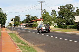
Tambo is a rural town and locality in the Blackall-Tambo Region, Queensland, Australia. Cattle and tourism are the major industries of the town. A number of heritage buildings survive from the earliest days of settlement.

The Regions of Queensland refer to the geographic areas of the Australian state of Queensland. Due to its large size and decentralised population, the state is often divided into regions for statistical and administrative purposes. Each region varies somewhat in terms of its economy, population, climate, geography, flora and fauna. Cultural and official perceptions and definitions of the various regions differ somewhat depending on the government agency or popular group by which they are being applied.
The Shire of Tambo was a local government area located in central Queensland south-east of the town of Blackall. It covered an area of 14,083.8 square kilometres (5,437.8 sq mi), and existed as a local government entity from 1881 until 2008, when it amalgamated with neighbouring Shire of Blackall to form the Blackall-Tambo Region.

The Shire of Blackall was a local government area located in central Queensland around the town of Blackall. It covered an area of 16,366.8 square kilometres (6,319.3 sq mi), and existed as a local government entity from 1879 until 2008, when it amalgamated with neighbouring Shire of Tambo to form the Blackall-Tambo Region.

Lands administrative divisions of Queensland refers to the divisions of Queensland used for the registration of land titles. There are 322 counties, and 5,319 parishes within the state. They are part of the Lands administrative divisions of Australia. Queensland had been divided into 109 counties in the nineteenth century, before the Land Act of 1897 subdivided many of these counties to 319. Some of the eastern counties remained the same, with most of the subdivisions occurring in the west and north. The current counties were named and bounded by the Governor in Council on 7 March 1901.

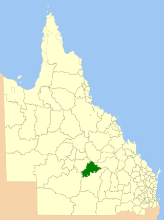
The Blackall-Tambo Region is a local government area in Central West Queensland, Australia. Established in 2008, it was preceded by two previous local government areas dating from the 1870s.

Central West Queensland is a remote region in the Australian state of Queensland which covers 396,650.2 km2. The region lies to the north of South West Queensland and south of the Gulf Country. It has a population of approximately 12,387 people. As of 2018, it is one of 16 Aged Care Planning Regions (ACPR) in Queensland.
The Town of Blackall was a local government area located in central Queensland, for the purposes of governing the town of Blackall. It exists from 1880 to 1931.

Witta is a rural town and locality in the Sunshine Coast Region, Queensland, Australia. In the 2021 census, the locality of Witta had a population of 1,296 people.

Tambo Post Office is a heritage-listed former post office and now museum at Arthur Street, Tambo, Blackall-Tambo Region, Queensland, Australia. It was built in 1876 and 1885. It is also known as Post and Telegraph Office Tambo and Tambo Telecommunications Museum. It was added to the Queensland Heritage Register on 21 October 1992.
Yalleroi is a rural town in the north of the locality of Blackall in the Blackall-Tambo Region, Queensland, Australia.
Caldervale is a rural locality in the Blackall-Tambo Region, Queensland, Australia. In the 2021 census, Caldervale had a population of 16 people.
Burrandilla County is a cadastral division of Queensland and a County of the Warrego Land District of south western Queensland. The county is divided into civil parishes.
Palmer County is a cadastral division of Queensland and a County of the Warrego Land District of southwestern Queensland.

Durrie County Queensland is a cadastral division of Warrego Land District of Southern Queensland and a County of Queensland, Australia. The county is divided into civil parishes.
Weramo County Queensland is a cadastral division of Warrego Land District of western Queensland aa locality and a County of Queensland, Australia. Weramo County is in the arid centre of the continent.

County of Kungie is one of the 318 counties of Queensland, Australia. The county is divided into civil parishes. It is within the Darling Downs region west Brisbane.
Blackall–Jericho Road is a continuous 121-kilometre (75 mi) road route in the Blackall-Tambo and Barcaldine local government areas of Queensland, Australia. It is a state-controlled regional road, rated as a local road of regional significance (LRRS).
Isisford–Blackall Road is a continuous 122-kilometre (76 mi) road route in the Longreach and Blackall-Tambo local government areas of Queensland, Australia. It is a state-controlled regional road, rated as a local road of regional significance (LRRS).
References
- ↑ "Glanworth – county in the Blackall-Tambo Region (entry 13882)". Queensland Place Names. Queensland Government . Retrieved 4 April 2024.
- ↑ Glanworth, Queensland.
- ↑ Glanworth, Queensland, ozexplorer.com
- ↑ Queensland showing counties / compiled and published at the Survey Department, Brisbane, Brisbane : Survey Dept., 1900.
- ↑ "Locality boundaries - Queensland". Department of Natural Resources, Mines and Energy. 27 August 2017. Archived from the original on 31 March 2018. Retrieved 2 October 2018.