
The River Usk rises on the northern slopes of the Black Mountain, Wales, in the westernmost part of the Brecon Beacons National Park. Initially forming the boundary between Carmarthenshire and Powys, it flows north into Usk Reservoir, then east by Sennybridge to Brecon before turning southeast to flow by Talybont-on-Usk, Crickhowell and Abergavenny, after which it takes a more southerly course.

The Taff Trail is a walking and cycle path that runs for 55 miles (89 km) between Cardiff Bay and Brecon in Wales. It is so named because it follows the course of the River Taff. Along much of its length, it follows the National Cycle Network Route 8 that continues to Holyhead, and is substantially off-road.

The Brecon Mountain Railway is a 1 ft 11+3⁄4 in narrow gauge tourist railway on the south side of the Brecon Beacons. It climbs northwards from Pant along the full length of the Pontsticill Reservoir and continues past the adjoining Pentwyn Reservoir to Torpantau railway station. The railway's starting point at Pant is located two miles (3 km) north of the town centre of Merthyr Tydfil, Merthyr Tydfil County Borough, South-East Wales.
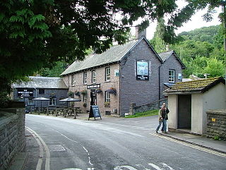
Talybont-on-Usk is a village and community in Powys, Wales, in the historic county of Brecknockshire. It lies on both the Caerfanell river and the Monmouthshire and Brecon Canal, about 1 mile (1.6 km) from the River Usk. In 2001, it had a population of 743, reducing to 719 at the 2011 census. The community includes the settlements of Llansantffraed, Scethrog, Aber Village, and Pencelli.
The Usk Reservoir is located in the upper Usk Valley, at 1,006 feet (307 m) above sea level, in the western part of the Brecon Beacons National Park, Wales. The county boundary between Carmarthenshire and Powys runs through the reservoir which lies about six miles to the north of the Black Mountain escarpment. It is an important landmark for walkers on the mountain range.

Penwyllt is a hamlet located in the upper Swansea Valley in Wales. It lies within a part of the Brecon Beacons National Park in the traditional county of Brecknockshire; currently administered as part of the unitary authority of Powys.
The Clydach Gorge is a steep-sided valley in south-east Wales down which the River Clydach flows to the River Usk. It runs for 5.6 kilometres (3.5 mi) from the vicinity of Brynmawr in Blaenau Gwent eastwards and northeastwards to Gilwern in Monmouthshire. The Gorge was one of the first locations in the region to be industrialised though it still retains its natural environment. It has long been an important transport corridor between Abergavenny and the lowlands of Monmouthshire and the northeastern quarter of the South Wales Coalfield. It is now exploited by the A465 Heads of the Valleys trunk road which runs between Abergavenny and Swansea and which serves the Heads of the Valleys sub-region.

Fan Fawr is a mountain in the Fforest Fawr section of the Brecon Beacons National Park, in Powys, Wales and over 734 m (2,408 ft) high.

Fforest Fawr is an extensive upland area in the county of Powys, Wales. Formerly known as the Great Forest of Brecknock in English, it was a royal hunting area for several centuries but is now used primarily for sheep grazing, forestry, water catchment and recreation. It lies within the Brecon Beacons National Park.
The Afon Llia is a short river in Powys, Wales, and which is wholly contained within the Brecon Beacons National Park.

The Afon Crai is a river in Powys, Wales rising in the Fforest Fawr section of the Brecon Beacons National Park and flowing north into the River Usk. The headwaters known as Blaen-crai flow north from Bwlch Bryn-rhudd, a col between the Crai valley and the upper Swansea Valley for 2 km into the Cray Reservoir. The river emerges from below the dam to flow a further 8 km through the dispersed settlement of Crai.

The Afon Senni is a river in Powys, Wales which rises in the Fforest Fawr section of the Brecon Beacons National Park and flows northwards for 11 kilometres (7 mi) to a confluence with the River Usk at Sennybridge.

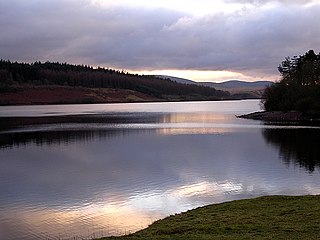
The Caerfanell is a river which rises in the central section of the Brecon Beacons National Park in Powys, Wales. It rises as Blaen Caerfanell on the plateau of Gwaun Cerrig Llwydion and drops steeply down south-eastwards into the head of Glyn Collwn before turning east then north-east into Talybont Reservoir. It emerges from the hydro turbine beneath the dam just above the village of Aber and continues northwards to its confluence with the River Usk at the hamlet of Llansantffraed.

Tor y Foel is a hill in the Brecon Beacons National Park in the county of Powys in Wales. It is located on the eastern flank of Talybont Reservoir, and the summit at 551m is marked by a small cairn. It gives excellent panoramic views over the valley of the River Usk, across to the Black Mountains and west to the Brecon Beacons.

The Grwyne Fawr is a river in the Brecon Beacons National Park in south Wales. A section of it forms the administrative border between Powys and Monmouthshire and also of the historic counties of Brecon and Monmouth. The river and its major tributary the Grwyne Fechan flow into the River Usk at Glangrwyney.

Allt yr Esgair is a hill in the Brecon Beacons National Park in Powys, Wales. It is commonly referred to locally as simply 'The Allt'. The Welsh name signifies 'wooded slope of the ridge'. It takes the form of a northwest-southeast aligned ridge which rises to a height of 393m and which overlooks the valley of the River Usk to the west and south. To the northeast are panoramic views across Llangorse Lake to the Black Mountains There is a viewfinder on the summit erected as a monument to Eirene Lloyd White, Baroness White of Rhymney. It is a Marilyn with a prominence of 199 metres.

Mynydd Myddfai is a hill 4.5 miles southeast of Llandovery in the county of Carmarthenshire, southwest Wales. It lies within the Brecon Beacons National Park and Fforest Fawr Geopark. The hill is in the form of a broad ridge aligned southwest to northeast with three or four distinct tops separated by cols. The northwest side drops steeply away towards the village of Myddfai whilst the other side is a more shallow slope down towards Glasfynydd Forest which encircles Usk Reservoir. The plateau surface of the hill rises to a height of 440m at OS grid ref SN 806297 where a trig point has been erected.

Llanfrynach is a village and community in the county of Powys, Wales, and the historic county of Brecknockshire. The population of the community as taken at the 2011 census was 571. It lies just to the southeast of Brecon in the Brecon Beacons National Park. The village sits astride the Nant Menasgin, a right bank tributary of the River Usk. The B4558 passes just to its north and the Monmouthshire and Brecon Canal also passes around the village. The Welsh name signifies the 'church of Brynach'. The community includes the hamlets of Llanhamlach and Groesffordd.

Pen-y-crug is a hill in the Brecon Beacons National Park in the county of Powys, south Wales. It is commonly referred to locally as simply 'The Crug'. The Welsh name signifies 'top of the mound'. It slopes are moderately gently on three sides; only to the west do they steepen somewhat. Its flat trig point adorned summit at 331m overlooks the valley of the River Usk to the south. To the southeast are panoramic views over Brecon whilst eastwards are the Black Mountains and south the Brecon Beacons.

The Usk Bridge in Brecon, Powys, Wales is the town's oldest route over the River Usk. It carries the B4601 road, formerly the A40, between Brecon and Llanfaes.
