
Lanarkshire, also called the County of Lanark, is a historic county, lieutenancy area and registration county in the Central Lowlands and Southern Uplands of Scotland. The county is no longer used for local government purposes, but gives its name to the two modern council areas of North Lanarkshire and South Lanarkshire.

The Argyle Line is a suburban railway located in West Central Scotland. The line serves the commercial and shopping districts of Glasgow's central area, and connects towns from West Dunbartonshire to South Lanarkshire. Named for Glasgow's Argyle Street, the line uses the earlier cut-and-cover tunnel running beneath that thoroughfare.

The SEC Centre is Scotland's largest exhibition centre, located in Glasgow, Scotland. It is one of the three main venues within the Scottish Event Campus.

The Clyde Tunnel is a crossing beneath the River Clyde in Glasgow, Scotland for road traffic, cyclists and pedestrians. Two parallel tunnel tubes connect the districts of Whiteinch to the north and Govan to the south in the west of the city.

The Finnieston Crane or Stobcross Crane is a disused giant cantilever crane in the centre of Glasgow, Scotland. It is no longer operational, but is retained as a symbol of the city's engineering heritage. The crane was used for loading cargo, in particular steam locomotives, onto ships to be exported around the world.
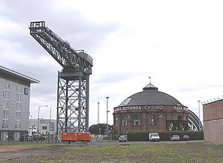
Finnieston is an area of Glasgow, Scotland, situated on the north bank of the River Clyde roughly between the city's West End and the city centre.

Linthouse is a neighbourhood in the city of Glasgow, Scotland. It is situated directly south of the River Clyde and lies immediately west of Govan, with other adjacent areas including Shieldhall and the Southern General Hospital to the west, and Drumoyne to the south. Although it is currently located within the Govan ward of Glasgow City Council, it was in fact a distinct area separate from Govan until 1901 when it willfully became part of the Burgh of Govan in turn both areas were annexed to Glasgow in 1912.

Whiteinch is an area in the city of Glasgow, Scotland. It is situated directly north of the River Clyde, between the Partick and Scotstoun areas of the city. Whiteinch was at one stage part of the burgh of Partick, until that burgh's absorption into the expanding city of Glasgow in 1912, and part of the Parish of Govan.

Shieldhall is a district in the Scottish city of Glasgow. It is situated directly south of the River Clyde and is part of the wider Govan area.
Glasgow Harbour in the following paragraphs is about a private sector urban regeneration scheme at Partick in the West End of the city of Glasgow, Scotland. It is not the history and development of the wider and internationally famous Glasgow Harbour from Glasgow Green to Clydebank which developed from the early 1800s and witnessed the birth and growth of modern shipbuilding and shipping.

The Renfrew Ferry is a passenger ferry service linking the north and south banks of the River Clyde in Scotland. The service, operated by Clydelink without subsidy, crosses between Renfrew and Yoker, close to Glasgow City Centre and is the last Clyde crossing this far upstream.

Pacific Quay is an area south of the River Clyde in Glasgow, Scotland. It is located at the former Plantation Quay and Princes' Dock Basin. The Princes' Dock Basin was the largest on the River Clyde when it was opened by the Clyde Navigation Trust in 1900. It ceased to be used as a commercial dock by the Clyde Port Authority in the 1970s as the volume of Shipping using the Upper Clyde declined with the onset of containerization. The site was later used for the Glasgow Garden Festival in 1988. The former electric generating station and pumping house, "Four Winds" which was used to pump water between the rotundas and generate power for the electric cranes still stands and is now home to a consultant engineers and radio station. The name 'Pacific Quay' has no historical significance, as it was created simply as a marketing enterprise following the land being reclaimed for commercial use after the Garden Festival closure. It did not reflect the site as a departure point for ships bound for the Pacific Rim.

The Clyde Arc is a road bridge spanning the River Clyde in Glasgow, Scotland, connecting Finnieston near the SEC Armadillo and SEC with Pacific Quay and Glasgow Science Centre in Govan. Prominent features of the bridge are its innovative curved design, and that it crosses the river at an angle. The Arc is the first city centre traffic crossing over the river built since the Kingston Bridge was opened to traffic in 1970.
Clyde Fastlink is a high frequency bus rapid transit system in Glasgow, Scotland. The system was designed to provide greater connectivity and faster journey times between Glasgow City Centre and the Queen Elizabeth University Hospital in Govan, as well as to several other key developments along the north and south banks of the Clyde Waterfront.

The 20 km long Clyde Waterfront Regeneration, launched in 2003, embraced a section of the River Clyde in Scotland that runs from Glasgow Green in the city's center to Dumbarton down river. This scene focussed on earlier initiatives underway from the 1980s, and as a separate marketing tool, with several local authorities involved, came to an end in 2014.

The Queen Elizabeth University Hospital (QEUH) is a 1,677-bed acute hospital located in Govan, in the south-west of Glasgow, Scotland. The hospital is built on the site of the former Southern General Hospital and opened at the end of April 2015. The hospital comprises a 1,109-bed adult hospital, a 256-bed children's hospital and two major Emergency Departments; one for adults and one for children. There is also an Immediate Assessment Unit for local GPs and out-of-hours services, to send patients directly, without having to be processed through the Emergency Department. The retained buildings from the former Southern General Hospital include the Maternity Unit, the Institute of Neurological Sciences, the Langlands Unit for medicine of the elderly and the laboratory. The whole facility is operated by NHS Greater Glasgow and Clyde, and is one of the largest acute hospital campuses in Europe.
Kelvinhaugh is a neighbourhood in the city of Glasgow, Scotland. It is situated directly north of the River Clyde in the West End of the city.
Kelvingrove is a neighbourhood in the city of Glasgow, Scotland. It is situated north of the River Clyde in the West End of the city, and directly borders Kelvingrove Park to the north and the grounds of the Kelvingrove Art Gallery and Museum to the west. Its other boundaries are not precisely defined, but roughly correspond to Sauchiehall Street to the south opposite the Sandyford neighbourhood, and the Charing Cross area to the east.

Sandyford is an area of Glasgow, Scotland. It is north of the River Clyde and forms part of the western periphery of the city centre. Formerly the name of a ward under Glasgow Town Council in the first part of the 20th century, it is within a continuous area of fairly dense urban development bordering several other neighbourhoods whose mutual boundaries have blurred over time, and is possibly less well known than all of the places which adjoin it, particularly Anderston and Finnieston.

Clydeside distillery is a Scotch whisky distillery in Glasgow, Scotland. When production began in 2017, Clydeside was the first active distillery in Glasgow city centre for over 100 years.

