Highway 3A is the designation of two segments of highway in the southern part of British Columbia.

The Kootenay River or Kootenai River is a major river of the Northwest Plateau in southeastern British Columbia, Canada, and northern Montana and Idaho in the United States. It is one of the uppermost major tributaries of the Columbia River, the largest North American river that empties into the Pacific Ocean. The Kootenay River runs 781 kilometres (485 mi) from its headwaters in the Kootenay Ranges of the Canadian Rockies, flowing from British Columbia's East Kootenay region into northwestern Montana, then west into the northernmost Idaho Panhandle and returning to British Columbia in the West Kootenay region, where it joins the Columbia at Castlegar.
Kootenay, Kootenai, and Kutenai may refer to:

Castlegar is a community in the West Kootenay region of British Columbia, Canada. In the Selkirk Mountains, at the confluence of the Kootenay and Columbia Rivers, it is a regional trade and transportation centre, with a local economy based on forestry, mining and tourism.

Kootenay Lake is a lake located in British Columbia, Canada. It is part of the Kootenay River. The lake has been raised by the Corra Linn Dam and has a dike system at the southern end, which, along with industry in the 1950s–70s, has changed the ecosystem in and around the water. The Kootenay Lake ferry is a year-round toll-free ferry that crosses between Kootenay Bay and Balfour. The lake is a popular summer tourist destination.

Glacier National Park is part of a system of 43 parks and park reserves across Canada, and one of seven national parks in British Columbia. Established in 1886, the park encompasses 1,349 km2 (521 sq mi), and includes a portion of the Selkirk Mountains which are part of the larger grouping of mountains, the Columbia Mountains. It also contains the Rogers Pass National Historic Site.
Kootanae House, also spelled Kootenae House, was a North West Company fur trading post built by Jaco Finlay under the direction of David Thompson near present-day Invermere, British Columbia in 1807. It was abandoned in 1812. In 1808 Thompson reckoned its location as 50°32′12″N115°56′15″W. The actual location is Kootenae House National Historic Site, located at 50.526624°N 116.045440°W.
The International Selkirk Loop is a 280-mile-long (450 km) scenic highway in the U.S. states of Idaho and Washington, as well as the Canadian province of British Columbia. The loop encircles the Selkirk Mountain Range, and offers several side trips aside from the main route. Included on the loop is the Kootenay Lake Ferry, the longest free ferry in the world. The portion of the loop in the United States has been designated an All-American Road by the United States Department of Transportation.

Montrose is in the West Kootenay region of southeastern British Columbia. The village lies 7 kilometres (4 mi) east of the city of Trail along Highway 3B.

City of Ainsworth was a paddle steamer sternwheeler that worked on Kootenay Lake in British Columbia, Canada from 1892 to 1898.

The Moyie is a paddle steamer sternwheeler that worked on Kootenay Lake in British Columbia, Canada from 1898 until 1957.

Ainsworth Hot Springs, previously named Ainsworth, is a historic village on Kootenay Lake in British Columbia, Canada and has a population of 20. Founded on May 31, 1883, it is the oldest surviving community on Kootenay Lake. Ainsworth Hot Springs is located on Highway 31, 11 miles (18 km) north of Balfour and 12 miles (19 km) south of Kaslo, British Columbia. Today, Ainsworth Hot Springs and the Cody Caves are a popular destination for tourists and spelunkers.

Bonnington was a sternwheel steamboat that ran on the Arrow Lakes in British Columbia from 1911 to 1931. Bonnington and two sisterships were the largest sternwheelers ever built in British Columbia. Bonnington was partially dismantled in the 1950s, and later sank, making the vessel the largest freshwater wreck site in British Columbia.

Lytton was a sternwheel steamboat that ran on the Arrow Lakes and the Columbia River in southeastern British Columbia and northeastern Washington from 1890 to 1904.
Boswell is an unincorporated community in the West Kootenay region of southeastern British Columbia. The former steamboat landing and temporary ferry terminal is adjacent to McGregor Creek on the east shore of the south arm of Kootenay Lake. Comprising a few kilometres stretched along BC Highway 3A, the location is by road about 48 kilometres (30 mi) north of Creston and by road and ferry about 76 kilometres (47 mi) southeast of Nelson.
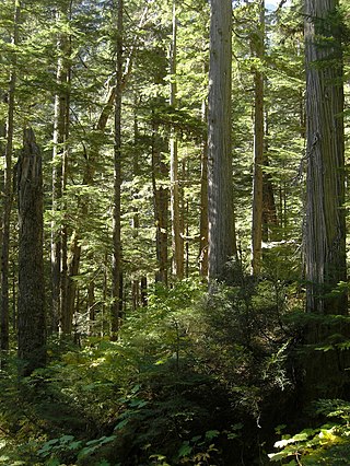
The Incomappleux River is in the West Kootenay region of southeastern British Columbia, Canada. Entering the Beaton Arm of Upper Arrow Lake, the river is a major tributary of the Columbia River. The upper reaches of the Incomappleux valley are home to some of the only inland temperate rainforest in the world.

The Kootenay Lake ferry is a ferry across Kootenay Lake in southeastern British Columbia, which operates between Balfour, on the west side of the lake, and Kootenay Bay, on the east side. The MV Osprey 2000 and the MV Balfour are the two vessels used.
The Nelson Range is a subrange of the Selkirk Mountains in the West Kootenay region of British Columbia, Canada. It is located south of the west arm of Kootenay Lake between the Salmo (W) and Kootenay Rivers (E) and also to the west of the south arm of Kootenay Lake. The range gets its name from the City of Nelson, which is on the south bank of the West Arm of Kootenay Lake and at the foot of the range's northwestern slopes.
Shutty Bench is a small rural community about 6 kilometres (4 mi) north of Kaslo in the West Kootenay region of southeastern British Columbia. The former steamboat landing is at the mouth of Shutty Creek on the western shore of Kootenay Lake. The locality, on BC Highway 31, is about 75 kilometres (47 mi) by road northeast of Nelson.
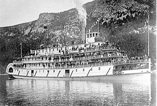
Nasookin was a sternwheel-driven steamboat that operated on Kootenay Lake in British Columbia from 1913 to 1947. Nasookin was one of the largest inland steam vessels ever to operate in British Columbia and the Columbia River and its tributaries. Nasookin became surplus to its original owner, the Canadian Pacific Railway, and was transferred to the British Columbia Provincial government which used it as an auto ferry until 1947. Negligent mooring of the steamer in 1948 led to irreparable damage to its hull, and it was later scrapped. Portions of the upper works were salvaged and used as a house.

