The nearest town is Kirriemuir.[2] The glen is in the south eastern Grampians, and the river which runs through it drains into Glen Clova, which extends towards the coast of Angus.[3]
An ancient track, Jock's Road, that starts in the glen, ends at Braemar. The origin of the name is that Duncan Macpherson, a rich Scot, returned from Australia in the late 19th century, bought the Glen Doll estate, and sought to ban people from crossing his land. John (or Jock) Winter fought him, and the Scottish Rights of Way and Access Society took a challenge through all the courts to the House of Lords, finally winning the day in 1888.[4]
Deer stalking takes place in the glen in late summer and autumn.
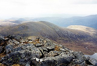
A popular walk heads south west through the Glendoll Forest before climbing steeply up the Kilbo Path that links Glen Doll with Glen Prosen. At the top this reaches a high pass giving easy access to two Munros, these are Driesh to the east and Mayar to the west.
In April 1998, Angus Council instituted a Ranger Service for the Angus Glens, with two full-time rangers, which has its base in Glen Doll.[1]
Kirriemuir, sometimes called Kirrie, is a burgh in Angus, Scotland. Its history reaches back to earliest recorded times, when it is thought to have been a major ecclesiastical centre. Later it was identified with witchcraft, and some older houses still feature a "witches stane" to ward off evil. In the 19th century, it was an important centre of the jute trade. The playwright J. M. Barrie was born and buried here, and a statue of Peter Pan stands in the town square.
Càrn Eige, sometimes spelt Càrn Eighe, is a mountain in the north of Scotland. At an elevation of 1,183 metres (3,881 ft) above sea level, it is the highest mountain in northern Scotland, the twelfth-highest summit above sea level in the British Isles, and, in terms of relative height, it is the second-tallest mountain in the British Isles after Ben Nevis. The highpoint of the historic county of Ross and Cromarty, it is the twin summit of the massif, being mirrored by the 1,181-metre (3,875 ft) Mam Sodhail, to the south on the same ridge.
Ben Lui is a mountain in the southern Highlands of Scotland, at the head of Glen Fyne. It has five well-defined ridges radiating out from the summit. Four corries lie between the ridges; including Coire Gaothaich which lies on the northeast side of the mountain.
Sgurr na Lapaich is a mountain in the Northwest Highlands of Scotland, situated north of Loch Mullardoch in the high ground that separates Glen Cannich and Glen Strathfarrar. The mountain reaches a height of 1,150 metres, and is the fourth highest mountain north of the Great Glen. There is no higher ground to the north of it in Great Britain.
Mullach nan Coirean is a Scottish mountain situated in the Mamores group of hills. It reaches a height of 939 metres (3081 feet) and is located eight kilometres north-west of Kinlochleven. It is the most westerly of the ten Munros in the Mamores and it is connected to the adjoining mountain of Stob Bàn by a bealach with a height of 846 metres; these two Munros are often climbed together from Glen Nevis. The mountain's name translates from the Gaelic as Summit of the Corries or Top of the Corries and this is quite fitting as Mullach nan Coirean has four corries on its slopes. Mullach can also mean a "roof". However it is unusual that the name does not include reference to the mountain's distinct red tinge cause by its red granite rock.
Mòruisg is a Scottish mountain situated in the Glencarron and Glenuig Forest, 10 kilometres south west of the village of Achnasheen in the Highland council area.
Beinn Dubhchraig is a Scottish mountain that is situated eight kilometres west of Crianlarich in the northern part of the Loch Lomond and the Trossachs National Park.
Sròn a’ Choire Ghairbh is a Scottish mountain situated on the northern side of Loch Lochy, 13 kilometres north of Spean Bridge in the Highland Council area.
Meall na Teanga is a Scottish mountain located in the Highland council area, 11 km (7 mi) north of Spean Bridge.
Beinn Challuim is a Scottish mountain located in the very northern part of the Loch Lomond and the Trossachs National Park six kilometres east northeast of the village of Tyndrum in the Stirling Council area. The mountain stands in the Forest of Mamlorn, an ancient deer forest in Breadalbane.
Creise is a Scottish mountain that stands at the eastern end of Glen Coe, just to the south of the A82 road, some 26 kilometres South-southeast of Fort William in the Highland Council area. The mountain was previously known as Clach Leathad in the Munro Tables prior to 1981, its name being changed to Creise when the highest point was found to be 1200 metres further north along the summit ridge when using new mapping techniques.
Càrn nan Gobhar is a Scottish mountain situated on the northern side of Loch Mullardoch in the upper part of Glen Cannich. It stands some 50 kilometres west-southwest of the city of Inverness in a remote group of four Munros informally known as “The Mullardochs” which form the high ground between Loch Mullardoch and Loch Monar.
Creag Mhòr is a Scottish mountain which stands in the ancient Forest of Mamlorn deer forest, it is located ten kilometres north east of Tyndrum on the border between the Perth and Kinross and Stirling council areas.
Beinn Sgritheall is the highest mountain in the Glenelg area of the Highlands of Scotland. The main approach is via Arnisdale on the shores of Loch Hourn or via Gleann Beag to the north, with its well-known brochs. The view from the summit was described by Sir Hugh Munro, a founder member of the Scottish Mountaineering Club, as "perhaps the most beautiful I have seen in Scotland".
Stob Choire Claurigh is a Scottish mountain situated 16 km (10 mi) east of Fort William in the Lochaber district of the Highland council area. It is part of one of the best ridge walks on the Scottish mainland.
Maoile Lunndaidh is a Scottish mountain situated 13 km south of Achnasheen in the Ross and Cromarty district of the Highland council area. It is part of the high ground between Loch Monar and Gleann Fhiodhaig.
Webster's High School is a secondary school in Kirriemuir, Angus, Scotland. The school has run for over 150 years, and there are over 650 pupils in the school.
Corrie Fee is a glacier-carved corrie situated at the head of Glen Clova in the Angus Glens of Scotland. It forms part of Corrie Fee National Nature Reserve (NNR), which is managed by Scottish Natural Heritage (SNH) and lies within the Cairngorms National Park. The adjoining Corrie Sharroch and the slopes of Craig Rennet are also included in the NNR.
Beinn a’ Chaorainn is a Scottish mountain situated on the northern side of Glen Spean in the Lochaber region of the Highland Council area. The mountain which is located 30 km east-northeast of Fort William is one of several of the same name in the Scottish Highlands and should not be confused with another well known Beinn a’ Chaorainn in the Cairngorms.
Sgùrr Thuilm is a mountain in the Glenfinnan area of the Highlands of Scotland. It stands at the head of Glen Finnan approximately 7 kilometres (4 mi) north of Loch Shiel.
This page is based on this Wikipedia article Text is available under the CC BY-SA 4.0 license; additional terms may apply. Images, videos and audio are available under their respective licenses.