The City of Glen Eira is a local government area in Victoria, Australia. It is located in the south-eastern suburbs of Melbourne. It has an area of 39 square kilometres (15.06 sq mi) and has an estimated population of 153,858.

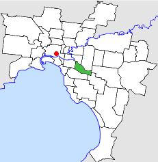
Caulfield is a suburb in Melbourne, Victoria, Australia, 10 kilometres (6.2 mi) south-east of Melbourne's Central Business District, located within the City of Glen Eira local government area. Caulfield recorded a population of 5,748 at the 2021 census.

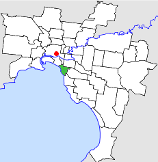
Elsternwick is an inner suburb in Melbourne, Victoria, Australia, 9 km south-east of Melbourne's Central Business District, located within the City of Glen Eira local government area. Elsternwick recorded a population of 10,887 at the 2021 census.
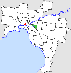
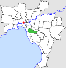
Caulfield South is a suburb in Melbourne, Victoria, Australia, 10 km south-east of Melbourne's Central Business District, located within the City of Glen Eira local government area. Caulfield South recorded a population of 12,328 at the 2021 census.

Caulfield North is an inner suburb in Melbourne, Victoria, Australia, 8 km south-east of Melbourne's Central Business District, located within the City of Glen Eira local government area. Caulfield North recorded a population of 16,903 at the 2021 census.
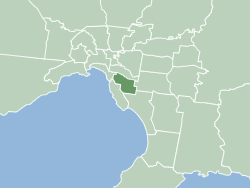
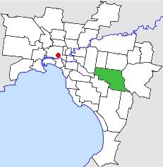
Caulfield East is an inner suburb in Melbourne, Victoria, Australia, 10 km south-east of Melbourne's Central Business District, located within the City of Glen Eira local government area. Caulfield East recorded a population of 1,293 at the 2021 census.

Bentleigh West Primary School is a government primary school located in the suburb of Bentleigh in the City of Glen Eira, about 13 kilometres (8.1 mi) out of Melbourne's city centre, in the state of Victoria, Australia.

Glen Eira College (GEC) is a co-educational, public secondary school located in Caulfield East, Victoria, Australia. It is situated on Booran Road and backs on to Caulfield Racecourse Reserve.
The City of St Kilda was a local government area on Port Phillip, about 5 kilometres (3.1 mi) south of Melbourne, the state capital of Victoria, Australia. The city covered an area of 8.70 square kilometres (3.36 sq mi), and existed from 1855 until 1994.
The City of Hawthorn was a local government area about 4 kilometres (2.5 mi) east of Melbourne, the state capital of Victoria, Australia, on the southeast bank of the Yarra River. The city covered an area of 9.71 square kilometres (3.75 sq mi), and existed from 1860 until 1994.
The City of Waverley was a local government area about 20 kilometres (12 mi) east-southeast of Melbourne, the state capital of Victoria, Australia. The city covered an area of 60.86 square kilometres (23.50 sq mi), and existed from 1857 until 1994.
The City of Malvern was a local government area about 9 kilometres (6 mi) southeast of Melbourne, the state capital of Victoria, Australia. The city covered an area of 15.88 square kilometres (6.13 sq mi), and existed from 1856 until 1994, when it was merged with the City of Prahran to create the City of Stonnington.
The City of Caulfield was a local government area about 10 kilometres (6 mi) southeast of Melbourne, the state capital of Victoria, Australia. The city covered an area of 21.97 square kilometres (8.48 sq mi), and existed from 1857 until 1994.

The City of Moorabbin was a local government area about 20 kilometres (12 mi) southeast of Melbourne, the state capital of Victoria, Australia. The city covered an area of 53.13 square kilometres (20.51 sq mi), and existed from 1862 until 1994.
The Dandenong railway line triplication project was an initiative of the Government of Victoria, Australia, to add sections of third track from Caulfield to Dandenong on the Gippsland railway line to increase capacity of and relieve congestion.

Kingsway is a shopping, dining and entertainment precinct at the town centre of Glen Waverley, a southeastern suburb of Melbourne, Victoria, Australia. It starts off at the northern end from High Street, and runs north-south parallel to Springvale Road before curving east at its southern end to join the latter as a T-intersection.
Glen Eira Sports and Aquatic Centre (GESAC) is an aquatic centre that was developed by Hansen Yuncken and is owned by City of Glen Eira. It is a rival to Melbourne Sports and Aquatic Centre as it contains a 50-metre outdoor pool, 25 metre indoor pool, water slides, leisure pools, gymnasium and a stadium. It was constructed at a total cost of $44m dollars, with significant contributions from Federal and Victorian State Governments.
Caulfield Hospital is a hospital based in Melbourne, Victoria, originally opened as the No. 11 Australian General Hospital in 1916. It focuses on rehabilitation, care, and mental health, particularly for the elderly. It is situated on Kooyong Road.

