Related Research Articles

The Marble Range is a small mountain range adjoining the Fraser River on the southwestern edge of the Interior Plateau of British Columbia. It has an area of 1,250 square kilometres and about 65 km NNW to SSE and about 20 km wide. Its southern flank is the north wall of Marble Canyon and the valley occupied by the ranching and First Nations community of Pavilion.
The Hurley River is a major tributary of the Bridge River of west-central British Columbia that was earlier known as the South Fork of that larger river. It was for a while known as "Hamilton's River" after Danny Hamilton, an American who was among the first to settle in the goldfields region of the upper Bridge River. By the 1920s that name was changed to the Hurley River, commemorating one of the main pioneers of the Lillooet Country, Dan Hurley.
Ruby Creek is a locality on the Fraser River in the District of Kent, British Columbia, Canada, in the Upper Fraser Valley region, located on BC Highway 7 and the mainline of the Canadian Pacific Railway, near the confluence of Ruby Creek with the Fraser, northeast of Sea Bird Island. Ruby Creek Indian Reserve No. 2 of the Skawahlook First Nation is nearby, as is also Skawahlook Indian Reserve No. 1, one mile northeast of the mouth of Ruby Creek. Also in the locality is Lukseetsissum Indian Reserve No. 9 of the Yale First Nation.

The Bonaparte Indian Band a.k.a. Bonaparte First Nation, is a member band of the Shuswap Nation Tribal Council of the Secwepemc (Shuswap) people.
The Whispering Pines/Clinton Indian Band, also called the Pellt'iq't First Nation is a member of the Secwepemc (Shuswap) Nation, located in the Central Interior region of the Canadian province of British Columbia. Its main Indian reserve is located at Clinton, British Columbia. It was created when the government of the then-Colony of British Columbia established an Indian Reserve system in the 1860s. It is a member government of the Shuswap Nation Tribal Council.

The Canoe Creek Band/Dog Creek Indian Band, also known as the Canoe Creek First Nation and/or Dog Creek First Nation is a First Nations government of the Secwepemc (Shuswap) Nation, located in the Fraser Canyon-Cariboo region of the Central Interior of the Canadian province of British Columbia. It was created when the government of the then-Colony of British Columbia established an Indian Reserve system in the 1860s. It is a member government of the Northern Shuswap Tribal Council.
The Alkali Lake Indian Band, also known as the Esketemc First Nation, is a First Nations government of the Secwepemc (Shuswap) people, located at Alkali Lake in the Cariboo region of the Central Interior of the Canadian province of British Columbia. It was created when the government of the then-Colony of British Columbia established an Indian Reserve system in the 1860s. It is one of three Secwepemc bands that is not a member of either the Shuswap Nation Tribal Council or the Northern Shuswap Tribal Council.
The Ashcroft First Nation is a First Nations government Thompson Canyon area of the Central Interior of the Canadian province of British Columbia. Its Indian Reserves are located near the town of Ashcroft, British Columbia, it is a member of the Nlaka'pamux Nation Tribal Council.
The Lytton First Nation, a First Nations band government, has its headquarters at Lytton in the Fraser Canyon region of the Canadian province of British Columbia. While it is the largest of all Nlaka'pamux bands, unlike all other governments of the Nlaka'pamux (Thompson) people, it is not a member of any of the three Nlaka'pamux tribal councils, which are the Nicola Tribal Association, the Fraser Canyon Indian Administration and the Nlaka'pamux Nation Tribal Council.
The Stone First Nation or Yunesit'in First Nation is a band government of the Yunesit'in subgroup of the Tsilhqot'in people, whose territory is the Chilcotin District in the western Central Interior region of the Canadian province of British Columbia. It is a member of the Tsilhqot'in Tribal Council. The people of the Stone First Nation are known as the Yunesit'in in the Chilcotin language.
Fountain is an unincorporated rural area and Indian Reserve community in the Fraser Canyon region of British Columbia, Canada, located at the ten-mile (16 km) mark from the town of Lillooet on BC Highway 99, which in that area is also on the route of the Old Cariboo Road and is located at the junction of that route with the old gold rush-era trail via Fountain Valley and the Fountain Lakes.

Siska, also known historically as Cisco, is a locality in the Fraser Canyon of British Columbia, Canada 9.4 kilometres south of the town of Lytton. It is at Siska that the Canadian Pacific and Canadian National Railways switch from one side of the river to the other, due to the impossibility of both railways occupying the same bank of the Fraser due to the narrow and steep terrain. The resulting pair of bridges, with the CNR bridge just upstream of the CPR's, and the CPR's bridge's west foot entering the Cantilever Bar Tunnel into the side of Cisco Bluff, remains one of the most famous images of the CPR's route through British Columbia today and is easily viewable from the adjacent Trans-Canada Highway.
The Little River is a 35 km river in the Cariboo region of British Columbia, Canada, rising in the Cariboo Mountains north of the North Arm of Quesnel Lake and running roughly westwards to enter Cariboo Lake conjointly with the upper Cariboo River.
Kimsquit is a former village of the Nuxalk at the mouth of the Dean River on the northeast side of Dean Channel in the Central Coast region of British Columbia, Canada. Kemsquit Indian Reserve No. 1 is nearby at 52°49′00″N126°58′00″W, which is on Kimsquit Bay; Kimsquit Mountain is nearby.
The Compton Névé is an icefield in the Pacific Ranges of the Coast Mountains in southwestern British Columbia, Canada, located southeast of the Homathko Icefield and Mount Gilbert and to the south of the Bishop River. It lies west of the Lillooet Icecap and is connected to it by the Ring Glacier, which sits astride Ring Pass, the divide between the Lillooet and Bishop Rivers, and has an area of 714 km2 (276 sq mi).
The Spearhead Glacier is the largest glacier on the Spearhead Range, located on the opposite, northeast side of that range from the resort town of Whistler, British Columbia, Canada, and is serviced in part by the lift system of the Whistler Blackcomb ski resort. The glacier's apex is at the peak known as The Spearhead, which also lies at the head of the Blackcomb Glacier.
Greenway Sound is a sound in the area of the Broughton Archipelago, which lies on the north side of Queen Charlotte Strait in the Central Coast region of British Columbia, Canada. It is adjacent to Sutlej Channel, which lies on the north side of Broughton Island, the largest of the group, between it and the mainland. Greenway Point is on the south side of the sound.
Yale First Nation is a First Nations government located at Yale, British Columbia. Yale has 16 distinct reserves stretching from near Sawmill Creek to American Creek, with the most southern reserve situated at Ruby Creek in the District of Kent.
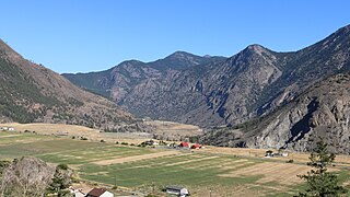
Marble Canyon 3, properly and most commonly referred to as Marble Canyon Indian Reserve No. 3, is an Indian Reserve of the Ts’kw’aylaxw First Nation, located at the southeast end of Marble Canyon, adjacent to BC Highway 99 just northwest of the Upper Hat Creek junction, which is about midway between the towns of Lillooet and Cache Creek. The main reserve of the Tx'kw'ylaxw/Pavilion Band is Pavilion Indian Reserve No. 1, located at the community of Pavilion, which lies at the northwest end of Marble Canyon, which is to say at the opening of the valley of Pavilion Creek into the Fraser Canyon.
Moran is a railway point on the BC Rail line north of Pavilion, British Columbia. The location, which is high on the side of the stretch of the Fraser Canyon known as Moran Canyon, is notable as the site of the proposed Moran Dam, and due to the steep, sandy embankment and railway grade saw a fatal train wreck in 2006.
References
Coordinates: 50°49′00″N121°51′00″W / 50.81667°N 121.85000°W
| This article about a location in the Cariboo Regional District, Canada is a stub. You can help Wikipedia by expanding it. |