Related Research Articles

The City of Glendale is a home rule municipality located in an exclave of Arapahoe County, Colorado, United States. The city population was 4,613 at the 2020 United States Census. Glendale is an enclave of the City and County of Denver and is the most densely populated municipality in Colorado. The city is a part of the Denver–Aurora–Lakewood, CO Metropolitan Statistical Area and the Front Range Urban Corridor.
West Newton, Indiana is a neighborhood located in southwestern Indianapolis. West Newton is situated ten miles (16.1 km) southwest of downtown Indianapolis in south central Decatur Township. It originated as a small Quaker-settled town. It has been incorporated into Indianapolis. The ZIP Code for West Newton is 46183.
The Mozel Sanders Homes is a housing development located on the near north-eastside of Indianapolis.
Fall Creek Place is one of many revitalized neighborhoods in inner Indianapolis, Indiana, United States. The neighborhood is bounded by Meridian Street on the west, Fall Creek Parkway on the north, just east of College Avenue on the east, and 22nd Street on the south. Before the project's Phase IV began in 2006, its eastern boundary was Park Avenue.
Bruce Grounds or Bruce Park was a baseball ground located in Broad Ripple, Indianapolis, Indiana. The ground was home to the Indianapolis Hoosiers of the American Association in 1884. It was also used for Sunday games by the Indianapolis Hoosiers of the National League in 1887.
Eagledale is a neighborhood on the west side of Indianapolis, Indiana. Eagledale is primarily suburban in nature, consisting of ranch homes built in the 1950s and 1960s by National Homes, which was based out of Lafayette, Indiana. This is one of the few suburban neighborhoods that the city of Indianapolis annexed prior to the 1970 consolidation of city and county governments known as Unigov.
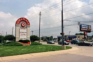
Nora is a community on the far north side of Indianapolis, Indiana, United States. Nora's neighborhoods typically feature diverse housing stock, large lots, and mature trees.

Indiana's 7th congressional district is a congressional district in the U.S. state of Indiana. It is entirely located within Marion County and includes most of Indianapolis, except for the southern side, which is located within the 6th district.

Oakmont is a village and special taxing district in Montgomery County, Maryland, United States. Chartered in 1918, the village includes both sides of Oak Place and the south side of Oakmont Avenue, across Old Georgetown Road from the National Institutes of Health, in the Bethesda postal area. The village has approximately 145 inhabitants in 52 homes.
Little Flower is a neighborhood on the near eastside of Indianapolis, Indiana. Its boundaries are 16th Street, 10th Street, Emerson Avenue, and Sherman Drive.
Glendale Town Center, formerly Glendale Shopping Center and known also as Glendale Mall, is a retail shopping center located at 6101 North Keystone Avenue in Indianapolis, Indiana. Its major stores are Target, Lowe's, Landmark Theatres, and a branch of the Indianapolis Public Library.
Arden is an affluent residential neighborhood on the north side of Indianapolis, Indiana. The neighborhood is about a 15-minute drive from downtown Indianapolis. It is bounded by 71st Street on the north, Meridian Street on the west, College Avenue on the east, and the White River on the south. Arden is north of the Broad Ripple Village neighborhood and south of the community of Meridian Hills.
Center Township is one of nine townships in Marion County, Indiana, in the United States. As of the 2020 census, its population was 153,549, up from 142,787 in 2010, and it contained 80,885 housing units. It is the most populated township in Marion County.

Hendricks County Airport, also known as Gordon Graham Field, is a public airport at 2749 Gordon Graham Blvd. in Danville, a town in Hendricks County, Indiana, United States. Owned by the Indianapolis Airport Authority, it is located 13 miles (21 km) west of the central business district of Indianapolis and serves as a reliever airport for Indianapolis International Airport. The airport is also two miles (3 km) southeast from the center of Danville.
Mapleton-Fall Creek (MFC) is a historic neighborhood in Indianapolis, bounded by Fall Creek Parkway South Drive on the east and south, by Meridian Street on the west, and by 38th Street on the north. The population was 3,460 as of the 2000 Census.
Indianapolis Park or Athletic Park (II) was a baseball ground in Indianapolis, Indiana. It was the Sunday home field of the Indianapolis Hoosiers baseball club of the National League from 1888 to 1889.
Sterling Landing is an extinct town in Lincoln County, in the U.S. state of Missouri. The GNIS classifies it as a populated place.
Wallace Junction is a ghost town in Taylor Township, Owen County, in the U.S. state of Indiana.

Market East is the newest of seven designated cultural districts in Indianapolis, Indiana. The district is on the east side of downtown and is bounded to the north by New York Street, to the south by the railroad tracks, to the west by Delaware Street and to the east by East Street.
Fall Creek Greenway, often referred to as Fall Creek Trail, is a shared-use path in Indianapolis, Indiana, United States. The greenway begins at the border of Fort Harrison State Park on Boy Scout Road in the northeast corner of the city, meandering southwest along Fall Creek. The greenway terminates at Burdsal Parkway and the Indiana Central Canal in Indianapolis's Riverside neighborhood. It is nearly 7 miles (11 km) long and connects with the Monon Trail just south of Fall Creek Parkway near the Mapleton-Fall Creek neighborhood. A second and final phase will complete a gap in the greenway between its current terminus to the intersection of Indiana Avenue and 10th Street.
References
39°51′57″N86°06′47″W / 39.86583°N 86.11306°W
| | This Indianapolis, Indiana-related article is a stub. You can help Wikipedia by expanding it. |
| | This Marion County, Indiana location article is a stub. You can help Wikipedia by expanding it. |