Glenelg Hopkins region
The region spans some 2.6 million hectares and extends from Ballarat in the Central Highlands of Victoria, Australia, west to the South Australian border and south to the coast. The southern two thirds are characterised by flat volcanic plains while the Grampians, Dundas Tablelands and Black Ranges dominate the northern third.

Victoria is a state in south-eastern Australia. Victoria is Australia's smallest mainland state and its second-most populous state overall, thus making it the most densely populated state overall. Most of its population lives concentrated in the area surrounding Port Phillip Bay, which includes the metropolitan area of its state capital and largest city, Melbourne, Australia's second-largest city. Victoria is bordered by Bass Strait and Tasmania to the south, New South Wales to the north, the Tasman Sea to the east, and South Australia to the west.

Australia, officially the Commonwealth of Australia, is a sovereign country comprising the mainland of the Australian continent, the island of Tasmania and numerous smaller islands. It is the largest country in Oceania and the world's sixth-largest country by total area. The neighbouring countries are Papua New Guinea, Indonesia and East Timor to the north; the Solomon Islands and Vanuatu to the north-east; and New Zealand to the south-east. The population of 25 million is highly urbanised and heavily concentrated on the eastern seaboard. Australia's capital is Canberra, and its largest city is Sydney. The country's other major metropolitan areas are Melbourne, Brisbane, Perth and Adelaide.

South Australia is a state in the southern central part of Australia. It covers some of the most arid parts of the country. With a total land area of 983,482 square kilometres (379,725 sq mi), it is the fourth-largest of Australia's states and territories by area, and fifth largest by population. It has a total of 1.7 million people, and its population is the second most highly centralised in Australia, after Western Australia, with more than 77 percent of South Australians living in the capital, Adelaide, or its environs. Other population centres in the state are relatively small; Mount Gambier, the second largest centre, has a population of 28,684.
The region has three major river drainage basins - the Hopkins, Glenelg and Portland Coast. The lower section of the Glenelg River is heritage listed for its environmental significance. Salt-wedge estuaries at the mouth of rivers entering the sea are environmentally significant. Extensive wetlands are a feature of the region and provide significant habitat for native biodiversity.

The Hopkins River, a perennial river of the Glenelg Hopkins catchment, is located in the Western District of Victoria, Australia.

The Glenelg River, a perennial river of the Glenelg Hopkins catchment, is located in the Australian states of Victoria and South Australia.
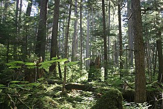
The Glenelg Hopkins region has a range of natural assets in the form of biodiversity, waterways and wetlands, soils, forests and coastal areas. These natural resources support a unique quality of life.
The south west region is an important part of provincial Victoria and boasts a diverse range of lifestyle, investment and working opportunities. The main economic drivers are agriculture, fisheries, retail, manufacturing, health and community services, education and construction. Blue gum plantations and mineral sands mining are recent additions to the region’s industries.

Kaipara Harbour is a large enclosed harbour estuary complex on the north western side of the North Island of New Zealand. The northern part of the harbour is administered by the Kaipara District and the southern part is administered by the Auckland Council. The local Māori tribe is Ngāti Whātua.

The Mitchell River is a river located in Far North Queensland, Australia. The river rises on the Atherton Tableland about 50 kilometres (31 mi) northwest of Cairns, and flows about 750 kilometres (470 mi) northwest across Cape York Peninsula from Mareeba to the Gulf of Carpentaria.

Soil salinity and dryland salinity are two problems degrading the environment of Australia. Salinity is a concern in most states, but especially in the south-west of Western Australia.
Landcare began in Victoria, Australia in 1986 with a group of farmers near St Arnaud in central Victoria forming the first Landcare group. Since then, the Landcare concept has developed into a movement, across Australia and now around the world. There are approximately 4000 Landcare groups in Australia, and the model is being used in about fifteen other countries.

Pittwater is a semi–mature tide dominated drowned valley estuary, located about 40 kilometres (25 mi) north of the Sydney central business district, New South Wales, Australia; being one of the bodies of water that separate greater Metropolitan Sydney from the Central Coast.

The Coomera River is a perennial river located in the South East region of Queensland, Australia. Its catchment lies within the Gold Coast and Scenic Rim Region local government areas and covers an area of 489 square kilometres (189 sq mi).

The Moyne River, a perennial river of the Glenelg Hopkins catchment, is located in the Western District of Victoria, Australia.
Natural resource management refers to the management of natural resources such as land, water, soil, plants and animals, with a particular focus on how management affects the quality of life for both present and future generations (stewardship).

The Bungala River is a river located on the Fleurieu Peninsula in the Australian state of South Australia.

The Sturt River, also known as the Sturt Creek and Warri Parri in the Kaurna language, is a river located in the Adelaide region of the Australian state of South Australia.

The Westcountry Rivers Trust is a waterway society and a registered charity No. 1135007 in the West Country of England, United Kingdom. The Trust was founded in 1995 and aims to protect and enhance the West Country's rivers and streams, and to work with the region's landowners, farmers and the wider community, mainly through education projects.
The Corangamite Catchment Management Authority (CMA) region spans 13,000 square kilometres of south-west Victoria, Australia. About 350,000 people live within the catchment area, which stretches from Ballarat to Geelong and along the coast to Peterborough.
The Mallee Catchment Management Authority (CMA) region is the largest catchment area in Victoria, Australia, covering approximately 3.9 million hectares – almost one-fifth of the State.

The Paroo-Darling National Park is a protected national park that is located in the Far West region of New South Wales, in eastern Australia. The 178,053-hectare (439,980-acre) national park spans two distinct regions in the outback area. This region covers the arid catchments of the Paroo River and the Paroo-Darling confluence to the south.
Wallis Lake, an open and trained wave dominated barrier estuary, is located within the Mid-Coast Council local government area in the Mid North Coast region of New South Wales, Australia. Wallis Lake is located adjacent to the towns of Forster and Tuncurry, and adjacent to the east coast, about 308 kilometres (191 mi) north of Sydney.
The San Francisco Estuary Partnership (Partnership) is one of the 28 National Estuary Programs created in the 1987 Amendments to the Clean Water Act. The Partnership is a non-regulatory federal-state-local collaboration working to restore water quality and manage the natural resources of the San Francisco Bay-Sacramento–San Joaquin River Delta estuary. The Partnership works with over 100 municipalities, non-profits, governmental agencies, and businesses and helps develop, find funding for, and implement over 40 projects and programs aimed at improving the health of the estuary. The partnership either directly implements these projects, or administers and manages grants, holds educational workshops and highlights project results. The Partnership is also the official representative for the San Francisco Bay region to the Most Beautiful Bays in the World.

Stingray Swamp Flora Reserve (SWFR) is located immediately north of Penrose township in the south-western region of Wingecarribee Shire. The reserve is primarily surrounded by the Penrose State Forest, which is a commercially active plantation forest administered by the Forest Corporation NSW. Pine species dominate the state forest with a mix of native vegetation types in isolated pockets and adjacent areas. Stingray Swamp Flora Reserve belongs to a larger wetland complex known as the Paddy’s River Wetland Complex (PRWC). These wetlands also form part of the Paddy’s River sub-catchment, which belong to the larger Hawkesbury-Nepean catchment. Historic use of this area has mainly been that of pine plantation, agriculture and mining activities. The forest is publicly accessible and therefore is a site of mixed recreational activities.

Healthy Land and Water Limited is an Australian not-for-profit organisation using evidence-based research and monitoring of South East Queensland waterways to determine catchment health. Queensland Government’s Department of Environment and Science, local councils, water utilities and industry co-fund the organisation to deliver scientific information about the region’s rivers and catchments with the stated aim of guiding on-ground rehabilitation efforts.

