A dam is a barrier that stops or restricts the flow of surface water or underground streams. Reservoirs created by dams not only suppress floods but also provide water for activities such as irrigation, human consumption, industrial use, aquaculture, and navigability. Hydropower is often used in conjunction with dams to generate electricity. A dam can also be used to collect or store water which can be evenly distributed between locations. Dams generally serve the primary purpose of retaining water, while other structures such as floodgates or levees are used to manage or prevent water flow into specific land regions.

A diversion dam is a dam that diverts all or a portion of the flow of a river from its natural course. Diversion dams do not generally impound water in a reservoir; instead, the water is diverted into an artificial water course or canal, which may be used for irrigation or return to the river after passing through hydroelectric generators, flow into a different river or be itself dammed forming an onground or groundwater reservoir or a storm drain.

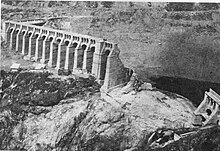
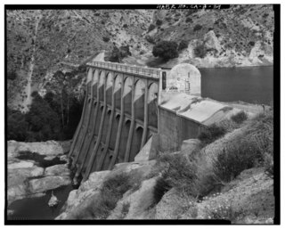
The St. Francis Dam, or the San Francisquito Dam, was a concrete gravity dam located in San Francisquito Canyon in northern Los Angeles County, California, United States, that was built between 1924 and 1926. The dam failed catastrophically in 1928, killing at least 431 people in the subsequent flood, in what is considered to have been one of the worst American civil engineering disasters of the 20th century and the third-greatest loss of life in California history.
An arch dam is a concrete dam that is curved upstream in plan. The arch dam is designed so that the force of the water against it, known as hydrostatic pressure, presses against the arch, causing the arch to straighten slightly and strengthening the structure as it pushes into its foundation or abutments. An arch dam is most suitable for narrow canyons or gorges with steep walls of stable rock to support the structure and stresses. Since they are thinner than any other dam type, they require much less construction material, making them economical and practical in remote areas.

The Mountain Dell Dam provides a water equalizing and storage reservoir for Salt Lake City, Utah located 10 miles (16 km) east of the city in northeastern Salt Lake County, near Interstate 80 in Parley's Canyon.

The Contra Dam, commonly known as the Verzasca Dam and the Locarno Dam, is an arch dam on the Verzasca River in the Val Verzasca of Ticino, Switzerland. The dam creates Lago di Vogorno 2 km (1.2 mi) upstream of Lake Maggiore and supports the 105 MW Verzasca hydroelectric power station. It was constructed between 1961 and 1965 and starting shortly after its reservoir was filled, a series of earthquakes related to its water load occurred until 1971. The dam is owned and operated by Verzasca SA and is the fourth tallest in Switzerland.

The New Waddell Dam is an embankment dam on the Agua Fria River in Maricopa County, Arizona, 35 miles (56 km) northwest of Phoenix. It serves as part of the Central Arizona Project (CAP) while also providing water for the Maricopa Water District. The dam creates Lake Pleasant with water from the Agua Fria and also the CAP aqueduct. In addition, it affords flood protection, hydroelectric power production and recreational opportunities. Construction on the dam began in 1985 and ended in 1994. Its reservoir submerged the Old Waddell Dam which was completed in 1927 after decades of planning.

Lake Eleanor is a reservoir located in the northwestern backcountry of Yosemite National Park at an altitude of 4,657 feet (1,419 m). The reservoir has a capacity of 26,100 acre-feet (32,200,000 m3) and a surface area of 953 acres (3.9 km2).

Lamaload Reservoir is a reservoir near Rainow, Cheshire, England. It lies in the South West Peak within the Peak District National Park, to the west of the Goyt Valley, and is fed by the River Dean. The reservoir is 0.93 km × 0.53 km, with a capacity of 1,909,000 m³, impounded by a multiple-arch, round-headed buttress dam in concrete, whose design was innovative at the time. It was built by Richard Costain Ltd in 1959–63 to serve Macclesfield, which lies to its west, and officially opened in 1965. The reservoir and associated water treatment works are owned by United Utilities. The area is a popular tourist spot, forming an access point for walkers to the surrounding moorland.

The Bartlett Dam is a concrete multiple-arch buttress dam on the Verde River, located 50 km northeast of Phoenix, Arizona. The dam creates Bartlett Lake and its primary purpose is irrigation water supply. It was the first dam constructed on the Verde River and the first of its type constructed by the U.S. Bureau of Reclamation. It was built between 1936 and 1939. It was named after Bill Bartlett, a government surveyor. It was listed on the National Register of Historic Places in 2017.

The Daniel-Johnson dam, formerly known as Manic-5, is a multiple-arch buttress dam on the Manicouagan River that creates the annular Manicouagan Reservoir. The dam is composed of 14 buttresses and 13 arches and is 214 km (133 mi) north of Baie-Comeau in Quebec, Canada. The dam was constructed between 1959 and 1970 for the purpose of hydroelectric power production and supplies water to the Manic-5 and Manic-5-PA power houses with a combined capacity of 2,660 MW. The dam is 214 m (702 ft) tall, 1,314 m (4,311 ft) long and contains 2,200,000 m3 (2,900,000 cu yd) of concrete, making it the largest dam of its type in the world.

The Çubuk-1 Dam is a concrete gravity dam on the Çubuk Stream near Çubuk in Ankara Province, Turkey. It is located 12 km north of the center of Ankara and was built to control floods and provide drinking water to the city. Its construction lasted from 1930 to 1936; Mustafa Kemal Atatürk attended its inauguration on November 3, 1936. It was the first concrete dam constructed in Turkey and the first constructed in Ankara, and is recognized by Turkey's Chamber of Civil Engineers as one of the country's top 50 engineering feats. It is owned and maintained by the Turkish State Hydraulic Works and was constructed at a cost of 2.32 million TRY.

Zengwen Dam, also spelled Tsengwen Dam, is a major earthen dam in Dapu Township, Chiayi County, Taiwan on the Zengwen River. It is the third tallest dam in Taiwan, and forms Zengwen Reservoir (曾文水庫), the biggest reservoir in Taiwan by volume. The dam stores water for irrigation of the Chianan Plain, Taiwan's most productive agricultural region, and provides flood control along the Zengwen River which flows through Tainan City. The dam supports a 50 megawatt hydroelectric power station.

The Pensacola Dam, also known as the Grand River Dam, is a multiple-arch buttress dam located between the towns of Disney and Langley on the Grand River in Mayes County, Oklahoma. The dam is operated by the Grand River Dam Authority and creates Grand Lake o' the Cherokees. After decades of vision and planning, it was constructed between 1938 and 1940 for the purposes of hydroelectric power generation, flood control and recreation. It is Oklahoma's first hydroelectric power plant and is referred to as the longest multiple-arch dam in the world.

The Sanmenxia Dam is a concrete gravity dam on the middle-reaches of the Yellow River near Sanmenxia Gorge on the border between Shanxi province and Henan Province, China. The dam is multi-purpose and was constructed for flood and ice control along with irrigation, hydroelectric power generation and navigation. Construction began in 1957 and was completed in 1960. It is the first major water control project on the Yellow River and was viewed as a major achievement of the new People's Republic of China. Subsequently, its image was printed on the country's bank notes. However, due to sediment accumulation in the reservoir, the dam later had to be re-engineered and renovated. The effects from sediment, which include flooding upstream, have placed the dam at the center of controversy and criticism-related arrests by the Chinese government.

The Miel I Dam, officially known as the Patángoras Dam, is a gravity dam on La Miel River just south of Norcasia in Caldas Department, Colombia. The dam was constructed between 1997 and 2002 for the primary purpose of hydroelectric power generation. At the time of its completion, the dam was the tallest roller-compacted concrete (RCC) dam in the world but was surpassed by the Longtan Dam in 2009.
The Okukubi Dam (億首ダム) is a trapezoidal cemented, sand and gravel (CSG) dam on the Okukubi River in Kin, Okinawa Prefecture, Japan. Construction began in 2009 and its reservoir was filled by 31 March 2013. It is the first trapezoidal CSG-type to be constructed as a main dam in the world. Its purpose is to provide flood control and water for municipal use along with the irrigation of 70 ha of land.
The Hunanzhen Dam is a trapezoidal buttress dam on the Qiantang River, located 27 km (17 mi) south of Quzhou in Zhejiang Province, China. The primary purpose of the dam is hydroelectric power generation but it also serves to provide for flood control and irrigation water supply. Construction on the dam began in 1958 but was halted in 1961. It recommenced in 1970, the first generator was operational in 1979 and the project complete in 1980. The original installed capacity of the dam's power plant was 170 MW but the plant was expanded with an additional 100 MW generator, commissioned in 2006.
The Jiangya Dam is a concrete gravity dam on the Loushui River, located 50 km (31 mi) northeast of Zhangjiajie in Hunan Province, China. The primary purpose of the multi-purpose dam is flood control but it also generates hydroelectricity, supplies water for irrigation and municipal use and improves navigation.
Little Rock Dam, also known as Littlerock Dam, or officially as Little Rock-Palmdale Dam, is a concrete gravity dam on Little Rock Creek in Los Angeles County, California, about 5 mi (8.0 km) south of Palmdale. The dam and Little Rock Reservoir are owned by the Palmdale Water District and Littlerock Creek Irrigation District and are used for agricultural and municipal water supply and flood control.