Glenrock State Conservation Area

Last updated

Glenrock State Conservation Area
Star Trails at Glenrock State Conservation Area , NSW.jpg
Star trails in Glenrock State Conservation Area
Australia New South Wales location map blank.svg
Red pog.svg
LocationAustralia
Nearest cityNewcastle
Coordinates 32°57′54″S151°43′44″E / 32.965°S 151.729°E / -32.965; 151.729
DesignationProtected conservation area
Governing bodyNSW National Parks and Wildlife Service
Website www.nationalparks.nsw.gov.au/visit-a-park/parks/glenrock-state-conservation-area
Walking track through open forest, Glenrock State Conservation Area Glenrock bush trail.JPG
Walking track through open forest, Glenrock State Conservation Area

Glenrock State Conservation Area is a protected conservation area located eight kilometres south of the central business district of Newcastle in the state of New South Wales, on the east coast of Australia. The park borders the coast and encompasses 534 hectares stretching from the residential suburbs of Merewether to Dudley within the Newcastle and Lake Macquarie Local Government Areas. [1]

Contents

Glenrock State Conservation Area is significant as it contains a large number of important remnant vegetation communities, contains a number of heritage sites, and is used by a wide variety of user groups. The park contains many cultural records, both Aboriginal and European, and is located within the Awabakal Local Aboriginal Land Council area. [1]

Overview

The park has many features including significant natural and landscape values, cultural heritage values (Aboriginal and European), recreational and tourism uses, and is important for research and education. [1]

Glenrock Lagoon, which is fed by Flaggy Creek, is located within the park and connects to Burwood Beach and the ocean through a small tidal channel.

The park is legislated as a state conservation area under the NSW National Parks and Wildlife Act 1974 which provides protection to conserve biodiversity, maintain ecosystem functions, and conserve places and features of cultural value. This protection also allows certain uses to occur whilst having regard to the natural and cultural values of the park, and provide compatible visitor and tourist use.

The park is used by a wide number of people and variety of interest groups. It contains a number of walking tracks of various grades, including tracks which are accessible by wheel chair. The Great North Walk traverses through the park. The park is well known for its mountain bike tracks which is allowed on designated tracks in the northern section of the park with horse riding also allowed in the northern section of the park or by permit. [2] Other uses include hang gliding, fishing, surfing, orienteering and beach related activities. The park has an active Scouts Australia NSW campsite, Glenrock Scout Camp, adjacent to Glenrock Lagoon.

Flora

The park contains remnant vegetation including many nationally significant vegetation communities, two endangered ecological communities, and five threatened flora species, and is recognised for its flora diversity. [1]

The park conserves native vegetation which has largely been removed or significantly degraded throughout the lower Hunter, and also includes a number of regionally significant vegetation communities. A total of twelve vegetation communities have been recorded in the park with eight considered poorly conserved at a national level, and two which are listed under the New South Wales Threatened Species Conservation Act as endangered ecological communities. Importantly the park includes some of the last areas containing Permian geology and sediments which are protected within conservation reserves, which explains why the park contains such a high flora diversity. [1]

Significant vegetation communities include littoral rainforest (national and state significance), Permian coastal clay grassland (national and state significance), Permian coastal gully rainforest (regional significance), Permian sheltered dry forest (national significance), Permian exposed coastal scrub (national significance), and Permian coastal clay Melaleuca scrub (national significance). [1]

The park contains five of the last seven known pockets of Littoral Rainforest in the lower Hunter, which is nationally listed as a critically endangered ecological community and as an endangered ecological community under the New South Wales Threatened Species Conservation Act 1995. Glenrock State Conservation Area provides important protection for the Littoral rainforest community which has been significantly reduced in area [3] and is a highly fragmented endangered ecological community. [4]

Endangered plants protected inside the park include the rough double tail (Dirius praecox), magneta lilly pilly (Syzygium paniculatum), white-flowered wax plant (Cynanchum elegans), black-eyed susan (Tetratheca juncea) and heath wrinklewort (Rutidosis heterogama). These plants are all listed as threatened species under the NSW Threatened Species Conservation Act 1995 and listed as nationally threatened under the Commonwealth Environment Protection and Biodiversity Conservation Act 1999.

The status of the park as a conservation area means these important species have some level of protection. This is especially important for some species such as Tetratheca juncea which is found in woodland and heath communities but now has a contracted north south range of 110 km, largely due to clearing for urban development, with historic southern populations around Sydney now extinct. [5]

The rainforest tree Syzygium paniculatum which is found in the park, is found only within the critically endangered littoral rainforests of NSW in disjunct populations often of less than 20 individuals. [6] Despite pressures from clearing for urban development, low population numbers and low genetic diversity, Syzygium paniculatum has been found to be persisting and producing viable and dispersible seed [6] thereby making protected areas where this species exist important for the preservation of this species.

Fauna

Glenrock State Conservation area contains habitat for a wide variety of animal species with 140 species of bird having been recorded in or nearby to the park including many notable threatened species such as the powerful owl (Ninox strenua), masked owl (Tyto novaehollandiae), turquoise parrot (Neophema pulchella), regent honeyeater (Xanthomyza phrygia) and swift parrot (Lathamus discolour). [1] These species are listed as vulnerable under the NSW Threatened Species Conservation Act 1995 except for the regent honeyeater (Xanthomyza phrygia) and swift parrot (Lathamus discolour) which are listed as endangered and also listed under the Commonwealth Environment Protection and Biodiversity Conservation Act 1999.

The swift parrot (Lathamus discolour) is a nationally significant migratory bird which is also listed as endangered on the IUCN Red List of Threatened Species. [7] The swift parrot only breeds in Tasmania between September and January and migrates to mainland Australia for wintering before returning to Tasmania in early spring. [8] The swift parrot disperses during winter through the landscape in a highly irregular and unpredictable manner based on availability of suitable food and habitat areas. [9] Protected areas such as Glenrock State Conservation Area are important for the swift parrot as the species breeding and wintering habitats have been substantially lost or altered, and while winter foraging is widespread across Tasmania, Victoria, NSW and into Queensland, the coastal areas of NSW are known to be used especially during periods of drought [10]

The regent honeyeater (Xanthomyza phrygia) is another species recorded in the park which is also listed as endangered on the IUCN Red List of Threatened Species. [11] This iconic species has experienced a significant decline in distribution and abundance [12] due to habitat loss and degradation. [11] The species is thought to be attracted to areas within the Lower Hunter by prolific flowering of the spotted gum (Corymbia maculata), [13] a species which is prevalent throughout the Glenrock State Conservation Area.

Reptiles recorded in the park include the diamond python (Morelia spilotes var. spilotes), the death adder (Acanthophis antarticus), tiger snake (Notechis scutatus), brown snake (Pseudonaja textilis), and the land mullet (Ergenia major).

Mammals which have been found in the park include the short beaked echidna (Tachyglossus aculeatus), long nosed bandicoot (Parameles nasuta), sugar glider (Petaurus breviceps), brown antechinus (Antechinus stuartii), and the common dunnart (Sminthopsis murina). Threatened mammal species recorded in the park include the common bent wing bat (Miniopterus schreibersii), little bent wing bat (Miniopterus australis), the nationally threatened grey-headed flying fox (Pteropus poliocephalus), and squirrel glider (Petaurus norfolcensis). [1]

The park is important for locally present species with large home ranges such as the threatened powerful owl (Ninox strenua) and grey-headed flying fox (Pteropus poliocephalus). The powerful owl has a large home range in excess of 1500 hectares and requires mature trees (Eucalypts) for roosting and with habitat which supports sufficient prey [14] The nationally vulnerable grey-headed flying fox (Pteropus poliocephalus), which is endemic to coastal eastern Australia, also requires a large home range and forages predominantly within 20 kilometres from camps however is known to forage up to 50 kilometres. [15] The urban area around the park has been significantly altered and disturbed with few surrounding large sized bush blocks [1] making Glenrock State Conservation Area an important habitat and refuge for a wide variety of species, such as the Powerful Owl and Grey Headed Flying Fox, which require large home range areas containing Eucalyptus forest.

Cultural heritage

Glenrock State Conservation Area is part of Awabakal Country and the park is believed to have been inhabited since the Pleistocene. [1] The land and landscape within the park is significant to the Awabakal and other Aboriginal peoples, with many sites recorded, including middens, axe grinding groove sites, camp sites and a quarry. [16]

European sites include Australia’s first road/tram tunnel (c1846), Australia’s first railway tunnels (c1861 and 1862), remains of Australia’s first commissioned copper smelter (c1851), remains of Burwood Colliery and a coastal railway. [16] The early coal mining sites within the park are listed on the NSW State Heritage Register.

There are over 145 known cultural sites recorded throughout the park.

Environmental threats

Glenrock State Conservation Area has been affected by a range of land use practices which have caused damage and include habitat disturbance and fragmentation, past mining and other resource use, development by utilities, past and present recreational activities. These have manifested in a number of threats that exist for the park including soil erosion from poorly designed easements and trails, impacts to water quality from urban stormwater and effluent surcharges from a sewerage pipeline, introduced plants and animals, fire management and climate change. [1]

An indicator of the pressures these threats can have is evident in the presence of bell miner associated dieback which is known to occur in several locations throughout the park. [1] While the specific factors that cause bell miner associated dieback are unclear, it is considered to be related to stress on the forest community and to such things as forest disturbance, changes in tree stand structure, an absence of regular burning, development of a dense understory, increase in foliar nutrients, infestation of tree crowns by psyllids, and colonisation by the bell miner. [17] A bush regeneration plan is being implemented in the park to address many of the impacts that contribute to bell miner associated dieback.

Fire management is an important aspect of park management. The unnatural exclusion of fire changes soils and nutrient processes which creates an unfavourable environment for eucalypts, creating a more favourable environment for arbivores and competitors. [18] A fire management plan exists for the park which shows that large areas of the park are classified as being either underburnt or almost underburnt and below thresholds required for some of the different vegetation types, predominantly the dry sclerophyll forest. [19] An appropriate fire strategy can maintain forest health [18] and is also likely to assist in limiting the effects of bell miner associated dieback. [1] [17]

A number of weed species exist in the park including bitou bush (Chrysanthemoides monilifera ssp. rotundata), lantana (Lantana camara) and blackberry (Rubis fruticosus), all of which are listed on the Noxious Weeds Act 1993. Bitou bush (Chrysanthemoides monilifera ssp. rotundata) is a major environmental weed along the south eastern coast of Australia within littoral habitats and is of particular concern in Glenrock State Conservation Area as it is widespread and is affecting a number of the endangered ecological communities and threatened species. [1] This weed is listed as a key threatening process under the Threatened Species Conservation Act 1995 and accordingly the parks bush regeneration plan and pest management strategy aims to target the management of this species.

Management

Glenrock State Conservation Area is managed by the NSW National Parks and Wildlife Service. A sewage treatment plant is located on designated land within the park boundaries which is owned and operated by Hunter Water Corporation. Electricity easements also exist throughout the park containing transmission lines which are managed by Energy Australia.

A Conservation Management Plan and Cultural Tourism Plan for the northern section of the park was completed in 2003 [16] which formed an important input into the development of a Plan of Management which was adopted in September 2010. [1] The Glenrock State Conservation Area Plan of Management (2010), which was prepared by the NSW Department of Environment and Climate Change outlines the attributes of the park, management priorities, visitor opportunities and education, research and monitoring, and relevant operational management issues.

Management priorities focus on managing impacts from the various threats to the park, impacts from the wide variety of activities that occur in the park, and protection of the conservation and cultural values. [1]

Newcastle Council has prepared a Coastline Management Plan which includes the Burwood Beach section of the park and identifies the collaborative approach required to manage the park given the diverse number of stakeholders who have an interest. [20]

Related Research Articles

<span class="mw-page-title-main">Brisbane Water National Park</span> Protected area in New South Wales, Australia

Brisbane Water National Park is a national park on the Central Coast of New South Wales, Australia. The national park is situated 70 kilometres (43 mi) north of Sydney and 12 kilometres (7.5 mi) southwest of Gosford. It consists the Brisbane Water and Mooney Mooney Creek waterways.

<span class="mw-page-title-main">Goobang National Park</span> Protected area in New South Wales, Australia

Goobang is a national park located in New South Wales, Australia, 296 kilometres (184 mi) northwest of Sydney. It protects the largest remnant forest and woodland in the central west region of the state, where interior and coastal New South Wales flora and fauna species overlap. Originally named Herveys Range by John Oxley in 1817, the area was reserved in 1897 as state forest because of its importance as a timber resource, and was designated a national park in 1995.

<span class="mw-page-title-main">Nightcap National Park</span> Protected area in New South Wales, Australia

The Nightcap National Park is a national park situated within the Nightcap Range in the Northern Rivers region of New South Wales, Australia. The 8,080-hectare (20,000-acre) park was created in April 1983 and is situated 35 kilometres (22 mi) north of Lismore. The park was established following campaigns and blockades against logging at Terania Creek, Grier's Scrub and Mount Nardi between 1979 and 1982. Sections of the Whian Whian state forest were added to it following blockading and campaigning in 1998. The national park is classed by the IUCN World Commission on Protected Areas as Category II and is part of the Shield Volcano Group of the World Heritage Site Gondwana Rainforests of Australia inscribed in 1986 and added to the Australian National Heritage List in 2007.

<span class="mw-page-title-main">Freycinet National Park</span> Protected area in Tasmania, Australia

Freycinet National Park is a national park on the east coast of Tasmania, Australia, 125 kilometres (78 mi) northeast of Hobart. It occupies a large part of the Freycinet Peninsula, named after French navigator Louis de Freycinet, and Schouten Island. Founded in 1916, it is Tasmania's oldest park, along with Mount Field National Park. Bordering the national park is the small settlement of Coles Bay, and the largest nearby town is Swansea. Freycinet contains part of the rugged Tasmanian coastline and includes the secluded Wineglass Bay. Features of the park include its red and pink granite formations and a series of jagged granite peaks in a line, called "The Hazards".

<span class="mw-page-title-main">South Bruny National Park</span> Protected area in Tasmania, Australia

The South Bruny National Park is a national park located on Bruny Island, Tasmania, Australia, about 50 kilometres (31 mi) south of Hobart. The park contains the Cape Bruny Lighthouse. The highest point of the park is Mount Bruny at 504 metres (1,654 ft).

<span class="mw-page-title-main">Chiltern-Mt Pilot National Park</span> Protected area in Victoria, Australia

The Chiltern-Mt Pilot National Park is a national park that is located in the Hume region of Victoria, Australia. The 21,650-hectare (53,500-acre) national park is situated approximately 275 kilometres (171 mi) northeast of Melbourne, and extends west from Beechworth across the Hume Freeway and the Albury-Melbourne railway line to the west of Chiltern.

<span class="mw-page-title-main">Towra Point Nature Reserve</span> Protected area in New South Wales, Australia

The Towra Point Nature Reserve is a protected nature reserve that is located in Sutherland Shire, Southern Sydney, New South Wales, in eastern Australia. The 603-hectare (1,490-acre) reserve is situated on the southern shores of Botany Bay at Kurnell, within the Sutherland Shire. The reserve is protected under the Ramsar Convention as a wetland of international importance as an important breeding ground for many vulnerable, protected, or endangered species. The Towra Point Aquatic Nature Reserve is located in the surrounding waterways.

<span class="mw-page-title-main">Beecroft Peninsula</span>

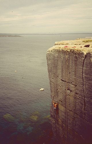
Beecroft Peninsula is the northern headland of Jervis Bay, on Australia's east coast. On the western and southern sides of the peninsula steep sandstone cliffs rise out of the ocean, up to 91 metres at its southernmost point, Point Perpendicular. White sandy beaches are found along the northern, eastern and southern sides interspersed with numerous intertidal reefs.
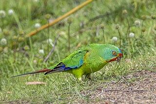
<span class="mw-page-title-main">Swift parrot</span> Critically endangered species of Australian bird

The swift parrot is a species of broad-tailed parrot, found only in southeastern Australia. The species breeds in Tasmania during the summer and migrates north to south eastern mainland Australia from Griffith-Warialda in New South Wales and west to Adelaide in the winter. It is a nomadic migrant, and it settles in an area only when there is food available. The Swift Parrot was voted 2023 Bird of the Year in The Guardian Australia and BirdLife Australia’s biennial poll.

<span class="mw-page-title-main">Painted honeyeater</span> Species of bird

The painted honeyeater is a species of honeyeater in a monotypic genus.

Livingstone is a national park and state conservation area located 30 kilometres (19 mi) south of Wagga Wagga and 10 kilometres (6.2 mi) east of Mangoplah, in the South West Slopes region of south western New South Wales.

<span class="mw-page-title-main">Eastern Australian temperate forests</span> Ecoregion in Australia

The Eastern Australian temperate forests is a broad ecoregion of open forest on uplands starting from the east coast of New South Wales in the South Coast to southern Queensland, Australia. Although dry sclerophyll and wet sclerophyll eucalyptus forests predominate within this ecoregion, a number of distinguishable rainforest communities are present as well.

The Warby-Ovens National Park is a national park located on the lands of the Bangerang clan of the Yorta Yorta Nation in the Hume region of Victoria, Australia near Killawara. The 14,655-hectare (36,210-acre) national park is situated approximately 10 kilometres (6.2 mi) west of Wangaratta and 240 kilometres (150 mi) northeast of Melbourne.

Noosa Biosphere Reserve is an internationally protected area covering the region of Noosa in Queensland, Australia. It is formally recognised as a Biosphere Reserve by the United Nations Education, Scientific and Cultural Organization (UNESCO) and Man and the Biosphere (MAB) program for its highly diverse ecosystem over a relatively small space. It was the first Biosphere Reserve for the state of Queensland, established in September 2007. The reserve is bound by the Noosa Shire Council boundaries, extending offshore by 3 kilometres (1.9 mi), covering 150,000 hectares in total. It is governed by Noosa Biosphere Limited (NBL), a not-for-profit company, which mainly consists of members from the local community who fulfil roles in the governance board, sector boards, and partnerships. Community plays a significant role in the implementation of the Biosphere Reserve guidelines.

The Kangaroo River Nature Reserve, part of the Kangaroo Valley Group of Nature Reserves, is a protected nature reserve that is located on the floor of the Kangaroo Valley in the Southern Highlands and South Coast regions of New South Wales in eastern Australia. The reserve is situated approximately 150 kilometres (93 mi) south of Sydney, 50 kilometres (31 mi) southwest of Wollongong and 16 kilometres (9.9 mi) northwest of Nowra. The reserve has a protective covenant placed upon it with purpose to ensure the protection of the natural heritage of this area. National parks in the area include the Morton National Park and the Budderoo National Park. Other nature reserves in the area include the Barren Grounds Nature Reserve, and the Cambewarra Range, Barrengarry and Rodway nature reserves – the latter three part of the Kangaroo Valley Group of Nature Reserves.

<span class="mw-page-title-main">Charcoal Tank Nature Reserve</span> Protected area in New South Wales, Australia

The Charcoal Tank Nature Reserve is a protected nature reserve in the central western region of New South Wales, Australia. The 86.4-hectare (213-acre) reserve is situated 10 kilometres (6.2 mi) south of West Wyalong and may be accessed via the Newell Highway and The Charcoal Tank Road. The reserve is an important refuge for native flora and fauna in a highly fragmented landscape, one in which the majority of the original vegetation has been removed.

Bangadilly National Park is a national park located around 20 km west of Bowral in the Southern Highlands of New South Wales. Established in 2001, it is made up of three separate, similarly sized areas of land totalling 2,141 hectares in area. It consists of sandstone plateaus and gorges bordering the Wingecarribee River.

<span class="mw-page-title-main">Cumberland Plain Woodland</span> Indigenous woodland community in Sydney, Australia

The Cumberland Plain Woodland, also known as Cumberland Plain Bushland and Western Sydney woodland, is a grassy woodland community found predominantly in Western Sydney, New South Wales, Australia, that comprises an open tree canopy, a groundcover with grasses and herbs, usually with layers of shrubs and/or small trees.

<span class="mw-page-title-main">Limeburners Creek National Park</span> Protected area in New South Wales, Australia

Limeburners Creek National Park is a protected national park on the Mid North Coast of New South Wales, Australia. The 91.2 km national park is located 5 km (3.1 mi) to the north of Port Macquarie and exists across both the Kempsey Shire and Port Macquarie-Hastings Council local government areas, but is chiefly managed by National Parks and Wildlife Service. The area was originally erected as a nature reserve but this reservation was revoked when it became formally recognised as a national park in 2010 under the National Parks and Wildlife Act (1974). Many threatened ecological habitats and species of fauna and flora are found within this park, alongside several heritage sites of cultural significance, particularly to the local Birpai and Dunghutti people upon whose land the park exists. The protected status of this national park is largely owing to the ecological and cultural value of the area, in addition to the value of the ecosystems to further scientific research.

The Jindalee National Park is a protected national park that is located 10 kilometres (6.2 mi) north of Cootamundra, in the South West Slopes region of New South Wales, Australia. The northern boundary of the park runs adjacent to the Burley Griffin Way.

References

  1. 1 2 3 4 5 6 7 8 9 10 11 12 13 14 15 16 Department of Climate Change and Water (NSW) (2010). "Glenrock State Conservation Area Plan of Management". Office of Environment and Heritage - NSW Government. Retrieved 5 May 2015.
  2. Office of Environment and Heritage (NSW) (2012). "Glenrock State Conservation Area Visitor Guide". Office of Environment and Heritage - Department of Premier and Cabinet. Retrieved 5 May 2015.
  3. Kooyman, Robert; Rossetto, Maurizio (2006). "Factors influencing species selection for littoral rainforest restoration: Do environmental gradients matter?". Ecological Management & Restoration. 7 (2): 113–122. Bibcode:2006EcoMR...7..113K. doi:10.1111/j.1442-8903.2006.00265.x. ISSN   1442-7001.
  4. Department of the Environment, Water, Heritage and the Arts (2009). "Littoral Rainforest and Coastal Vine Thickets of Eastern Australia" (PDF). Department of the Environment, Water, Heritage and the Arts - Australian Government. Retrieved 8 May 2015.{{cite web}}: CS1 maint: multiple names: authors list (link)
  5. Gross, C. L. (8 October 2003). "Floral Structure, Breeding System and Fruit-set in the Threatened Sub-shrub Tetratheca juncea Smith (Tremandraceae)". Annals of Botany. 92 (6): 771–777. doi:10.1093/aob/mcg201. ISSN   0305-7364. PMC   4243618 . PMID   14534202.
  6. 1 2 Thurlby, Katie A. G.; Wilson, Peter G.; Sherwin, William B.; Connelly, Carolyn; Rossetto, Maurizio (2012). "Reproductive bet-hedging in a rare yet widespread rainforest tree, Syzygium paniculatum (Myrtaceae)". Austral Ecology. 37 (8): 936–944. Bibcode:2012AusEc..37..936T. doi:10.1111/j.1442-9993.2011.02353.x. ISSN   1442-9985.
  7. BirdLife International. (2018). "Lathamus discolor". IUCN Red List of Threatened Species . 2018: e.T22685219A130886700. doi: 10.2305/IUCN.UK.2018-2.RLTS.T22685219A130886700.en . Retrieved 1 April 2024.
  8. Webb, Matthew H.; Holdsworth, Mark C.; Webb, Janneke (2012). "Nesting requirements of the endangered Swift Parrot ( Lathamus discolor )". Emu - Austral Ornithology. 112 (3): 181–188. Bibcode:2012EmuAO.112..181W. doi:10.1071/MU11014. ISSN   0158-4197.
  9. Heinsohn, Robert; Webb, Matthew; Lacy, Robert; Terauds, Aleks; Alderman, Rachael; Stojanovic, Dejan (2015). "A severe predator-induced population decline predicted for endangered, migratory swift parrots ( Lathamus discolor )". Biological Conservation. 186. Elsevier BV: 75–82. Bibcode:2015BCons.186...75H. doi:10.1016/j.biocon.2015.03.006. ISSN   0006-3207.
  10. Saunders, Debra L.; Heinsohn, Robert (2008). "Winter habitat use by the endangered, migratory Swift Parrot ( Lathamus discolor ) in New South Wales". Emu - Austral Ornithology. 108 (1): 81–89. Bibcode:2008EmuAO.108...81S. doi:10.1071/MU07033. ISSN   0158-4197.
  11. 1 2 BirdLife International. (2018). "Anthochaera phrygia". IUCN Red List of Threatened Species . 2018: e.T22704415A130992272. doi: 10.2305/IUCN.UK.2018-2.RLTS.T22704415A130992272.en . Retrieved 1 April 2024.
  12. Franklin, D.C.; Menkhorst, P.W.; Robinson, J.L. (1989). "Ecology of the Regent Honeyeater Xanthomyza phrygia". Emu - Austral Ornithology. 89 (3): 140–154. Bibcode:1989EmuAO..89..140F. doi:10.1071/MU9890140. ISSN   0158-4197.
  13. Roderick, M. (2013). "Regent Honeyeaters and Eucalypt diversity in the Cessnock area of New South Wales". Australasian Plant Conservation. 22 (2): 9–11. doi:10.5962/p.373514.
  14. Soderquist, Todd; Gibbons, Dale (2007). "Home-range of the Powerful Owl ( Ninox strenua ) in dry sclerophyll forest". Emu - Austral Ornithology. 107 (3): 177–184. Bibcode:2007EmuAO.107..177S. doi:10.1071/MU06055. ISSN   0158-4197.
  15. Tidemann, Christopher R.; Nelson, John E. (2004). "Long-distance movements of the grey-headed flying fox (Pteropus poliocephalus)". Journal of Zoology. 263 (2). Wiley: 141–146. doi:10.1017/s0952836904004960. ISSN   0952-8369.
  16. 1 2 3 Griffin nrm (2003). Glenrock Lagoon Cultural Landscape – Conservation Management and Cultural Tourism Plan. Vol 1 and 2. Report to NSW National Parks and Wildlife Service (Report). Retrieved 4 May 2015.
  17. 1 2 Florence, Ross (2005). "Bell-miner-associated dieback: an ecological perspective". Australian Forestry. 68 (4): 263–266. Bibcode:2005AuFor..68..263F. doi:10.1080/00049158.2005.10674975. ISSN   0004-9158.
  18. 1 2 Jurskis, Vic (2005). "Decline of eucalypt forests as a consequence of unnatural fire regimes". Australian Forestry. 68 (4): 257–262. Bibcode:2005AuFor..68..257J. doi:10.1080/00049158.2005.10674974. ISSN   0004-9158.
  19. National Parks and Wildlife Service (2010). "Glenrock State Conservation Area and Awabakal Nature Reserve Fire Management Strategy". National Parks and Wildlife Service. Retrieved 8 May 2015.
  20. Umwelt Environmental Consultants (2003). "Newcastle Coastline Management Plan. Prepared for Newcastle City Council" (PDF). Archived from the original (PDF) on 21 June 2014. Retrieved 15 May 2015.