Related Research Articles

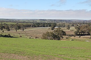
Glenrowan is a town located in the Wangaratta local government area of Victoria, Australia. It is 236 kilometres north-east of Melbourne and 14 kilometres from Wangaratta and near the Warby Ranges and Mount Glenrowan. At the 2021 census, Glenrowan had a population of 1,049.

The Clare Valley wine region is one of Australia's oldest wine regions, best known for Riesling wines. It lies in the Mid North of South Australia, approximately 142 km north of Adelaide. The valley runs north-south, with Horrocks Highway as the main thoroughfare.

The Goulburn Valley is a sub-region, part of the Hume region of the Australian state of Victoria. The sub-region consists of those areas in the catchment of the Goulburn River and other nearby streams, and is part of the Murray-Darling Basin. The Goulburn Valley is bordered on the south by the Great Dividing Range and to the north by the Murray River, the state border with New South Wales. The sub-region is one of Australia's most productive and intensively farmed areas and is predominantly irrigated.

The King Valley, or King River Valley is a wine-producing and agricultural region centred on the King River between Wangaratta and the Alpine National Park in the North East Victoria zone of the Australian state of Victoria. There are several small towns within the region including Cheshunt, Whitfield, King Valley, Edi, Claremont, Moyhu, Byrne, Docker and Oxley. King Valley was recorded as an Australian Geographical Indication protected name on 12 October 2007.
Murray Darling is a wine region and Australian Geographical Indication which spans the Murray River and its confluence with the Darling River in northwestern Victoria and southwestern New South Wales. It was registered as a protected name on 16 June 1997.

The South Australian wine industry is responsible for more than half the production of all Australian wine. South Australia has a vast diversity in geography and climate which allows the state to be able to produce a range of grape varieties–from the cool climate Riesling variety in the Clare Valley wine region to the big, full bodied Shiraz wines of the Barossa Valley.
The Alpine Valleys is an Australian wine region on the western slopes of the Victorian Alps in northeast Victoria. It was registered as an Australian Geographical Indication on 29 November 1999 It is bounded to the west by the King Valley and to the north by the Beechworth wine region. The area is distinctly cooler in climate than some of the other northeast wine regions like Rutherglen. The Alpine Valleys produce grapes primarily for table wine production.
Eden Valley wine region is a wine region located in South Australia immediately north of the capital city of Adelaide which covers an area in the Mount Lofty Ranges extending from Truro in the north to just south of Springton in the south. The region received appellation as an Australian Geographical Indication in 1997 and as of 2014, it is represented by at least 36 wineries.

Fleurieu zone is a wine zone located south of Adelaide in South Australia. It extends from Kangaroo Island in the west as far north as Flagstaff Hill on the west side of the Mount Lofty Ranges and to as far north as Langhorne Creek on the east side of the Mount Lofty Ranges. It consists of the following five wine regions, each of which has received appellation as an Australian Geographical Indication (AGI): Currency Creek, Kangaroo Island, Langhorne Creek, McLaren Vale and the Southern Fleurieu.
Adelaide Plains wine region is a wine region located in South Australia immediately north of the capital city of Adelaide. The region received appellation as an Australian Geographical Indication in 2002 and as of 2014, it is represented by 11 wineries. It is part of the Mount Lofty Ranges zone.

Adelaide Hills is an Australian geographical indication for wine made from grapes grown in a specific area of the Adelaide Hills east of Adelaide in South Australia.

Barossa zone is a wine zone located in central South Australia west of the Murray River and which occupies the Barossa Valley, the Eden Valley and some adjoining land. The zone which is enclosed by the Mount Lofty Ranges zone on three sides and by the Lower Murray zone to its east, contains two wine regions which have received appellation as Australian Geographical Indications (AGI). These are the Barossa Valley and Eden Valley regions. The Barossa zone also includes a broader area around these two defined regions. The zone received AGI in 1996.
Riverina is an Australian Geographical Indication (AGI) registered in the Register of Protected GIs as a wine region. The Riverina AGI is centred on Griffith and is roughly circular with towns on the boundary including Mossgiel, Condobolin, Temora, Junee, Culcairn, Berrigan, Barooga, Finley, Deniliquin and Moulamein. It does not extend as far south as the Murray River. As such, the Riverina wine region is smaller than the generally known Riverina area.
Swan Hill is a wine region name protected by an Australian Geographical Indication (AGI). It is named for the town of Swan Hill on the south side of the Murray River in the Australian state of Victoria. The wine region spans the Murray and the north eastern part of the region is in the state of New South Wales. The north-eastern part of the region is in the New South Wales zone of Big Rivers. The southern and western parts are in the Victoria zone of North West Victoria. The region spans from Lake Charm and Benjeroop in the southeast through Lake Boga and Swan Hill to past Piangil and Tooleybuc in the north.
Gundagai is an Australian Geographical Indication for a wine region centred on the town of Gundagai in the Australian state of New South Wales. It is part of the Southern New South Wales zone. The region includes Tumut on the northwestern slopes of the Snowy Mountains, Cootamundra in its north and extends west to Junee and almost to Wagga Wagga. Junee is on the boundary to the Riverina wine region. Gundagai is also bounded on the northeast by Hilltops, the east by Canberra District and the south by Tumbarumba.
Central Ranges is a wine zone and Australian geographical indication in the Central West of New South Wales. It lies on the western slopes of the Great Dividing Range, west of the Blue Mountains.
Cowra is a wine region and Australian Geographical Indication in the Central Ranges zone in the Australian state of New South Wales. It is named for the town of Cowra.
North East Victoria is an Australian Geographical Indication for a wine zone in the Australian state of Victoria. It includes five named wine regions:

Goulburn Valley wine region is a wine region in the state of Victoria in Australia. It is part of the Central Victoria zone and roughly corresponds to the Goulburn Valley tourist and government region.
The Sunbury wine region is an Australian Geographical Indication for wine made from grapes grown in a region surrounding the town of Sunbury northwest of Melbourne in the Australian state of Victoria. It is one of five regions in the Port Philip zone surrounding Melbourne. The wine region covers suburbs and inner rural areas in the northwestern sector of the Melbourne urban area, extending as far west as Bacchus Marsh and northeast to Beveridge on the Hume Highway.
References
- 1 2 3 Halliday, James. "Glenrowan Wine Region". James Halliday's Wine Atlas of Australia. Archived from the original on 29 January 2018. Retrieved 29 January 2018.
- 1 2 3 "Glenrowan". Discover Australian Wine. Wine Australia. Archived from the original on 29 January 2018. Retrieved 29 January 2018.
- 1 2 "Glenrowan Geographical Indication". Register of Protected GIs and Other Terms / Geographical Indications. Wine Australia. 2016. Archived from the original on 29 January 2018. Retrieved 29 January 2018.
| Central Victoria |  | |
|---|---|---|
| Gippsland | ||
| North East Victoria | ||
| North West Victoria | ||
| Port Phillip | ||
| Western Victoria | ||
| | This wine region article is a stub. You can help Wikipedia by expanding it. |