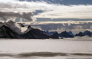
The Hughes Range is a high massive north-south trending mountain range in Antarctica, surmounted by six prominent summits, of which Mount Kaplan is the highest. The range is located east of Canyon Glacier in the Queen Maud Mountains and extends 72 km (45 mi) from the confluence of Brandau and Keltie glaciers in the south, to the Giovinco Ice Piedmont in the north.

The Usarp Mountains is a major Antarctic mountain range, lying westward of the Rennick Glacier and trending N-S for about 190 kilometres (118 mi). The feature is bounded to the north by Pryor Glacier and the Wilson Hills. Its important constituent parts include Welcome Mountain, Mount Van der Hoeven, Mount Weihaupt, Mount Stuart, Mount Lorius, Smith Bench, Mount Roberts, Pomerantz Tableland, Daniels Range, Emlen Peaks, Helliwell Hills and Morozumi Range.
Irwin Glacier is a steep tributary glacier in the Bowers Mountains of Antarctica, draining northeast from Edlin Névé and at the terminus coalescing with Montigny Glacier, with which it enters the larger Graveson Glacier. The glacier was mapped by the United States Geological Survey from surveys and U.S. Navy air photos, 1960–64, and was named by the Advisory Committee on Antarctic Names for Carlisle S. Irwin, a former glaciologist who participated in the study of Meserve Glacier in 1966–67. The glacier lies situated on the Pennell Coast, a portion of Antarctica lying between Cape Williams and Cape Adare.
Arneb Glacier or Hallett Glacier is a glacier 3 nautical miles (6 km) long and 2 nautical miles (4 km) wide, situated in a cliff-walled bay between Hallett Peninsula and Redcastle Ridge and flowing northwest into Edisto Inlet as a floating ice tongue. It was named by the New Zealand Geological Survey Antarctic Expedition, 1957–58, for USS Arneb, which in the 1957 season carried the buildings and stores for the establishment of Hallett Station and revisited the station in subsequent seasons.
Olander Nunatak is one of several somewhat scattered nunataks which rise above the ice of eastern Palmer Land, lying 5 nautical miles (9 km) east of Tollefson Nunatak and 27 nautical miles (50 km) north-northwest of Sky-Hi Nunataks. Mapped by United States Geological Survey (USGS) from surveys and U.S. Navy air photos, 1961-67. Named by Advisory Committee on Antarctic Names (US-ACAN) for R.E. Olander, electronics technician at Eights Station in 1963.
Nils Plain is an ice plain of about 25 nautical miles (46 km) extent, lying northward of Mount Roer in the Sverdrup Mountains, Queen Maud Land. Mapped by Norwegian cartographers from surveys and air photos by Norwegian-British-Swedish Antarctic Expedition (NBSAE) (1949–52) and air photos by the Norwegian expedition (1958–59). Named for Nils Roer, surveyor of the NBSAE.
Coulston Glacier is a small tributary glacier flowing south from the Cartographers Range into Trafalgar Glacier, 10 nautical miles (19 km) west of Bypass Hill, in the Victory Mountains of Victoria Land. It was mapped by the United States Geological Survey from surveys and from U.S. Navy air photos 1960–64, and named by the Advisory Committee on Antarctic Names for Peter W. Coulston, an aviation electronics technician with U.S. Navy Squadron VX-6 at McMurdo Station, 1967.

Eliason Glacier is a glacier 5 nautical miles (9 km) long close west of Mount Hornsby, flowing south from Detroit Plateau into the ice piedmont north of Larsen Inlet, Nordenskjöld Coast in northern Graham Land, Antarctica. It was mapped from surveys by the Falkland Islands Dependencies Survey (1960–61), and was named by the UK Antarctic Place-Names Committee after the Eliason motor sledge, invented in 1942 in Sweden, now made in Canada, and used in Arctic Canada since 1950 and in the Antarctic since 1960.

Festninga Mountain is a broad, ice-topped mountain, 2,535 metres (8,320 ft) high, standing west of Mount Hochlin at the west end of the Mühlig-Hofmann Mountains, in Queen Maud Land, Antarctica. it was mapped by Norwegian cartographers from surveys and air photos by the Sixth Norwegian Antarctic Expedition (1956–60) and named Festninga. Austvollen Bluff forms the east side of the mountain.

Flogeken Glacier is a deeply entrenched glacier, flowing northwest between Mount Grytoyr and Langfloget Cliff, in the Mühlig-Hofmann Mountains of Queen Maud Land, Antarctica. it was mapped by Norwegian cartographers from surveys and air photos by the Sixth Norwegian Antarctic Expedition (1956–60) and named Flogeken.
Glopeneset is a mainly ice-covered promontory at the south side of Glopeflya Plain and the Orvin Mountains in Queen Maud Land, Antarctica. It was first photographed from the air by the Third German Antarctic Expedition (1938–39). It was mapped by Norwegian cartographers from surveys and air photos by the Sixth Norwegian Antarctic Expedition (1956–60) and named Glopeneset.
Hålishalsen Saddle is an ice saddle between the Kurze Mountains and the interior ice plateau close southward, in Queen Maud Land, Antarctica. It was mapped by Norwegian cartographers from surveys and air photos by the Sixth Norwegian Antarctic Expedition (1956–60) and named Hålishalsen.
Mjell Glacier is a glacier 9 nautical miles (17 km) long, flowing northeast between Mount Bergersen and Isachsen Mountain in the Sør Rondane Mountains of Antarctica. It was mapped by Norwegian cartographers in 1957 from air photos taken by U.S. Navy Operation Highjump in 1946–47, and named "Mjellbreen".
Malta Plateau is an ice-covered plateau of about 25 nautical miles (46 km) extent in the Victory Mountains of Victoria Land, Antarctica. The plateau is irregular in shape and is bounded on the south and west by Mariner Glacier, on the north by tributaries to Trafalgar Glacier, and on the east by tributaries to Borchgrevink Glacier. It was named by the New Zealand Antarctic Place-Names Committee to commemorate the island of Malta in association with the Victory Mountains.
Slalåma Slope is a steep ice slope on the northeast side of Borg Mountain, in the Borg Massif of Queen Maud Land. It was mapped by Norwegian cartographers from surveys and air photos by the Norwegian-British-Swedish Antarctic Expedition (NBSAE) (1949–52) and named Slalåma.
Hortebrekka Slope is a crevassed ice slope which marks the eastern edge of Horteriset Dome, just west of the Weyprecht Mountains in Queen Maud Land, Antarctica. It was photographed from the air by the Third German Antarctic Expedition (1938–39), and was mapped and named by Norwegian cartographers from surveys and air photos by the Sixth Norwegian Antarctic Expedition (1956–60).
Kaggen Hill is a small ice-covered hill standing in Byrdbreen, 7 nautical miles (13 km) east of Mount Bergersen in the Sør Rondane Mountains of Antarctica. It was mapped by Norwegian cartographers in 1957 from air photos taken by U.S. Navy Operation Highjump, 1946–47, and named Kaggen.
Rindehallet Slope is an ice slope between Isingen Mountain and Egil Peak in the Sverdrup Mountains, Queen Maud Land. Photographed from the air by the German Antarctic Expedition (1938–39). Mapped by Norwegian cartographers from surveys and air photos by Norwegian-British-Swedish Antarctic Expedition (NBSAE) (1949–52) and air photos by the Norwegian expedition (1958–59) and named Rindehallet.
Rømlingsletta Flat is an ice-covered, flattish area of about 40 square miles, lying northward of the foot of Isingen Mountain, in the Sverdrup Mountains of Queen Maud Land. It was photographed from the air by the German Antarctic Expedition (1938–39) and mapped by Norwegian cartographers from surveys and air photos by the Norwegian-British-Swedish Antarctic Expedition (1949–52) and air photos by the Norwegian expedition (1958–59) and named Rømlingsletta.