Related Research Articles

The River Severn, at 220 miles (354 km) long, is the longest river in Great Britain. It is also the river with the most voluminous flow of water by far in all of England and Wales, with an average flow rate of 107 m3/s (3,800 cu ft/s) at Apperley, Gloucestershire. It rises in the Cambrian Mountains in mid Wales, at an altitude of 2,001 feet (610 m), on the Plynlimon massif, which lies close to the Ceredigion/Powys border near Llanidloes. The river then flows through Shropshire, Worcestershire and Gloucestershire. The county towns of Shrewsbury, Worcester and Gloucester lie on its course.

The Severn bore is a tidal bore seen on the tidal reaches of the River Severn in south western England. It is formed when the rising tide moves into the funnel-shaped Bristol Channel and Severn Estuary and the surging water forces its way upstream in a series of waves, as far as Gloucester and beyond. The bore behaves differently in different stretches of the river; in the lower, wider parts it is more noticeable in the deep channels as a slight roller, while the water creeps across the sand and mudflats. In the narrower, upper reaches, the river occupies the whole area between its banks and the bore advances in a series of waves that move upstream. Near Gloucester, the advancing water overcomes two weirs, and sometimes one in Tewkesbury, before finally petering out.

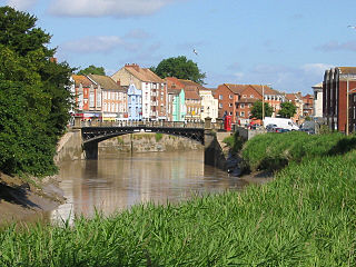
The River Avon is a river in the southwest of England. To distinguish it from a number of other rivers of the same name, it is often called the Bristol Avon. The name 'Avon' is loaned from an ancestor of the Welsh word afon, meaning 'river'.

The Second Severn Crossing, officially named the Prince of Wales Bridge since July 2018, is the M4 motorway bridge over the River Severn between England and Wales, opened in 1996 to supplement the traffic capacity of the Severn Bridge built in 1966. The bridge is operated by England's National Highways. It has a total length of 5,128 metres (16,824 ft).
The Port of London Authority (PLA) is a self-funding public trust established on 31 March 1909 in accordance with the Port of London Act 1908 to govern the Port of London. Its responsibility extends over the Tideway of the River Thames and its continuation. It maintains and supervises navigation, and protects the river's environment.

The Bristol Channel is a major inlet in the island of Great Britain, separating South Wales and South West England. It extends from the smaller Severn Estuary of the River Severn to the North Atlantic Ocean. It takes its name from the English city and port of Bristol.

A pilot boat is a type of boat used to transport maritime pilots between land and the inbound or outbound ships that they are piloting. Pilot boats were once sailing boats that had to be fast because the first pilot to reach the incoming ship got the business. Today, pilot boats are scheduled by telephoning the ship agents/representatives prior to arrival.
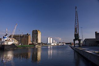
Sharpness is a port in the civil parish of Hinton, in the Stroud district, in Gloucestershire, England, one of the most inland in Britain, and eighth largest in the South West England region. It is on the River Severn at grid reference SO669027, at a point where the tidal range, though less than at Avonmouth downstream, is still large.

The Thames Estuary is where the River Thames meets the waters of the North Sea, in the south-east of Great Britain.

The Severn Estuary is the estuary of the River Severn, flowing into the Bristol Channel between South West England and South Wales. Its very high tidal range, approximately 50 feet (15 m), creates valuable intertidal habitats and has led to the area being at the centre of discussions in the UK regarding renewable tidal energy.
Port of Kolkata or Kolkata Port, officially known as Syama Prasad Mookerjee Port, is the only riverine major port in India, in the city of Kolkata, West Bengal, around 203 kilometres (126 mi) from the sea. It is the oldest operating port in India and was constructed by the British East India Company. Kolkata is a freshwater port with no variation in salinity. The port has two distinct dock systems – Kolkata Dock at Kolkata and a deep water dock at Haldia Dock Complex, Haldia.

The Severn Bridge Railway was a railway company which constructed a railway from Lydney to Sharpness in Gloucestershire, England. It was intended chiefly to give access for minerals in the Forest of Dean to Sharpness Docks, and the company built a long bridge, 1,387 yards (1,268 m) in length, over the River Severn. The line opened in 1879.

The Low Lighthouse is one of three historic lighthouses in Burnham-on-Sea, Somerset, England, and the only one of the three which is still active. It is a Grade II listed building and stands on the foreshore. First lit in 1832, the Low Lighthouse operated in conjunction with the (onshore) High Lighthouse for 137 years. Then, in 1969 the Low Lighthouse was deactivated; but later, in 1993, the Low Lighthouse was re-established and the High Lighthouse was instead decommissioned).

Mayflower is a steam tug built in Bristol in 1861 and now preserved by Bristol Museums Galleries & Archives. She is based in Bristol Harbour at M Shed. She is the oldest Bristol-built ship afloat, and is believed to be the oldest surviving tug in the world.
The Port of Bridgwater is a port, originally located in the town of Bridgwater, Somerset, England. Created under the Bridgwater Navigation and Quays Act 1845 it extends from Brean Down to Hinkley Point in Bridgwater Bay, and parts of the rivers Parrett, River Brue and River Axe. Although no ships now dock in the town, in 2001 103,613 (metric) tonnes of cargo were handled within the area of the Port Authority, most of which were stone products through the wharf at Dunball.

The United Kingdom's Pilotage Act 1987 is an Act of Parliament that governs the operation of maritime pilotage. The Act repealed the previous pilotage legislation in its entirety, the Pilotage Act 1983, which itself had repealed the Pilotage Act 1913.

A Bristol Channel pilot cutter is a type of sailing boat used until the early part of the 20th century to deliver and collect pilots to and from merchant vessels using ports in the Bristol Channel. Each pilot worked individually, in competition with other pilots. Especially after 1861, the level of competition required larger and faster cutters, as pilots went "seeking" at much greater distances. The resulting boats were known for their ability to sail in the most extreme weather, for speed and sea-kindliness. They were designed for short handed sailing, often manned only by a man and an apprentice, with one or sometimes two pilots on board.
Competent harbour authorities (CHA) in the United Kingdom are those harbour authorities that have been given statutory powers relating to the provision of pilotage in their waters. The description was created by the Pilotage Act 1987, at which point a CHA had to be one whose harbour was wholly or partly within a pilotage district where at least one act of pilotage had been performed, or where a pilotage exemption certificate had been in force, between 1984 and 1987. However, the act provided a procedure by which other harbour authorities could be assigned CHA status and some harbours have taken advantage of this process. The Marine Navigation Act 2013 amended the Pilotage Act to provide a reverse process, so that harbour authorities could be relieved of CHA status.
References
- 1 2 "GHT: Limits of the Gloucester Harbour" (PDF). Archived from the original (PDF) on 27 May 2014.
- 1 2 Conway-Jones, Hugh (2013). The Gloucester And Sharpness Canal Through Time. Amberley Publishing Limited. p. 250. ISBN 978-1-4456-2580-5.
- 1 2 Dobrzynski, Jan (2016). River Severn: From Source to Sea. Amberley Publishing Limited. p. 164. ISBN 978-1-4456-4905-4.
- ↑ "Severn Bore guidance" (PDF). Gloucester Harbour Trustees. Archived from the original (PDF) on 4 March 2016. Retrieved 27 August 2016.