The River Severn, at 220 miles (354 km) long, is the longest river in Great Britain. It is also the river with the most voluminous flow of water by far in all of England and Wales, with an average flow rate of 107 m3/s (3,800 cu ft/s) at Apperley, Gloucestershire. It rises in the Cambrian Mountains in mid Wales, at an altitude of 2,001 feet (610 m), on the Plynlimon massif, which lies close to the Ceredigion/Powys border near Llanidloes. The river then flows through Shropshire, Worcestershire and Gloucestershire. The county towns of Shrewsbury, Worcester and Gloucester lie on its course.

The River Avon is a river in the southwest of England. To distinguish it from a number of other rivers of the same name, it is often called the Bristol Avon. The name 'Avon' is loaned from an ancestor of the Welsh word afon, meaning 'river'.

The Second Severn Crossing, officially named the Prince of Wales Bridge since July 2018, is the M4 motorway bridge over the River Severn between England and Wales, opened in 1996 to supplement the traffic capacity of the Severn Bridge built in 1966. The bridge is operated by England's National Highways. It has a total length of 5,128 metres (16,824 ft).

The Bristol Channel is a major inlet in the island of Great Britain, separating South Wales and South West England. It extends from the smaller Severn Estuary of the River Severn to the North Atlantic Ocean. It takes its name from the English city and port of Bristol.

Portishead is a town and civil parish in the North Somerset unitary authority area, in the county of Somerset, England. With a population of 26,366 at the 2021 Census, the town is located on the Severn Estuary opposite Cardiff and Newport in Wales. The town is 8 miles (13 km) to the west of Bristol and 18 miles northeast of Weston-super-Mare.
Avonmouth is a port and outer suburb of Bristol, England, on the north bank of the mouth of the River Avon and the eastern shore of the Severn Estuary. Part of the Port of Bristol, Avonmouth Docks is important to the region's maritime economy, hosting large vessels for the unloading and exporting of heavier goods. Much of the land use is industrial, including warehousing, light industry, electrical power and sanitation. The M5 motorway bisects the neighbourhood, with junctions onto the A4 road and M49 motorway, and it has stations on the Severn Beach Line railway.
The Avon Gorge is a 1.5-mile (2.5-kilometre) long gorge on the River Avon in Bristol, England. The gorge runs south to north through a limestone ridge 1.5 miles (2.4 km) west of Bristol city centre, and about 3 miles (5 km) from the mouth of the river at Avonmouth. The gorge forms the boundary between the unitary authorities of North Somerset and Bristol, with the boundary running along the south bank. As Bristol was an important port, the gorge formed a defensive gateway to the city.

The Thames Estuary is where the River Thames meets the waters of the North Sea, in the south-east of Great Britain.

The Severn Estuary is the estuary of the River Severn, flowing into the Bristol Channel between South West England and South Wales. Its very high tidal range, approximately 50 feet (15 m), creates valuable intertidal habitats and has led to the area being at the centre of discussions in the UK regarding renewable tidal energy.

The Severn Barrage is any of a range of ideas for building a barrage from the English coast to the Welsh coast over the Severn tidal estuary. Ideas for damming or barraging the Severn estuary have existed since the 19th century. The building of such a barrage would constitute an engineering project comparable with some of the world's biggest. The purposes of such a project have typically been one or several of: transport links, flood protection, harbour creation, or tidal power generation. In recent decades it is the latter that has grown to be the primary focus for barrage ideas, and the others are now seen as useful side-effects. Following the Severn Tidal Power Feasibility Study (2008–10), the British government concluded that there was no strategic case for building a barrage but to continue to investigate emerging technologies. In June 2013 the Energy and Climate Change Select Committee published its findings after an eight-month study of the arguments for and against the Barrage. MPs said the case for the barrage was unproven. They were not convinced the economic case was strong enough and said the developer, Hafren Power, had failed to answer serious environmental and economic concerns.
Goldcliff is a village, parish and community to the south east of the city of Newport in South Wales. It lies within the Newport city boundaries in the historic county of Monmouthshire and the preserved county of Gwent. Administratively, the community of Goldcliff includes the village/parish of Whitson. The population in 2001 was 233; by 2011 it had risen to 329.
New Passage is a hamlet in South Gloucestershire, England, on the banks of the Severn estuary near the village of Pilning. It takes its name from the ferry service which operated between there and South Wales until 1886.
The Gloucester Harbour Trustees are the competent harbour authority (CHA) for the tidal part of the River Severn from the Gloucester weirs down to seaward of the Second Severn Crossing, on the Welsh side of the Severn Estuary from the Second Severn Crossing as far as Goldcliff, and on the River Wye up to its tidal limit (Bigsweir).

Portskewett is a village and community (parish) in Monmouthshire, south east Wales. It is located four miles south west of Chepstow and one mile east of Caldicot, in an archaeologically sensitive part of the Caldicot Levels on the Welsh shore of the Severn Estuary. The Second Severn Crossing passes overhead carrying the M4 motorway. The community includes Sudbrook, Crick and Leechpool.
The geographical term Severnside refers to an area adjoining or straddling the River Severn or its estuary in Great Britain.
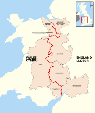
The England–Wales border, sometimes referred to as the Wales–England border or the Anglo-Welsh border, runs for 160 miles (260 km) from the Dee estuary, in the north, to the Severn estuary in the south, separating England and Wales.

Portbury Ashlands which is now known as Portbury Wharf Nature Reserve is a nature reserve between Portishead and the Royal Portbury Dock in Somerset, England. It was formed from the redevelopment of the area of Portishead formerly occupied by two power stations. To the east of the harbour, an area known as "the Ashlands" was used for over 50 years to get rid of power station waste which was dumped into lagoons on the site.

Black Nore Lighthouse at Portishead, Somerset, England, was built in 1894. It is a Grade II listed building.
The Gordano Round is a 27-mile (43 km) recreational Long-distance trail, running as a figure of eight around the Gordano Valley near Portishead in North Somerset, England.

The coastline of Wales extends from the English border at Chepstow westwards to Pembrokeshire then north to Anglesey and back eastwards to the English border once again near Flint. Its character is determined by multiple factors, including the local geology and geological processes active during and subsequent to the last ice age, its relative exposure to or shelter from waves, tidal variation and the history of human settlement and development which varies considerably from one place to another. The majority of the coast east of Cardiff in the south, and of Llandudno in the north, is flat whilst that to the west is more typically backed by cliffs. The cliffs are a mix of sandstones, shales and limestones, the erosion of which provides material for beach deposits. Of the twenty-two principal areas which deliver local government in Wales, sixteen have a coastline, though that of Powys consists only of a short section of tidal river some distance from the open sea. Its length has been estimated at 1,680 miles (2,700 km).