Wadowice County is a unit of territorial administration and local government (powiat) in Lesser Poland Voivodeship, southern Poland. It came into being on January 1, 1999, as a result of the Polish local government reforms passed in 1998. Its administrative seat is the town of Wadowice, the birthplace of Pope John Paul II, which lies 38 kilometres (24 mi) south-west of the regional capital Kraków. The county also contains the towns of Andrychów, lying 13 km (8 mi) west of Wadowice, and Kalwaria Zebrzydowska, 14 km (9 mi) east of Wadowice.

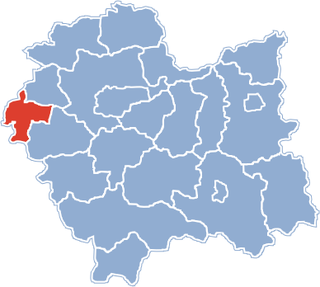
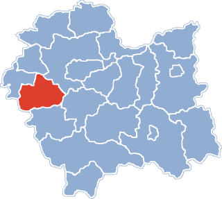
Chrzanów County is a unit of territorial administration and local government (powiat) in Lesser Poland Voivodeship, southern Poland. It came into being on January 1, 1999, as a result of the Polish local government reforms passed in 1998. Its administrative seat and largest town is Chrzanów, which lies 40 kilometres (25 mi) west of the regional capital Kraków. The county contains three other towns: Trzebinia, 8 km (5 mi) north-east of Chrzanów, Libiąż, 8 km (5 mi) south-west of Chrzanów, and Alwernia, 12 km (7 mi) south-east of Chrzanów.
Bieruń-Lędziny County is a unit of territorial administration and local government (powiat) in Silesian Voivodeship, southern Poland. It came into being on January 1, 1999, as a result of the Polish local government reforms passed in 1998. Its administrative seat and largest town is Bieruń, which lies 15 kilometres (9 mi) south-east of the regional capital Katowice. The county also contains the towns of Lędziny, lying 2 km (1 mi) south-east of Bieruń, and Imielin, 7 km (4 mi) east of Bieruń.
Gmina Ścinawa is an urban-rural gmina in Lubin County, Lower Silesian Voivodeship, in south-western Poland. Its seat is the town of Ścinawa, which lies approximately 16 kilometres (10 mi) east of Lubin, and 54 kilometres (34 mi) north-west of the regional capital Wrocław.
Gmina Nowa Sól is a rural gmina in Nowa Sól County, Lubusz Voivodeship, in western Poland. Its seat is the town of Nowa Sól, although the town is not part of the territory of the gmina.
Gmina Libiąż is an urban-rural gmina in Chrzanów County, Lesser Poland Voivodeship, in southern Poland. Its seat is the town of Libiąż, which lies approximately 8 kilometres (5 mi) south-west of Chrzanów and 45 km (28 mi) west of the regional capital Kraków.
Gmina Brzeszcze is an urban-rural gmina in Oświęcim County, Lesser Poland Voivodeship, in southern Poland. Its seat is the town of Brzeszcze, which lies approximately 9 kilometres (6 mi) south-west of Oświęcim and 57 km (35 mi) west of the regional capital Kraków.
Gmina Kęty is an urban-rural gmina in Oświęcim County, Lesser Poland Voivodeship, in southern Poland. Its seat is the town of Kęty, which lies approximately 17 kilometres (11 mi) south of Oświęcim and 55 km (34 mi) west of the regional capital Kraków.
Gmina Osiek is a rural gmina in Oświęcim County, Lesser Poland Voivodeship, in southern Poland. Its seat is the village of Osiek; it also contains the village of Głębowice.
Gmina Oświęcim is a rural gmina in Oświęcim County, Lesser Poland Voivodeship, in southern Poland. Its seat is the town of Oświęcim, although the town is not part of the territory of the gmina.
Gmina Polanka Wielka is a rural gmina in Oświęcim County, Lesser Poland Voivodeship, in southern Poland. Its seat is the village of Polanka Wielka, which lies approximately 10 kilometres (6 mi) south-east of Oświęcim and 46 km (29 mi) west of the regional capital Kraków.
Gmina Przeciszów is a rural gmina in Oświęcim County, Lesser Poland Voivodeship, in southern Poland. Its seat is the village of Przeciszów, which lies approximately 12 kilometres (7 mi) east of Oświęcim and 40 km (25 mi) west of the regional capital Kraków.
Gmina Zator is an urban-rural gmina in Oświęcim County, Lesser Poland Voivodeship, in southern Poland. Its seat is the town of Zator, which lies approximately 16 kilometres (10 mi) east of Oświęcim and 37 km (23 mi) west of the regional capital Kraków.
Gmina Stegna is a rural gmina in Nowy Dwór Gdański County, Pomeranian Voivodeship, in northern Poland. Its seat is the village of Stegna, which lies approximately 13 kilometres (8 mi) north of Nowy Dwór Gdański and 32 km (20 mi) east of the regional capital Gdańsk.
Gmina Bojszowy is a rural gmina in Bieruń-Lędziny County, Silesian Voivodeship, in southern Poland. Its seat is the village of Bojszowy, which lies approximately 8 kilometres (5 mi) south of Bieruń and 22 km (14 mi) south of the regional capital Katowice.
Gmina Chełm Śląski is a rural gmina in Bieruń-Lędziny County, Silesian Voivodeship, in southern Poland. Its seat is the village of Chełm Śląski, which lies approximately 8 kilometres (5 mi) east of Bieruń and 21 km (13 mi) south-east of the regional capital Katowice. The gmina also contains the villages of Chełm Mały and Kopciowice.
Gmina Miedźna is a rural gmina in Pszczyna County, Silesian Voivodeship, in southern Poland. Its seat is the village of Miedźna, which lies approximately 8 kilometres (5 mi) east of Pszczyna and 30 km (19 mi) south of the regional capital Katowice.

Gmina Doruchów is a rural gmina in Ostrzeszów County, Greater Poland Voivodeship, in west-central Poland. Its seat is the village of Doruchów, which lies approximately 7 kilometres (4 mi) east of Ostrzeszów and 136 km (85 mi) south-east of the regional capital Poznań.