Gmina Jedwabno

Last updated
Gmina Jedwabno
Jedwabno Commune
Gmina
POL gmina Jedwabno flag.svg
Flag
POL gmina Jedwabno COA.svg
Coat of arms
Coordinates(Jedwabno): 53°31′47″N20°43′47″E / 53.52972°N 20.72972°E / 53.52972; 20.72972
CountryFlag of Poland.svg  Poland
Voivodeship Warmian-Masurian
County Szczytno
Seat Jedwabno
Area
  Total 311.51 km2 (120.27 sq mi)
Population (2006)
  Total 3,561
  Density 11/km2 (30/sq mi)
Website http://www.jedwabno.com

Gmina Jedwabno is a rural gmina (administrative district) in Szczytno County, Warmian-Masurian Voivodeship, in northern Poland. Its seat is the village of Jedwabno, which lies approximately 18 kilometres (11 mi) west of Szczytno and 32 km (20 mi) south-east of the regional capital Olsztyn.

Gmina administrative division of Poland

The gmina is the principal unit of the administrative division of Poland, similar to a municipality. As of 2010 there were 2,478 gminy throughout the country. The word gmina derives from the German word Gemeinde, meaning "community".

Szczytno County County in Warmian-Masurian, Poland

Szczytno County is a unit of territorial administration and local government (powiat) in Warmian-Masurian Voivodeship, northern Poland. It came into being on January 1, 1999, as a result of the Polish local government reforms passed in 1998. Its administrative seat and largest town is Szczytno, which lies 45 kilometres (28 mi) south-east of the regional capital Olsztyn. The only other town in the county is Pasym, lying 18 km (11 mi) north-west of Szczytno.

Warmian-Masurian Voivodeship Voivodeship in Poland

Warmian-Masurian Voivodeship or Warmia-Masuria Province or Warmia-Mazury Province, is a voivodeship (province) in northeastern Poland. Its capital and largest city is Olsztyn. The voivodeship has an area of 24,192 km2 (9,341 sq mi) and a population of 1,427,091.

Contents

The gmina covers an area of 311.51 square kilometres (120.3 sq mi), and as of 2006 its total population is 3,561.

Villages

Gmina Jedwabno contains the villages and settlements of Brajniki, Burdąg, Czarny Piec, Dębowiec, Dłużek, Dzierzki, Kot, Lipniki, Małszewo, Narty, Nowe Borowe, Nowy Dwór, Nowy Las, Piduń, Rekownica, Szuć, Waplewo, Warchały, Witówko and Witowo.

Brajniki Village in Warmian-Masurian, Poland

Brajniki is a village in the administrative district of Gmina Jedwabno, within Szczytno County, Warmian-Masurian Voivodeship, in northern Poland. It lies approximately 12 kilometres (7 mi) west of Szczytno and 32 km (20 mi) south-east of the regional capital Olsztyn.

Burdąg Village in Warmian-Masurian, Poland

Burdąg is a village in the administrative district of Gmina Jedwabno, within Szczytno County, Warmian-Masurian Voivodeship, in northern Poland.

Czarny Piec Village in Warmian-Masurian, Poland

Czarny Piec is a village in the administrative district of Gmina Jedwabno, within Szczytno County, Warmian-Masurian Voivodeship, in northern Poland. It lies approximately 24 kilometres (15 mi) west of Szczytno and 25 km (16 mi) south of the regional capital Olsztyn.

Neighbouring gminas

Gmina Jedwabno is bordered by the gminas of Janowo, Nidzica, Olsztynek, Pasym, Purda, Szczytno and Wielbark.

Gmina Janowo is a rural gmina in Nidzica County, Warmian-Masurian Voivodeship, in northern Poland. Its seat is the village of Janowo, which lies approximately 17 kilometres (11 mi) east of Nidzica and 53 km (33 mi) south of the regional capital Olsztyn.

Gmina Nidzica is an urban-rural gmina in Nidzica County, Warmian-Masurian Voivodeship, in northern Poland. Its seat is the town of Nidzica, which lies approximately 48 kilometres (30 mi) south of the regional capital Olsztyn.

Gmina Olsztynek is an urban-rural gmina in Olsztyn County, Warmian-Masurian Voivodeship, in northern Poland. Its seat is the town of Olsztynek, which lies approximately 27 kilometres (17 mi) south-west of the regional capital Olsztyn.

Related Research Articles

Gmina Wielbark is a rural gmina in Szczytno County, Warmian-Masurian Voivodeship, in northern Poland. Its seat is the village of Wielbark, which lies approximately 19 kilometres (12 mi) south of Szczytno and 52 km (32 mi) south-east of the regional capital Olsztyn.

Szuć Village in Warmian-Masurian, Poland

Szuć is a village in the administrative district of Gmina Jedwabno, within Szczytno County, Warmian-Masurian Voivodeship, in northern Poland. It lies approximately 18 kilometres (11 mi) west of Szczytno and 35 km (22 mi) south-east of the regional capital Olsztyn.

Wola Błędowska, Nowy Dwór Mazowiecki County Village in Masovian, Poland

Wola Błędowska is a village in the administrative district of Gmina Pomiechówek, within Nowy Dwór Mazowiecki County, Masovian Voivodeship, in east-central Poland. It lies approximately 10 kilometres (6 mi) north-west of Brody-Parcele, 12 km (7 mi) north of Nowy Dwór Mazowiecki, and 43 km (27 mi) north-west of Warsaw.

Dębowiec, Szczytno County Village in Warmian-Masurian, Poland

Dębowiec is a village in the administrative district of Gmina Jedwabno, within Szczytno County, Warmian-Masurian Voivodeship, in northern Poland. It lies approximately 20 kilometres (12 mi) south-west of Szczytno and 37 km (23 mi) south-east of the regional capital Olsztyn.

Dłużek, Warmian-Masurian Voivodeship Village in Warmian-Masurian, Poland

Dłużek is a village in the administrative district of Gmina Jedwabno, within Szczytno County, Warmian-Masurian Voivodeship, in northern Poland. It lies approximately 4 kilometres (2 mi) north-west of Jedwabno, 21 km (13 mi) west of Szczytno, and 29 km (18 mi) south-east of the regional capital Olsztyn.

Dzierzki Village in Warmian-Masurian, Poland

Dzierzki is a village in the administrative district of Gmina Jedwabno, within Szczytno County, Warmian-Masurian Voivodeship, in northern Poland. It lies approximately 9 kilometres (6 mi) west of Szczytno and 35 km (22 mi) south-east of the regional capital Olsztyn.

Kot, Warmian-Masurian Voivodeship Village in Warmian-Masurian, Poland

Kot is a village in the administrative district of Gmina Jedwabno, within Szczytno County, Warmian-Masurian Voivodeship, in northern Poland. It lies approximately 7 kilometres (4 mi) south-west of Jedwabno, 23 km (14 mi) south-west of Szczytno, and 36 km (22 mi) south of the regional capital Olsztyn.

Małszewo Village in Warmian-Masurian, Poland

Małszewo is a village in the administrative district of Gmina Jedwabno, within Szczytno County, Warmian-Masurian Voivodeship, in northern Poland. It lies approximately 5 kilometres (3 mi) north-west of Jedwabno, 19 km (12 mi) west of Szczytno, and 28 km (17 mi) south-east of the regional capital Olsztyn.

Narty, Warmian-Masurian Voivodeship Village in Warmian-Masurian, Poland

Narty is a village in the administrative district of Gmina Jedwabno, within Szczytno County, Warmian-Masurian Voivodeship, in northern Poland. It lies approximately 5 kilometres (3 mi) north-east of Jedwabno, 14 km (9 mi) west of Szczytno, and 32 km (20 mi) south-east of the regional capital Olsztyn.

Nowe Borowe Village in Warmian-Masurian, Poland

Nowe Borowe is a village in the administrative district of Gmina Jedwabno, within Szczytno County, Warmian-Masurian Voivodeship, in northern Poland. It lies approximately 23 kilometres (14 mi) west of Szczytno and 34 km (21 mi) south of the regional capital Olsztyn.

Nowy Dwór, Szczytno County Village in Warmian-Masurian, Poland

Nowy Dwór is a village in the administrative district of Gmina Jedwabno, within Szczytno County, Warmian-Masurian Voivodeship, in northern Poland. It lies approximately 10 kilometres (6 mi) west of Szczytno and 34 km (21 mi) south-east of the regional capital Olsztyn.

Nowy Las, Warmian-Masurian Voivodeship Village in Warmian-Masurian, Poland

Nowy Las is a village in the administrative district of Gmina Jedwabno, within Szczytno County, Warmian-Masurian Voivodeship, in northern Poland. It lies approximately 7 kilometres (4 mi) south-west of Jedwabno, 23 km (14 mi) west of Szczytno, and 34 km (21 mi) south of the regional capital Olsztyn.

Rekownica, Warmian-Masurian Voivodeship Village in Warmian-Masurian, Poland

Rekownica is a village in the administrative district of Gmina Jedwabno, within Szczytno County, Warmian-Masurian Voivodeship, in northern Poland. It lies approximately 8 kilometres (5 mi) south-east of Jedwabno, 15 km (9 mi) south-west of Szczytno, and 40 km (25 mi) south-east of the regional capital Olsztyn.

Waplewo, Szczytno County Village in Warmian-Masurian, Poland

Waplewo is a village in the administrative district of Gmina Jedwabno, within Szczytno County, Warmian-Masurian Voivodeship, in northern Poland. It lies approximately 8 kilometres (5 mi) north of Jedwabno, 17 km (11 mi) west of Szczytno, and 27 km (17 mi) south-east of the regional capital Olsztyn.

Warchały Village in Warmian-Masurian, Poland

Warchały is a village in the administrative district of Gmina Jedwabno, within Szczytno County, Warmian-Masurian Voivodeship, in northern Poland. It lies approximately 12 kilometres (7 mi) west of Szczytno and 34 km (21 mi) south-east of the regional capital Olsztyn.

Witówko Village in Warmian-Masurian, Poland

Witówko is a village in the administrative district of Gmina Jedwabno, within Szczytno County, Warmian-Masurian Voivodeship, in northern Poland. It lies approximately 7 kilometres (4 mi) west of Szczytno and 37 km (23 mi) south-east of the regional capital Olsztyn.

Witowo, Warmian-Masurian Voivodeship Village in Warmian-Masurian, Poland

Witowo is a village in the administrative district of Gmina Jedwabno, within Szczytno County, Warmian-Masurian Voivodeship, in northern Poland. It lies approximately 7 kilometres (4 mi) north-east of Jedwabno, 13 km (8 mi) west of Szczytno, and 31 km (19 mi) south-east of the regional capital Olsztyn.
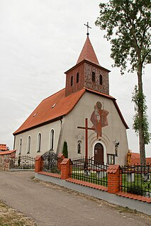
Jedwabno, Warmian-Masurian Voivodeship Village in Warmian-Masurian, Poland

Jedwabno is a village in Szczytno County, Warmian-Masurian Voivodeship, in northern Poland. It is the seat of the administrative district of Gmina Jedwabno. It lies approximately 18 kilometres (11 mi) west of Szczytno and 32 km (20 mi) south-east of the regional capital Olsztyn.

References

Coordinates: 53°31′47″N20°43′47″E / 53.52972°N 20.72972°E / 53.52972; 20.72972

Geographic coordinate system Coordinate system

A geographic coordinate system is a coordinate system that enables every location on Earth to be specified by a set of numbers, letters or symbols. The coordinates are often chosen such that one of the numbers represents a vertical position and two or three of the numbers represent a horizontal position; alternatively, a geographic position may be expressed in a combined three-dimensional Cartesian vector. A common choice of coordinates is latitude, longitude and elevation. To specify a location on a plane requires a map projection.