Gmina Przemęt

Last updated
Gmina Przemęt
Przemęt Commune
Gmina
POL gmina Przemet COA.svg
Coat of arms
Poland adm location map.svg
Red pog.svg
Gmina Przemęt
Location within Poland
Coordinates(Przemęt): 52°1′N16°18′E / 52.017°N 16.300°E / 52.017; 16.300 Coordinates: 52°1′N16°18′E / 52.017°N 16.300°E / 52.017; 16.300
CountryFlag of Poland.svg  Poland
Voivodeship Greater Poland
County Wolsztyn
Seat Przemęt
Area
  Total 225.31 km2 (86.99 sq mi)
Population (2011) [1]
  Total 13,837
  Density 61/km2 (160/sq mi)
Website www.przemet.pl

Gmina Przemęt is a rural gmina (administrative district) in Wolsztyn County, Greater Poland Voivodeship, in west-central Poland. Its seat is the village of Przemęt, which lies approximately 17 kilometres (11 mi) south-east of Wolsztyn and 60 km (37 mi) south-west of the regional capital Poznań.

Gmina administrative division of Poland

The gmina is the principal unit of the administrative division of Poland, similar to a municipality. As of 2010 there were 2,478 gminy throughout the country. The word gmina derives from the German word Gemeinde, meaning "community".

Wolsztyn County County in Greater Poland, Poland

Wolsztyn County is a unit of territorial administration and local government (powiat) in Greater Poland Voivodeship, west-central Poland. It came into being on January 1, 1999, as a result of the Polish local government reforms passed in 1998. Its administrative seat and only town is Wolsztyn, which lies 63 kilometres (39 mi) south-west of the regional capital Poznań.

Greater Poland Voivodeship Voivodeship in Poland

Greater Poland Voivodeship, also known as Wielkopolska Voivodeship, Wielkopolska Province, or Greater Poland Province, is a voivodeship, or province, in west-central Poland. It was created on 1 January 1999 out of the former Poznań, Kalisz, Konin, Piła and Leszno Voivodeships, pursuant to the Polish local government reforms adopted in 1998. The province is named after the region called Greater Poland or Wielkopolska(listen). The modern province includes most of this historic region, except for some south-western parts.

Contents

The gmina covers an area of 225.31 square kilometres (87.0 sq mi), and as of 2006 its total population was 13,494 (13,187 in 2011).

The gmina contains part of the protected area called Przemęt Landscape Park.

Protected area location which receives protection because of its recognised natural, ecological or cultural landscape values

Protected areas or conservation areas are locations which receive protection because of their recognized natural, ecological or cultural values. There are several kinds of protected areas, which vary by level of protection depending on the enabling laws of each country or the regulations of the international organizations involved.

Przemęt Landscape Park

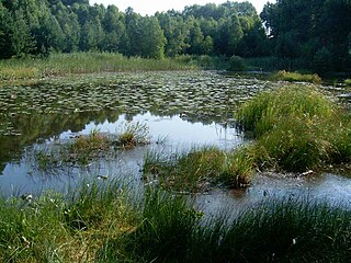
Przemęt Landscape Park is a protected area in western Poland, established in 1991, covering an area of 214.50 square kilometres (82.82 sq mi).

Villages

Gmina Przemęt contains the villages and settlements of Barchlin, Biskupice, Błotnica, Borek, Bucz, Bucz Dębina, Bucz Nowy, Górsko, Kaszczor, Kluczewo, [Mochy], Nowa Wieś, Olejnica, Osłonin, Perkowo, Popowo Stare, Poświętno, Przemęt, Radomierz, Sączkowo, Siekówko, Siekowo, Sokołowice, Solec, Solec Nowy, Starkowo, Wieleń Zaobrzański and Wincentowo.

Barchlin Village in Greater Poland, Poland

Barchlin is a village in the administrative district of Gmina Przemęt, within Wolsztyn County, Greater Poland Voivodeship, in west-central Poland. It lies approximately 7 kilometres (4 mi) east of Przemęt, 23 km (14 mi) south-east of Wolsztyn, and 56 km (35 mi) south-west of the regional capital Poznań.

Biskupice, Wolsztyn County Village in Greater Poland, Poland

Biskupice is a village in the administrative district of Gmina Przemęt, within Wolsztyn County, Greater Poland Voivodeship, in west-central Poland. It lies approximately 9 kilometres (6 mi) south-east of Przemęt, 26 km (16 mi) south-east of Wolsztyn, and 58 km (36 mi) south-west of the regional capital Poznań.

Błotnica, Greater Poland Voivodeship Village in Greater Poland, Poland

Błotnica is a village in the administrative district of Gmina Przemęt, within Wolsztyn County, Greater Poland Voivodeship, in west-central Poland. It lies approximately 2 kilometres (1 mi) south of Przemęt, 19 km (12 mi) south-east of Wolsztyn, and 62 km (39 mi) south-west of the regional capital Poznań.

Neighbouring gminas

Gmina Przemęt is bordered by the gminas of Rakoniewice, Sława, Śmigiel, Wielichowo, Wijewo, Włoszakowice and Wolsztyn.

Gmina Rakoniewice is an urban-rural gmina in Grodzisk Wielkopolski County, Greater Poland Voivodeship, in west-central Poland. Its seat is the town of Rakoniewice, which lies approximately 13 kilometres (8 mi) south-west of Grodzisk Wielkopolski and 53 km (33 mi) south-west of the regional capital Poznań.

Gmina Sława is an urban-rural gmina in Wschowa County, Lubusz Voivodeship, in western Poland. Its seat is the town of Sława, which lies approximately 18 kilometres (11 mi) north-west of Wschowa and 41 km (25 mi) east of Zielona Góra.

Gmina Śmigiel is an urban-rural gmina in Kościan County, Greater Poland Voivodeship, in west-central Poland. Its seat is the town of Śmigiel, which lies approximately 13 kilometres (8 mi) south-west of Kościan and 52 km (32 mi) south-west of the regional capital Poznań.

Related Research Articles

Gmina Nowy Korczyn Gmina in Świętokrzyskie, Poland

Gmina Nowy Korczyn is a rural gmina in Busko County, Świętokrzyskie Voivodeship, in south-central Poland. Its seat is the village of Nowy Korczyn, which lies approximately 20 kilometres (12 mi) south of Busko-Zdrój and 67 km (42 mi) south of the regional capital Kielce.

Gmina Pacanów is a rural gmina in Busko County, Świętokrzyskie Voivodeship, in south-central Poland. Its seat is the village of Pacanów, which lies approximately 25 kilometres (16 mi) east of Busko-Zdrój and 62 km (39 mi) south-east of the regional capital Kielce.

Gmina Solec-Zdrój is a rural gmina in Busko County, Świętokrzyskie Voivodeship, in south-central Poland. Its seat is the village of Solec-Zdrój, which lies approximately 17 kilometres (11 mi) south-east of Busko-Zdrój and 61 km (38 mi) south of the regional capital Kielce.

Gmina Wolsztyn is an urban-rural gmina in Wolsztyn County, Greater Poland Voivodeship, in west-central Poland. Its seat is the town of Wolsztyn, which lies approximately 63 kilometres (39 mi) south-west of the regional capital Poznań.

Gmina Siedlec Gmina in Greater Poland, Poland

Gmina Siedlec is a rural gmina in Wolsztyn County, Greater Poland Voivodeship, in west-central Poland. Its seat is the village of Siedlec, which lies approximately 8 kilometres (5 mi) west of Wolsztyn and 69 km (43 mi) south-west of the regional capital Poznań.

Bucz Village in Greater Poland, Poland

Bucz is a village in the administrative district of Gmina Przemęt, within Wolsztyn County, Greater Poland Voivodeship, in west-central Poland. It lies approximately 8 kilometres (5 mi) east of Przemęt, 24 km (15 mi) south-east of Wolsztyn, and 57 km (35 mi) south-west of the regional capital Poznań.

Bucz Dębina, Wolsztyn County Settlement in Greater Poland, Poland

Bucz Dębina is a settlement in the administrative district of Gmina Przemęt, within Wolsztyn County, Greater Poland Voivodeship, in west-central Poland. It lies approximately 5 kilometres (3 mi) south-east of Przemęt, 22 km (14 mi) south-east of Wolsztyn, and 59 km (37 mi) south-west of the regional capital Poznań.

Bucz Nowy, Wolsztyn County Settlement in Greater Poland, Poland

Bucz Nowy is a settlement in the administrative district of Gmina Przemęt, within Wolsztyn County, Greater Poland Voivodeship, in west-central Poland. It lies approximately 8 kilometres (5 mi) east of Przemęt, 24 km (15 mi) south-east of Wolsztyn, and 57 km (35 mi) south-west of the regional capital Poznań.

Kaszczor Village in Greater Poland, Poland

Kaszczor is a village in the administrative district of Gmina Przemęt, within Wolsztyn County, Greater Poland Voivodeship, in west-central Poland. It lies approximately 12 kilometres (7 mi) south-west of Przemęt, 18 km (11 mi) south of Wolsztyn, and 71 km (44 mi) south-west of the regional capital Poznań.

Olejnica Village in Greater Poland, Poland

Olejnica is a village in the administrative district of Gmina Przemęt, within Wolsztyn County, Greater Poland Voivodeship, in west-central Poland. It lies approximately 7 kilometres (4 mi) south-west of Przemęt, 19 km (12 mi) south-east of Wolsztyn, and 67 km (42 mi) south-west of the regional capital Poznań.

Perkowo, Greater Poland Voivodeship Village in Greater Poland, Poland

Perkowo is a village in the administrative district of Gmina Przemęt, within Wolsztyn County, Greater Poland Voivodeship, in west-central Poland. It lies approximately 4 kilometres (2 mi) south-west of Przemęt, 16 km (10 mi) south-east of Wolsztyn, and 64 km (40 mi) south-west of the regional capital Poznań.

Przemęt, Greater Poland Voivodeship Village in Greater Poland, Poland

Przemęt is a village in Wolsztyn County, Greater Poland Voivodeship, in west-central Poland. It is the seat of the gmina called Gmina Przemęt. It also gives its name to the surrounding protected area called Przemęt Landscape Park. The village lies approximately 17 kilometres (11 mi) south-east of Wolsztyn and 60 km (37 mi) south-west of the regional capital Poznań.

Solec, Wolsztyn County Village in Greater Poland, Poland

Solec is a village in the administrative district of Gmina Przemęt, within Wolsztyn County, Greater Poland Voivodeship, in west-central Poland. It lies approximately 10 kilometres (6 mi) west of Przemęt, 9 km (6 mi) south-east of Wolsztyn, and 65 km (40 mi) south-west of the regional capital Poznań.

Solec Nowy Village in Greater Poland, Poland

Solec Nowy is a village in the administrative district of Gmina Przemęt, within Wolsztyn County, Greater Poland Voivodeship, in west-central Poland. It lies approximately 7 kilometres (4 mi) north-west of Przemęt, 11 km (7 mi) south-east of Wolsztyn, and 62 km (39 mi) south-west of the regional capital Poznań.

Starkowo, Greater Poland Voivodeship Village in Greater Poland, Poland

Starkowo is a village in the administrative district of Gmina Przemęt, within Wolsztyn County, Greater Poland Voivodeship, in west-central Poland. It lies approximately 5 kilometres (3 mi) south of Przemęt, 21 km (13 mi) south-east of Wolsztyn, and 63 km (39 mi) south-west of the regional capital Poznań.

Wieleń Zaobrzański Village in Greater Poland, Poland

Wieleń Zaobrzański is a village in the administrative district of Gmina Przemęt, within Wolsztyn County, Greater Poland Voivodeship, in west-central Poland. It lies approximately 12 kilometres (7 mi) south-west of Przemęt, 20 km (12 mi) south of Wolsztyn, and 71 km (44 mi) south-west of the regional capital Poznań.

References

  1. Demographic Yearbook of Poland 2012