Gmina Wronki

Last updated
Gmina Wronki
Wronki Commune
Gmina
POL Wronki flag.svg
Flag
POL Wronki COA.svg
Coat of arms
Coordinates(Wronki): 52°42′N16°23′E / 52.700°N 16.383°E / 52.700; 16.383 Coordinates: 52°42′N16°23′E / 52.700°N 16.383°E / 52.700; 16.383
CountryFlag of Poland.svg  Poland
Voivodeship Greater Poland
County Szamotuły
Seat Wronki
Area
  Total 302.07 km2 (116.63 sq mi)
Population (2006)
  Total 18,713
  Density 62/km2 (160/sq mi)
   Urban 11,551
  Rural 7,162
Website http://www.wronki.pl

Gmina Wronki is an urban-rural gmina (administrative district) in Szamotuły County, Greater Poland Voivodeship, in west-central Poland. Its seat is the town of Wronki, which lies approximately 18 kilometres (11 mi) north-west of Szamotuły and 50 km (31 mi) north-west of the regional capital Poznań.

Gmina administrative division of Poland

The gmina is the principal unit of the administrative division of Poland, similar to a municipality. As of 2010 there were 2,478 gminy throughout the country. The word gmina derives from the German word Gemeinde, meaning "community".

Szamotuły County County in Greater Poland, Poland

Szamotuły County is a unit of territorial administration and local government (powiat) in Greater Poland Voivodeship, west-central Poland. It came into existence on January 1, 1999, as a result of the Polish local government reforms passed in 1998. Its administrative seat and largest town is Szamotuły, which lies 32 kilometres (20 mi) north-west of the regional capital Poznań. The county contains four other towns: Wronki, 18 km (11 mi) north-west of Szamotuły, Pniewy, 24 km (15 mi) south-west of Szamotuły, Obrzycko, 13 km (8 mi) north of Szamotuły, and Ostroróg, 9 km (6 mi) north-west of Szamotuły.

Greater Poland Voivodeship Voivodeship in Poland

Greater Poland Voivodeship, also known as Wielkopolska Voivodeship, Wielkopolska Province, or Greater Poland Province, is a voivodeship, or province, in west-central Poland. It was created on 1 January 1999 out of the former Poznań, Kalisz, Konin, Piła and Leszno Voivodeships, pursuant to the Polish local government reforms adopted in 1998. The province is named after the region called Greater Poland or Wielkopolska(listen). The modern province includes most of this historic region, except for some south-western parts.

Contents

The gmina covers an area of 302.07 square kilometres (116.6 sq mi), and as of 2006 its total population is 18,713 (out of which the population of Wronki amounts to 11,551, and the population of the rural part of the gmina is 7,162).

Villages

Apart from the town of Wronki, Gmina Wronki contains the villages and settlements of Aleksandrowo, Biezdrowo, Borek, Chojno, Chojno-Błota Małe, Chojno-Błota Wielkie, Chojno-Leśniczówka, Chojno-Młyn, Ćmachowo, Dąbrowa, Dębogóra, Głuchowiec, Głuchowo, Gogolice, Huby-Oporowo, Jasionna, Józefowo, Karolewo, Kłodzisko, Krasnobrzeg, Lubowo, Lubowo Drugie, Łucjanowo, Lutyniec, Marianowo, Maszewice, Mokrz, Nadolnik, Nowa Wieś, Nowy Kraków, Obelżanki, Olesin, Olin, Oporowo-Huby, Pakawie, Pierwoszewo, Piła, Popowo, Pożarowo, Pustelnia, Rzecin, Samita, Samołęż, Smolnica, Stare Miasto, Stróżki, Szklarnia, Szostaki, Tomaszewo, Warszawa, Wartosław, Wierzchocin, Winnogóra, Wróblewo and Zdroje.

Aleksandrowo, Szamotuły County Village in Greater Poland, Poland

Aleksandrowo is a village in the administrative district of Gmina Wronki, within Szamotuły County, Greater Poland Voivodeship, in west-central Poland. It lies approximately 6 kilometres (4 mi) west of Wronki, 24 km (15 mi) north-west of Szamotuły, and 55 km (34 mi) north-west of the regional capital Poznań.

Biezdrowo Village in Greater Poland, Poland

Biezdrowo is a village in the administrative district of Gmina Wronki, within Szamotuły County, Greater Poland Voivodeship, in west-central Poland. It lies approximately 6 kilometres (4 mi) west of Wronki, 22 km (14 mi) north-west of Szamotuły, and 53 km (33 mi) north-west of the regional capital Poznań. The village has a population of 416.

Borek, Szamotuły County Settlement in Greater Poland, Poland

Borek is a settlement in the administrative district of Gmina Wronki, within Szamotuły County, Greater Poland Voivodeship, in west-central Poland. It lies approximately 3 kilometres (2 mi) north-east of Wronki, 18 km (11 mi) north-west of Szamotuły, and 50 km (31 mi) north-west of the regional capital Poznań.

Neighbouring gminas

Gmina Wronki is bordered by the gminas of Chrzypsko Wielkie, Drawsko, Lubasz, Obrzycko, Ostroróg, Pniewy, Sieraków and Wieleń.

Gmina Chrzypsko Wielkie Gmina in Greater Poland, Poland

Gmina Chrzypsko Wielkie is a rural gmina in Międzychód County, Greater Poland Voivodeship, in west-central Poland. Its seat is the village of Chrzypsko Wielkie, which lies approximately 24 kilometres (15 mi) east of Międzychód and 54 km (34 mi) north-west of the regional capital Poznań.

Gmina Drawsko is a rural gmina in Czarnków-Trzcianka County, Greater Poland Voivodeship, in west-central Poland. Its seat is the village of Drawsko, which lies approximately 37 kilometres (23 mi) west of Czarnków and 78 km (48 mi) north-west of the regional capital Poznań.

Gmina Lubasz is a rural gmina in Czarnków-Trzcianka County, Greater Poland Voivodeship, in west-central Poland. Its seat is the village of Lubasz, which lies approximately 7 kilometres (4 mi) south-west of Czarnków and 57 km (35 mi) north-west of the regional capital Poznań.

Related Research Articles

Gmina Pobiedziska is an urban-rural gmina in Poznań County, Greater Poland Voivodeship, in west-central Poland. Its seat is the town of Pobiedziska, which lies approximately 27 kilometres (17 mi) north-east of the regional capital Poznań.

Gmina Cekcyn is a rural gmina in Tuchola County, Kuyavian-Pomeranian Voivodeship, in north-central Poland. Its seat is the village of Cekcyn, which lies approximately 11 kilometres (7 mi) east of Tuchola and 51 km (32 mi) north of Bydgoszcz.

Gmina Łabiszyn is an urban-rural gmina in Żnin County, Kuyavian-Pomeranian Voivodeship, in north-central Poland. Its seat is the town of Łabiszyn, which lies approximately 19 kilometres (12 mi) north-east of Żnin and 20 km (12 mi) south of Bydgoszcz.

Gmina Wieleń is an urban-rural gmina in Czarnków-Trzcianka County, Greater Poland Voivodeship, in west-central Poland. Its seat is the town of Wieleń, which lies approximately 27 kilometres (17 mi) west of Czarnków and 75 km (47 mi) north-west of the regional capital Poznań.

Gmina Krzywiń is an urban-rural gmina in Kościan County, Greater Poland Voivodeship, in west-central Poland. Its seat is the town of Krzywiń, which lies approximately 18 kilometres (11 mi) south-east of Kościan and 49 km (30 mi) south of the regional capital Poznań.
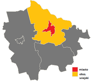
Gmina Sieraków Gmina in Greater Poland, Poland

Gmina Sieraków is an urban-rural gmina in Międzychód County, Greater Poland Voivodeship, in west-central Poland. Its seat is the town of Sieraków, which lies approximately 16 kilometres (10 mi) east of Międzychód and 62 km (39 mi) north-west of the regional capital Poznań.

Gmina Szamotuły is an urban-rural gmina in Szamotuły County, Greater Poland Voivodeship, in west-central Poland. Its seat is the town of Szamotuły, which lies approximately 32 kilometres (20 mi) north-west of the regional capital Poznań.

Gmina Kaźmierz is a rural gmina in Szamotuły County, Greater Poland Voivodeship, in west-central Poland. Its seat is the village of Kaźmierz, which lies approximately 10 kilometres (6 mi) south of Szamotuły and 26 km (16 mi) north-west of the regional capital Poznań.

Gmina Obrzycko is a rural gmina in Szamotuły County, Greater Poland Voivodeship, in west-central Poland. Its seat is the town of Obrzycko, although the town is not part of the territory of the gmina.

Gmina Ostroróg is an urban-rural gmina in Szamotuły County, Greater Poland Voivodeship, in west-central Poland. Its seat is the town of Ostroróg, which lies approximately 9 kilometres (6 mi) north-west of Szamotuły and 40 km (25 mi) north-west of the regional capital Poznań.

Gmina Pniewy is an urban-rural gmina in Szamotuły County, Greater Poland Voivodeship, in west-central Poland. Its seat is the town of Pniewy, which lies approximately 24 kilometres (15 mi) south-west of Szamotuły and 46 km (29 mi) west of the regional capital Poznań.

Chojno, Szamotuły County Village in Greater Poland, Poland

Chojno is a village in the administrative district of Gmina Wronki, within Szamotuły County, Greater Poland Voivodeship, in west-central Poland. It lies approximately 12 kilometres (7 mi) west of Wronki, 28 km (17 mi) north-west of Szamotuły, and 59 km (37 mi) north-west of the regional capital Poznań.

Chojno-Błota Małe Village in Greater Poland, Poland

Chojno-Błota Małe is a village in the administrative district of Gmina Wronki, within Szamotuły County, Greater Poland Voivodeship, in west-central Poland. It lies approximately 12 kilometres (7 mi) west of Wronki, 29 km (18 mi) north-west of Szamotuły, and 60 km (37 mi) north-west of the regional capital Poznań.

Chojno-Błota Wielkie Village in Greater Poland, Poland

Chojno-Błota Wielkie is a village in the administrative district of Gmina Wronki, within Szamotuły County, Greater Poland Voivodeship, in west-central Poland. It lies approximately 11 kilometres (7 mi) west of Wronki, 28 km (17 mi) north-west of Szamotuły, and 59 km (37 mi) north-west of the regional capital Poznań.

Chojno-Młyn Village in Greater Poland, Poland

Chojno-Młyn is a village in the administrative district of Gmina Wronki, within Szamotuły County, Greater Poland Voivodeship, in west-central Poland. It lies approximately 15 kilometres (9 mi) west of Wronki, 30 km (19 mi) west of Szamotuły, and 60 km (37 mi) north-west of the regional capital Poznań.

Huby-Oporowo Village in Greater Poland, Poland

Huby-Oporowo is a village in the administrative district of Gmina Wronki, within Szamotuły County, Greater Poland Voivodeship, in west-central Poland. It lies approximately 4 kilometres (2 mi) south-east of Wronki, 15 km (9 mi) north-west of Szamotuły, and 47 km (29 mi) north-west of the regional capital Poznań.

Lubowo, Greater Poland Voivodeship Village in Greater Poland, Poland

Lubowo is a village in the administrative district of Gmina Wronki, within Szamotuły County, Greater Poland Voivodeship, in west-central Poland. It lies approximately 9 kilometres (6 mi) west of Wronki, 26 km (16 mi) north-west of Szamotuły, and 57 km (35 mi) north-west of the regional capital Poznań.

Oporowo-Huby is a village in the administrative district of Gmina Wronki, within Szamotuły County, Greater Poland Voivodeship, in west-central Poland.

References