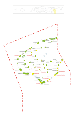
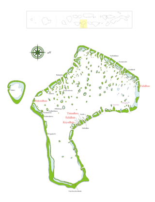
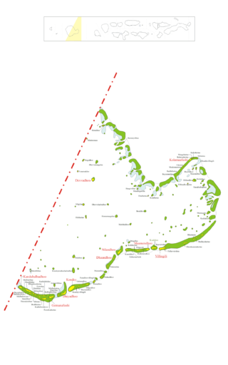
Gnaviyani Atoll

Last updated
Gnaviyani Atoll
Gnaviyani Atoll.png
Gnaviyani in Maldives.svg
Country Maldives
Corresponding geographic atoll(s)Fuvahmulah
Location0° 15' S and 0° 20' S
Capital Fuvahmulah
Government
  City MayorIsmail Rafeeq (MDP)
Population
 (2022) [1]
  Total9,166
Letter code
R
Dhivehi letter code
Gn (ޏ)
 • Number of islands1
 • Inhabited islands Fuvahmulah
Resort islands(*), airports(¤) and industrial islands are also considered uninhabited.

Gnaviyani Atoll (Pronounced: Nyaviyani) is one of the administrative divisions of the Maldives corresponding to the natural atoll, Fuvahmulah. Surfacewise this is the smallest administrative unit in the Maldives, situated on the Equatorial Channel (Addu - Mulah Kandu) between Huvadhu Atoll and Addu Atoll.

Contents

Geography

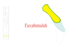
The atoll of Fuvahmulah corresponding to this administrative division is the 25th natural atoll of the Maldives. Some people due to lack of knowledge or as part of a prevailing misconception erroneously mention that Fuvahmulah is not an atoll. An island of coral that encircles a lagoon partially or completely is what we call an atoll. In the distant past Fuvahmulah was a small coral atoll whose southern end was open at a spot called Diyarehifaando and the inside of the island was a saltwater lagoon forming a natural harbour. There is a spot in the southern end known as a Kudhuheraivali (the forest of the small islet), which indicates that there was a separate little island in that area in ancient times. Later the channel connecting the lagoon with the ocean was closed by massive coral boulders. Thus the inside of the island is lower than its edges. In time the inner lagoon lost its saltiness and all that remains today are two small lakes(Kulhi), wetlands and marshy taro fields. Therefore, Fuvahmulah is a small Atoll that closed and filled in with silt, like Nukutavake in the Central Pacific.

Municipal Divisions

Fuvahmulah was traditionally divided into nine wards. From North to South these wards were: (1) Dhadimago, (2) Diguvāndo (both stretching from East to West shore), (3) Hōdhado, (5) Dhashokubaa (both segmental) separated by, (4) Mādhado (A diagonal strip of parallel width); whilst the other four divisions, which occupied the Southern part of the island consisted of two Eastern and Western strips, bisected into four wards, (6) Mālegan and (8) Dūndigan lying to East, (7) Miskimmago and (9) Funādo to West.

The largest division among all is Dhadimago. With time, some changes saw its way into existence. Nowadays, the number of wards has been reduced to eight, since the village of Dhashokubaa was merged with Miskimmago. Moreover, extension of some wards with time, brought its way into certain changes in area such as that of Hōdhado. The northerly extension of the ward by time led to the land from Eastern strip of Diguvāndo and some parts of that of Dhadimago being claimed to the village. It was mainly the land consisting of agricultural fields and plantations to vegetation owned by the villagers of Dhadimago and Diguvāndo.

Administratively these divisions act as the replacement for islands in other atolls. For each ward a chief ('Katheeb') was appointed as in charge of the day-to-day affairs of the respective ward and held accountable for an Island chief. With the introduction of local government policy in the Maldives, an Island Council is to be elected for each ward of the island according to the Decentralisation act 2010. Also, an Atoll Council is to be elected for the atoll as a whole.

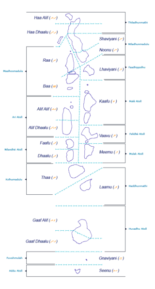
NOTE:Haa Alifu, Haa Dhaalu, Shaviyani, Noonu, Raa, Baa, Kaafu, etc.. (including Gnaviyani) are code letters assigned to the present administrative divisions of the Maldives. They are not the proper names of the natural atolls that make up these divisions. Some atolls are divided into two administrative divisions or contain half of an atoll (In case of Thiladhunmathi to Haa Alif, Haa Dhaal, Shaviyani and Noonu Atolls, Huvadhu Atoll to Gaafu Alifu and Gaafu Dhaalu Atolls and In case of half of Ari Atoll to Alifu Dhaalu Atoll), while other divisions are made up of two or more natural atolls (In case of Raa, Baa, Kaafu, Alifu Alifu and Vaavu Atolls). Some administrative divisions correspond to the same natural atoll too (In case of Lhaviyani, Meemu, Faafu, Dhaalu, Thaa, Laamu, Gnaviyani and Seenu Atolls). The order followed by the code letters are from North to South, beginning with the first letters of the Thaana alphabet used in Dhivehi. These code letters may not be accurate from the geographical and cultural point of view. However, they have become popular among tourists and foreigners in the Maldives who find them easier to pronounce than the true atoll names in Dhivehi, (save a few exceptions, like Ari Atoll).

Aware of the extent of this problem, Maldivian expert Mr. Ibrahim Luthfee wrote a book on Maldivian geography before he died. With this book, which is unfortunately available only in Dhivehi, the late Mr. Luthfee tried to clear a number of misconceptions that carelessly researched tourist publications have generalized even among Maldivians. Much of this article has been translated and adapted from his posthumous work.

Related Research Articles

Thaana, Tãnaa, Taana or Tāna is the present writing system of the Maldivian language spoken in the Maldives. Thaana has characteristics of both an abugida and a true alphabet, with consonants derived from indigenous and Arabic numerals, and vowels derived from the vowel diacritics of the Arabic abjad. Maldivian orthography in Thaana is largely phonemic.

<span class="mw-page-title-main">Huvadhu Atoll</span> Atoll in the Indian Ocean

Huvadhu, Suvadive, Suvaidu or Suvadiva is the atoll with the most islands in the world. The atoll is located in the Indian Ocean. It is south of the Suvadiva Channel in the Republic of Maldives with a total area of 3,152 km2, of which 38.5 km2 is dry land. The atoll contains 255 islands.

<span class="mw-page-title-main">Atolls of the Maldives</span> Physical geographic entity

The Maldives are formed by 20 natural atolls, along with a few islands and isolated reefs today which form a pattern stretching from 7 degrees 10′ North to 0 degrees 45′ South. The largest of these atolls is Boduthiladhunmathi, while the atoll containing the most islands is Huvadhu.

<span class="mw-page-title-main">Faafu Atoll</span> Atoll of the Maldives

Faafu Atoll is an administrative division of the Maldives. It corresponds to the natural atoll of the same name.

<span class="mw-page-title-main">Northern Thiladhunmathi Atoll</span> Atoll of the Maldives

Haa Alif Atoll - officially referred as Thiladhunmathi Uthuruburi is the northernmost administrative division of the Maldives.

<span class="mw-page-title-main">Haa Dhaalu Atoll</span> Atoll of the Maldives

Haa Dhaalu Atoll is the code name based on the letters of the Maldivian alphabet commonly used to refer to the administrative division officially known as South Thiladhunmathi Atoll in the Maldives.

<span class="mw-page-title-main">Noonu Atoll</span> Atoll of the Maldives

Noonu Atoll is an administrative division of the Maldives corresponding to the southern section of Miladhunmadulu Atoll. The capital is Manadhoo. Total population of Noonu Atoll is around 10,000 people.

<span class="mw-page-title-main">Raa Atoll</span> Atoll of the Maldives

Raa Atoll is an administrative division from the Maldives. The capital is Ungoofaaru. It includes Northern Maalhosmadulu Atoll proper and the island of Alifushi. Raa Atoll has the highest amount of populated islands in the Maldives.

<span class="mw-page-title-main">Lhaviyani Atoll</span> Atoll of the Maldives

Lhaviyani Atoll is an administrative division of the Maldives. Its abbreviation is Lh.

<span class="mw-page-title-main">Vaavu Atoll</span> Atoll of the Maldives

Vaavu Atoll is an administrative division of the Maldives, comprising the natural atolls of Felidhu Atoll and the Vattaru Reef.

<span class="mw-page-title-main">Meemu Atoll</span> Atoll of the Maldives

Mulaku Atoll or Meemu Atoll is an administrative division of the Maldives. It corresponds to the natural atoll of the same name, also known as Mulak Atoll or 'Mulakatolhu'.

<span class="mw-page-title-main">Gaafu Alifu Atoll</span> Atoll of the Maldives

Gaafu Alifu is an administrative division of the Maldives created on February 8, 1962, when Huvadhu Atoll was divided into two districts. Gaafu Alifu corresponds to the northeastern section of this large natural atoll north of the line extending between the channels of Footukandu and Vaarulu Kandu. The capital of this district is Vilingili.

<span class="mw-page-title-main">Gaafu Dhaalu Atoll</span> Administrative district of the Maldives

Gaafu Dhaalu is an administrative district of the Maldives formed by the southwestern section of Huvadhu Atoll. It was created on February 8, 1962, when Huvadhu Atoll was divided into two districts. Gaafu Dhaalu corresponds to the Southwestern section of this large natural atoll, south of the line extending between the channels of Footukandu and Vaarulu Kandu. The capital of this region is Thinadhoo (Thenadhoo). There are 153 islands in this district, 10 of which are inhabited. This district is located about 340 kilometers south of the capital Malé.

<span class="mw-page-title-main">Administrative divisions of the Maldives</span>

The Administrative Divisions of the Maldives refers to the various units of government that provide local government services in the Maldives. According to the Decentralization Act 2010, the administrative divisions of the Maldives would consist of atolls, islands, and cities; each administered by their own local council, under the basic terms of home rule. Geographically, the Maldives are formed by a number of natural atolls plus a few islands and isolated reefs which form a pattern from North to South. Administratively, there are currently 189 islands, 18 atolls and 4 cities in the Maldives.

<span class="mw-page-title-main">Outline of Maldives</span> Overview of and topical guide to Maldives

The following outline is provided as an overview of and topical guide to the Maldives:

<span class="mw-page-title-main">Maldivian language</span> Indo-Aryan national language of Maldives

Dhivehi or Divehi, is an Indo-Aryan language spoken in the South Asian island country of Maldives and on Minicoy Island, Lakshadweep, a union territory of India.

There are broad channels between the Atolls of the Maldives known locally as 'kandu'. The deepness and broadness of the channels vary from channel to channel.

Mulah Kandu, Dv. for "Mulah Channel", is the channel between Fuvahmulah and Addu Atoll.

References

  1. "2022 Census Provisional Results". census.gov.mv. Retrieved 2023-04-01.

0°18′S73°26′E / 0.300°S 73.433°E / -0.300; 73.433