Addu Kandu

Last updated
Maledives location map.svg
Cercle rouge 100%25.svg
Equatorial Channel

Addu Kandu, Dv. for "Addu Channel", is the traditional name of the broad channel between Huvadhu Atoll and Addu Atoll in the south of Maldives.

Huvadhu Atoll

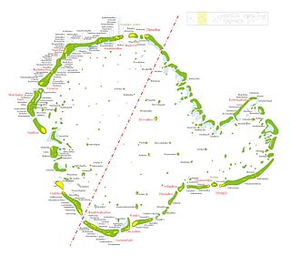
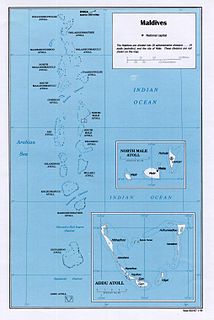
Huvadhu is a large atoll located south of the Suvadiva Channel the Republic of Maldives. With a total area of 3152 km², of which 38.5 km² is dry land, it is the second largest geographical atoll in the country, after Boduthiladhunmathi

Addu Atoll atoll of the Maldives

Addu Atoll, also known as Seenu Atoll, is the southernmost atoll of the Maldives. Addu Atoll, together with Fuvahmulah, located 40 km north of Addu Atoll, extend the Maldives into the Southern Hemisphere. Addu Atoll is located 540 km south of Malé, the country's capital. Administratively, Addu Atoll is the location of Addu City, one of the two cities of the Maldives. Addu City consists of the inhabited areas of Addu Atoll, namely the natural islands of Hulhudhoo, Meedhoo, Maradhoo, Feydhoo, and Hithadhoo.. In addition to the areas that are included as a part of Addu City, Addu Atoll has a number of other inhabited and uninhabited islands, including the island of Gan, where Gan International Airport is located.

Maldives South Asian country in the Indian Ocean

The Maldives, officially the Republic of Maldives, is an Asian country, located in the Indian Ocean, situated in the Arabian Sea. It lies southwest of Sri Lanka and India, about 1,000 kilometres (620 mi) from the Asian continent. The chain of 26 atolls stretches from Ihavandhippolhu Atoll in the north to the Addu City in the south. Comprising a territory spanning roughly 298 square kilometres (115 sq mi), the Maldives is one of the world's most geographically dispersed sovereign states as well as the smallest Asian country by land area and population, with around 427,756 inhabitants. Malé is the capital and a populated city, traditionally called the "King's Island" for its central location.

In the British Admiralty charts it is called Equatorial Channel because the Equator passes through its midst.

Equator Intersection of a spheres surface with the plane perpendicular to the spheres axis of rotation and midway between the poles

An equator of a rotating spheroid is its zeroth circle of latitude (parallel). It is the imaginary line on the spheroid's surface, equidistant from its poles, dividing it into northern and southern hemispheres. In other words, it is the intersection of the spheroid's surface with the plane perpendicular to its axis of rotation and midway between its geographical poles.

Within Addu Kandu the Equatorial Channel divides to form another important channel named Mulah Kandu. Geographically a part of Addu Kandu, it is located north-east of Addu Atoll, between the eastern end of this atoll and Fuvahmulah at a lat of 0° 17' S, southwards from the centre of the main channel.

Mulah Kandu, Dv. for "Mulah Channel", is the channel between Fuvahmulah and Addu Atoll.

Fuvahmulah Inhabited island in Maldives

Fuvahmulah City is an island (atoll) in the Maldives. It is under Maldives administrative divisions of Gnaviyani Atoll or Nyaviyani Atoll. The inhabitants speak a distinctive form of the Dhivehi language, known as "dhivehi bas".

This channel appeared in old French maps with the name Courant de Addoue.

See also

Related Research Articles

Geography of the Maldives

Maldives is a country of South Asia, situated in the Indian Ocean, south-southwest of India. It consists of approximately 1,190 coral islands grouped in a double chain of 26 atolls, spread over roughly 90,000 square kilometers, making this one of the most disparate countries in the world. Composed of live coral reefs and sand bars, the atolls are situated atop a submarine ridge, 960 km (600 mi) long that rises abruptly from the depths of the Indian Ocean and runs from north to south. Only near the southern end of this natural coral barricade do two open passages permit safe ship navigation from one side of the Indian Ocean to the other through the territorial waters of Maldives. For administrative purposes the Maldives government organized these atolls into nineteen administrative divisions.

Atolls of the Maldives physical geographic entity

The Maldives are formed by a number of natural atolls plus atolls in the form of a few islands and isolated reefs today which form a pattern stretching from 7 degrees 10′ North to 0 degrees 45′ South.

Addu City is a city in Maldives that consists of the inhabited islands of the southernmost atoll of the archipelago. Addu City is the second-largest urban area in Maldives, in terms of population, and is one of the two urban areas to get the status of "city" other than the capital city, Malé and Fuvamulah. Addu City has 6 districts. They are Hithadhoo, Maradhoo-Feydhoo, Maradhoo, Feydhoo, Hulhudhoo and Meedhoo. These divisions are naturally islands, but are well connected. Addu Atoll itself has islands in addition to the above, that are uninhabited. For information on these islands, see Addu Atoll.

Northern Thiladhunmathi Atoll Place in Maldives

Haa Alif Atoll - officially referred as Thiladhunmathi Uthuruburi is the northernmost administrative division of the Maldives.

Noonu Atoll atoll of the Maldives

Noonu Atoll is an administrative division of the Maldives corresponding to the southern section of Miladhunmadulu Atoll. The capital is Manadhoo. Total population of Noonu Atoll is around 10.000 people.

Gaafu Alif Atoll atoll of the Maldives

Gaafu Alifu is an administrative division of the Maldives created on February 8, 1962 when Huvadhu Atoll was divided into two districts. Gaafu Alifu corresponds to the northeastern section of this large natural atoll north of the line extending between the channels of Footukandu and Vaarulu Kandu. The capital of this district is Vilingili.

Gaafu Dhaalu Atoll atoll of the Maldives

Gaafu Dhaalu is an administrative district of the Maldives formed by the southwestern section of Huvadhu Atoll. It was created on February 8, 1962 when Huvadhu Atoll was divided into two districts. Gaafu Dhaalu corresponds to the Southwestern section of this large natural atoll, south of the line extending between the channels of Footukandu and Vaarulu Kandu. The capital of this region is Thinadhoo. There are 153 islands in this district, 10 of which are inhabited. This district is located about 340 kilometres south of the capital Malé.

Gnaviyani Atoll atoll of the Maldives

Gnaviyani Atoll is one of the administrative divisions of the Maldives corresponding to the natural atoll, Fuvahmulah. Surfacewise this is the smallest administrative unit in the Maldives, situated in the Equatorial Channel between Huvadhu Atoll and Addu Atoll.

Southern Miladhunmadulu Atoll Place in Maldives

Southern Miladhunmadulu Atoll or Noonu is a local administrative division of the Maldives corresponding to the southern section of Miladhunmadulu Atoll. The capital is Manadhoo.

Southern Maalhosmadulu Atoll Place in Maldives

Southern Maalhosmadulu Atoll is an administrative division of the Maldives. It consists of two separate natural atolls, namely the southern part of Maalhosmadulhu Atoll and the smaller natural atoll known as Goifulhafehendhu Atoll. Situated on the west of the Maldives atoll chain, it consists of 75 islands of which 13 are inhabited with a population of over 11,000 people. The remaining 57 islands are uninhabited, in addition to five islands being developed as resorts. Thulhaadhoo Island is traditionally well known for its lacquerwork handicrafts.

Maliku Kandu and Māmalē Kandu [dakshlanguage|Divehi]] are the traditional names of the broad Minicoy Channel between Minicoy and Ihavandippolhu in the north of the Maldives. The latter name is given after the Malabar merchant Maamaley Marakkaaru who controlled most of the sea trade along this route before the arrival of the Portuguese in the Indian Ocean. The maritime boundary between the Maldives and India runs through the channel.

Huvadhu Kandu

Suvadiva Channel is the broad channel that separates the northern and central Maldives from the southern atolls.

Kardiva Channel is a broad channel running from southwest to northeast and cutting across the Maldive atoll chain. This channel divides the Northern from the Central atolls of the Maldives.

Diving in the Maldives

The Maldives has become one of the world's best scuba diving destinations because of the white sand beaches, coral reefs, clear warm waters, numerous scuba diving sites and rich marine life.

There are broad channels between the Atolls of the Maldives known locally as 'kandu'. The deepness and broadness of the channels vary from channel to channel.

Equatorial Convention Centre (ECC) is a convention centre which is located in Hithadhoo, Addu City of Maldives. It was specially build for the seventeenth SAARC summit which was held in November 2011 in Addu City and nearby Fuvahmulah island. ECC was formally opened by the President of the Maldives H.E Mohamed Nasheed on November 10, 2011.

Haa Alif Atoll atoll of the Maldives

Haa Alif Atoll is the code name based on the letters of the Maldivian alphabet commonly used to refer to the administrative division officially known as North Thiladhunmathi Atoll in the Maldives.

References

International Standard Book Number Unique numeric book identifier

The International Standard Book Number (ISBN) is a numeric commercial book identifier which is intended to be unique. Publishers purchase ISBNs from an affiliate of the International ISBN Agency.

Coordinates: 0°10′00″N73°00′00″E / 0.16667°N 73.00000°E / 0.16667; 73.00000

Geographic coordinate system Coordinate system

A geographic coordinate system is a coordinate system that enables every location on Earth to be specified by a set of numbers, letters or symbols. The coordinates are often chosen such that one of the numbers represents a vertical position and two or three of the numbers represent a horizontal position; alternatively, a geographic position may be expressed in a combined three-dimensional Cartesian vector. A common choice of coordinates is latitude, longitude and elevation. To specify a location on a plane requires a map projection.