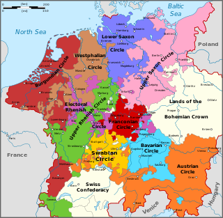
During the Early Modern period the Holy Roman Empire was divided into Imperial Circles, administrative groupings whose primary purposes were the organization of common defensive structure and the collection of imperial taxes. They were also used as a means of organization within the Imperial Diet and the Imperial Chamber Court. Each circle had a Circle Diet, although not every member of the Circle Diet would hold membership of the Imperial Diet as well.

Königstein Fortress, the "Saxon Bastille", is a hilltop fortress near Dresden, in Saxon Switzerland, Germany, above the town of Königstein on the left bank of the River Elbe. It is one of the largest hilltop fortifications in Europe and sits atop the table hill of the same name.

Saxon Switzerland is a hilly climbing area and national park around the Elbe valley south-east of Dresden in Saxony, Germany. Together with the Bohemian Switzerland in the Czech Republic it forms the Elbe Sandstone Mountains.

The Elbe Sandstone Mountains, also called the Elbe Sandstone Highlands is a mountain range straddling the border between the state of Saxony in southeastern Germany and the North Bohemian region of the Czech Republic, with about three-quarters of the area lying on the German side. In both countries, core parts of the mountain range have been declared a national park. The name derives from the sandstone which was carved by erosion. The river Elbe breaks through the mountain range in a steep and narrow valley.

Himmelpforten is a municipality west of Hamburg (Germany) in the district of Stade in Lower Saxony. It is located on the Horsterbeck creek. Himmelpforten is also part and the seat of the Samtgemeinde Oldendorf-Himmelpforten.

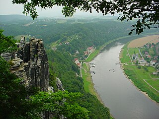
The Bastei is a rock formation rising 194 metres above the Elbe River in the Elbe Sandstone Mountains of Germany. Reaching a height of 305 metres above sea level, the jagged rocks of the Bastei were formed by water erosion over one million years ago. They are situated near Rathen, not far from Pirna southeast of the city of Dresden, and are the major landmark of the Saxon Switzerland National Park. They are also part of a climbing and hiking area that extends over the borders into the Bohemian Switzerland.
Saxon Switzerland National Park, is a National Park in the German Free State of Saxony, near the Saxon capital Dresden. It covers two areas of 93.5 km² (36.1 mi²) in the heart of the German part of the Elbe Sandstone Mountains, which is often called (the) Saxon Switzerland.

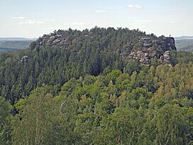
The Zirkelstein is the smallest table hill of Saxon Switzerland, in Germany. It is a wooded, cone-shaped hill with a striking 40-metre-high (130 ft) summit block of sandstone rock.

Hohnstein Castle is a medieval castle in the village of the same name, Hohnstein in Saxon Switzerland in the Free State of Sachsen in East Germany.

The Lokomotive is a striking climbing rock north of Kurort Rathen in Saxon Switzerland in Germany. The rock, which resembles a steam locomotive in appearance, is also known as Große Ruine, is about 30 metres high and is divided into two parts: known as Lokomotive-Dom and Lokomotive-Esse. The ridge between the two is called the Kesselgrat, the rock teeth next to the Esse as Pfeife ("Whistle"). For a short time there was a weather vane on the dome in the shape of a wheel. The Lokomotive rises on the massif of the Honigsteine.

The Pfaffenstein, formerly called the Jungfernstein, is a table hill, 434.6 m (1,426 ft) above sea level, in the Elbe Sandstone Mountains in Saxony. It lies west of the River Elbe near Königstein and is also referred to as "Saxon Switzerland in miniature" on account of its diverse structure.
The Quirl is a low table hill, 349 metres high, in Saxon Switzerland, west of the River Elbe.

Saxon Switzerland is the largest and one of the best-known climbing regions in Germany, located in the Free State of Saxony. The region is largely coterminous with the natural region of the same name, Saxon Switzerland, but extends well beyond the territory of the National Park within it. It includes the western part of the Elbe Sandstone Mountains and is the oldest non-Alpine climbing region in Germany. Its history of climbing dates back to the first ascent in modern times of the Falkenstein by Bad Schandau gymnasts in 1864. Currently, there are over 1,100 summits with more than 17,000 climbing routes in the Saxon Switzerland area.
The Bergtest near Wehlen is a traditional sporting event that has taken place annually since 1980, usually on the last Saturday in March, in the East German hills of Saxon Switzerland.

The Teufelsturm is a prominent rock tower and climbing rock formed of Elbe Sandstone, about forty metres high in Saxon Switzerland in East Germany. It is located east of the River Elbe on the upper edge of the valley between Schmilka and Bad Schandau in the Schrammsteinen. The Teufelsturm is also referred to as the "Symbol of Saxon Climbing".

Altrathen Castle is located on a rock outcrop near Rathen in Saxon Switzerland in the German Free State of Saxony.
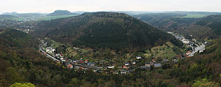
The Biela Valley Trolleybus was a trolleybus service in the German state of Saxony. The facility opened on 10 July 1901 and had closed again by September 1904. It was one of the first trolleybus operations in the world. The 4.4-kilometre route was also known at the time as the Gleislose Bahn or "trackless railway" – its full name being Gleislose Bielathal-Motorbahn mit elektrischer Oberleitung. It was operated by the firm of Bielathal-Motorbahn Königstein and served the lower valley of the Biela in Saxon Switzerland. The route linked Königstein on the Elbe with the then-independent village of Hütten. The terminus was at Kurbad Königsbrunn.

Neurathen Castle, which was first mentioned by this name in 1755, is located near the famous Bastei rocks near Rathen in Saxon Switzerland in the German Free State of Saxony. This was once the largest rock castle in the region, but today only the rooms carved out of the rock, passages, the cistern and rebates for the timber of the former wooden superstructure have survived. In the years 1982–1984 parts of the extensive castle were used to build the open-air museum.

Oppidum Uetliberg was a La Tène era oppidum located near the top of the hill Uetliberg in what is now the Swiss canton of Zurich.

The Schwedenlöcher is a gorge-like side valley of the Amselgrund near Rathen in Saxon Switzerland.