Goidhoo (Baa Atoll)

Last updated
Goidhoo
Baa Goidhoo.jpg
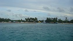
Goidhoo Harbor, When entering Goidhoo
Maledives relief location map.jpg
Red pog.svg
Goidhoo
Location in Maldives
Coordinates: 04°52′25″N72°59′59″E / 4.87361°N 72.99972°E / 4.87361; 72.99972 Coordinates: 04°52′25″N72°59′59″E / 4.87361°N 72.99972°E / 4.87361; 72.99972
Country Maldives
Administrative atoll Baa Atoll
Distance to Malé95.69 km (59.46 mi)
Area
  Total1.1354 km2 (0.4384 sq mi)
Dimensions
  Length2.130 km (1.324 mi)
  Width1.580 km (0.982 mi)
Population
(2014) [1]
  Total543 (including foreigners)
Time zone UTC+05:00 (MST)

Goidhoo (Dhivehi: ގޮއިދޫ) is one of the inhabited islands of Southern Maalhosmadulhu Atoll, code letter "Baa".

Contents

History

In the 19th century, a female African slave who had been bought by the king on his Hajj trip to Mecca was formally released from slavery and was settled in Goidhoo island. A house and a well were built for her. This African woman was called Salaamaa. She had been working for years at the palace in Malé before the ailing king released her in order to gain merit in the afterlife.[ citation needed ]

Arab slave trade slave trade in the Arab Islamic world between the 7th and 20th centuries

The Arab slave trade was the intersection of slavery and trade in the Arab world, mainly in Western Asia, North Africa, East Africa and Europe. This barter occurred chiefly between the medieval era and the early 20th century. The trade was conducted through slave markets in these areas, with the slaves captured mostly from Africa's interior and Southern Europe.

The freeing of slaves before the death of the owner was traditionally a common practice among the very high nobility in the Maldives. Now there are some families from Goidhoo that can trace their descendency to this African ancestor.[ citation needed ]

Geography

The island is 95.69 km (59 mi; 52 nmi) northwest of the country's capital, Malé. [2]

Malé City in North Malé Atoll, Maldives

Malé is the capital and most populous city in the Republic of Maldives. With a population of 133,412 and an area of 9.27 square kilometres (3.58 sq mi), it is also one of the most densely populated cities in the world. The city is geographically located at the southern edge of North Malé Atoll. Administratively, the city consists of a central island, an airport island, and two other islands governed by the Malé City Council.

Horsburgh Atoll

Goidhu Island lies in a small separate atoll along with Fulhadu and Fehendhu. Goidhoo Atoll (also Goidu or Goifulhafehendhu), Horsburgh Atoll in the Admiralty Chart, is separated from South Maalhosmadulhu by a six-mile-broad (9.7 km) channel. This atoll is oval in shape and small, its greatest length being 10 miles (16 km). The inner lagoon has a depth of 17 to 20 fathoms; it has a sandy bottom mixed with mud and clay. Unlike the lagoons of most small atolls of the Maldives, this lagoon is free from coral heads in its centre.

In the Admiralty charts, this atoll is named after James Horsburgh, hydrographer to the East India Company and author of the long-titled Directions for Sailing to and from the East Indies, China, New Holland, Cape of Good Hope, and the interjacent Ports, compiled chiefly from original Journals and Observations made during 21 years' experience in navigating those Seas. Horsburgh's Directory was the standard work for oriental navigation in the first half of the 19th century, until Robert Moresby's survey of the Maldives when for the first time in history accurate maps of the atolls were published.

Admiralty chart

Admiralty charts are nautical charts issued by the United Kingdom Hydrographic Office (UKHO) and subject to Crown Copyright. Over 3,500 Standard Nautical Charts (SNCs) and 14,000 Electronic Navigational Charts (ENCs) are available with the Admiralty portfolio offering the widest official coverage of international shipping routes and ports, in varying detail.

James Horsburgh British hydrographer

James Horsburgh was a Scottish hydrographer. He worked for the British East India Company, (EIC) and mapped many seaways around Singapore in the late 18th century and early 19th century.

Robert Moresby Bombay Marine/Indian Navy officer

Robert Moresby was a captain of the East India Company's Bombay Marine/Indian Navy who distinguished himself as a hydrographer, maritime surveyor and draughtsman.

Demography

Historical population
YearPop.±%
2006 503    
2014 507+0.8%
2006-2014: Census populations
Source: [3]

See also

Related Research Articles

Atolls of the Maldives physical geographic entity

The Maldives are formed by a number of natural atolls plus atolls in the form of a few islands and isolated reefs today which form a pattern stretching from 7 degrees 10′ North to 0 degrees 45′ South.

Dhanbidhoo or Dambidū is one of the inhabited islands of Haddummati Atoll, administrative code Laamu.

Isdhoo (Laamu Atoll) Inhabited island in Maldives

Isdhoo or Isdū is one of the inhabited islands of Haddhunmathi Atoll, administrative code Laamu part of Maldives in the Indian Ocean.

Vandhoo is one of the inhabited islands of Thaa Atoll.

Fulidhoo (Dhivehi:ފުލިދޫ) is the most northern of the inhabited islands of Vaavu Atoll in the Maldives. It is famous for Maldivian cultural events like Langiri, a traditional dance with drums and Thaara.

Feridhoo is one of the inhabited islands of Ari Atoll, located on its eastern fringe. It belongs to the Alif Alif Atoll administrative division.

Maalhos is one of the inhabited islands of Ari Atoll, belonging to the Alif Alif Atoll administrative division.

Gaafaru is one of the inhabited islands of Kaafu Atoll, the only island of the natural atoll known as Gaafaru.

Kaashidhoo (Kaafu Atoll) Inhabited island in Maldives

Kaashidhoo is one of the inhabited islands of Kaafu Atoll.

Fehendhoo is one of the inhabited islands of Southern Maalhosmadulhu Atoll, code letter "Baa" in the Dhivehi alphabet and code letter "F-15" in English.

Fulhadhoo is one of the inhabited islands of Southern Maalhosmadulhu Atoll, code letter "Baa". It is 31.5 hectares in area.

Kudarikilu is one of the inhabited islands of Southern Maalhosmadulhu Atoll.

Maalhos known as one of the inhabited islands of Southern Maalhosmadulhu Atoll, code letter Baa Atoll.

Alifushi Inhabited island in Maldives

Alifushi is one of the inhabited islands of Raa Atoll.

Goidhoo is one of the inhabited islands of the Shaviyani Atoll administrative division and geographically part of the Miladhummadulhu Atoll in the Maldives.

Kanditheemu is one of the inhabited islands of Shaviyani Atoll administrative and geographically part of the Miladhummadulhu Atoll in the Maldives.

Makunudhoo is one of the inhabited islands of Haa Dhaalu Atoll administrative division and geographically part of Māmakunudhoo Atoll in the north of the Maldives. It is the westernmost inhabited island in the Maldives.

Nolhivaram, Nolhivaran or Nolhivaramu is one of the inhabited islands of Haa Dhaalu Atoll administrative division and geographically part of Thiladhummathi Atoll in the north of the Maldives.

Rasdhoo is an inhabited island of the Maldives. It is also the capital of the Alif Alif Atoll administrative division.

Southern Maalhosmadulu Atoll Place in Maldives

Southern Maalhosmadulu Atoll is an administrative division of the Maldives. It consists of two separate natural atolls, namely the southern part of Maalhosmadulhu Atoll and the smaller natural atoll known as Goifulhafehendhu Atoll. Situated on the west of the Maldives atoll chain, it consists of 75 islands of which 13 are inhabited with a population of over 11,000 people. The remaining 57 islands are uninhabited, in addition to five islands being developed as resorts. Thulhaadhoo Island is traditionally well known for its lacquerwork handicrafts.
References

  1. "Table PP5: Resident Population by sex, nationality and locality (administrative islands), 2014" (PDF). Population and Households Census 2014. National Bureau of Statistics. p. 34. Retrieved 12 August 2018.
  2. "Coordinate Distance Calculator". Boulter.com. Retrieved 12 August 2018.
  3. "Table 3.3: Total Maldivian Population by Islands" (PDF). National Bureau of Statistics. Retrieved 12 August 2018.