Phungling Municipality is a municipality located in Taplejung District in the Province No. 1 of Nepal. The municipality was formed merging the then two Village Development Committees of Phungling and Dokhu in May 2014. At the time of the 2011 Nepal census it had a population of 19,085 people and 4,480 individual households.

Mugu District (Nepali: मुगु जिल्लाListen , a part of Karnali province, is one of the seventy-seven districts of Nepal. The district, with Gamgadhi as its district headquarters, covers an area of 3,535 km2 and had a population of 55,286. Mugu is known for being both the most remote district in Nepal, as well as the least developed.

The administrative divisions of Nepal are subnational administrative units of Nepal. The first level of country subdivision of Nepal are the provinces. Each province is further subdivided into districts, each district into municipalities and rural municipalities, and each of those municipalities into wards. Before 2015, instead of provinces, Nepal was divided into developmental regions and administrative zones.

Solududhkunda (earlier:Dudhkunda) is the only municipality of Solukhumbu District. Located in Province No. 1 of Nepal. The town of Salleri, which is located within the municipality is the headquarter of Solukhumbu District It was formed in 2014 by merging four VDCs: Salleri, Garma, Loding Tamakhani and Beni and was divided into 9 wards. Total area of the municipality had 254.3 square kilometres (98.2 sq mi) and population of municipality had 20,399 individuals living in 5,368 households.

A Village Development Committee (VDC) in Nepal was the lower administrative part of its Ministry of Federal Affairs and Local Development. Each district had several VDCs, similar to municipalities but with greater public-government interaction and administration. There were 3,157 village development committees in Nepal. Each VDC was further divided into several wards depending on the population of the district, the average being nine wards.

Jogimara was a village development committee in Dhading District in the Bagmati Zone of central Nepal. At the time of the 1991 Nepal census it had a population of 5080 and had 927 houses in it. On March 10, 2017, the Government of Nepal restructured local level bodies into 753 new local level structures. Mahadevsthan, Benighat, Dhusha and Jogimara VDCs were merged to form Benighat Rorang. हुग्दिखोला Majhimtar Jamireghat is the main market of Jogimara VDC. Here lies a calcium ore.
Maidi is a village in Dhading District in the Bagmati Zone of central Nepal. At the time of the 1991 Nepal census it had a population of 8496 and had 1627 houses in it.

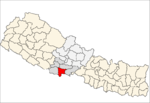
Holiya is a town in the Banke District in Lumbini Province of southwestern Nepal. At the time of the 1991 Nepal census, it had a population of 4,558, and there were 797 houses in the town.
Ballia is a village in Kailali District in the Seti Zone of western Nepal. At the time of the 1991 Nepal census it had a population of 17512 living in 3294 individual households.

Melung is a Rural municipality located within the Dolakha District of the Bagmati Province of Nepal. The municipality spans 86.54 square kilometres (33.41 sq mi) of area, with a total population of 20,210 according to a 2011 Nepal census.
Byans is a rural area of Byans Rural Municipality, previously it was a Village development committee (VDC) of Darchula District in Sudurpashchim Pradesh of western Nepal. At the time of the 1991 Nepal census it had a population of 723 people living in 150 individual households.
Tapoban is a village in Darchula District in the Mahakali Zone of western Nepal. At the time of the 1991 Nepal census it had a population of 1841 people living in 305 individual households.
Bhedihari is a village in the Parsa District of the Narayani Zone, southern Nepal. At the time of the 2011 Nepal census it had a population of 5,772 people living in 846 individual households. There were 2,977 males and 2,795 females at the time of census.

Markhu is a village in Makwanpur District in the Narayani Zone of southern Nepal. At the time of the 1991 Nepal census it had a population of 3137 people living in 581 individual households.
Hardauna is a village in the sub-metropolitan municipality of Maharajganj in the Kapilvastu District of the Lumbini Province. The village is in a region of outer terai in southern Nepal. It is on the Banganga, a river which arises on the southern slopes of the Sivalik Hills and flows across the terai, reaching into Uttar Pradesh state in India.
Kajarhawa is a village in Kapilvastu District in the Lumbini Province of southern Nepal. At the time of the 2001 Nepal census it had a population of 3438 people living in 571 individual households.
Gaunpalika is an administrative division in Nepal. The Ministry of Federal Affairs and Local Development (Nepal) dissolved the existing village development committees and announced the establishment of this new local body. It is a sub-unit of a district. There are currently 460 rural municipalities.

Kalinchowk is a Rural municipality located within the Dolakha District of the Bagmati Province of Nepal. The municipality spans 132.49 square kilometres (51.15 sq mi) of area, with a total population of 22,954 according to a 2011 Nepal census.

Bhojpur is a neighborhood in Bhojpur Municipality which is located in Bhojpur District in Province No. 1 of Nepal. The Bhojpur Village Panchayat was established in 1962 and was renamed as Bhojpur Village development committee in 1990.