
The Mary Rose is a carrack-type warship of the English Tudor navy of King Henry VIII. She served for 33 years in several wars against France, Scotland, and Brittany. After being substantially rebuilt in 1536, she saw her last action on 19 July 1545. She led the attack on the galleys of a French invasion fleet, but sank in the Solent, the strait north of the Isle of Wight.
Maritime archaeology is a discipline within archaeology as a whole that specifically studies human interaction with the sea, lakes and rivers through the study of associated physical remains, be they vessels, shore-side facilities, port-related structures, cargoes, human remains and submerged landscapes. A specialty within maritime archaeology is nautical archaeology, which studies ship construction and use.

Woodhenge is a Neolithic Class II henge and timber circle monument within the Stonehenge World Heritage Site in Wiltshire, England. It is 2 miles (3.2 km) north-east of Stonehenge, in Durrington parish, just north of the town of Amesbury.
HMS Colossus was a 74-gun third-rate ship of the line of the Royal Navy. She was launched at Gravesend on 4 April 1787 and lost on 10 December 1798. During her years of service she participated in the Battle of Groix, the Battle of Cape St Vincent, and the Battle of the Nile. While carrying wounded from the latter, she was wrecked at the Isles of Scilly. The wreck is a Protected Wreck managed by Historic England.

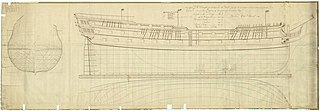
HMS Resolution was a 70-gun third-rate ship of the line of the Royal Navy, launched at Harwich Dockyard on 6 December 1667. She was one of only three third-rate vessels designed and built by the noted maritime architect Sir Anthony Deane.
St Anthony or Santo António was a Portuguese carrack that foundered in Gunwalloe Bay, Cornwall, in 1527 en route from Lisbon to Antwerp. She had a mixed cargo including copper and silver ingots. The wreck was recorded historically, because the salvage of the cargo was the subject of an international dispute that led to a Court of Star Chamber, but the location of the wreck was unknown until 1981. The wreck is designated under the Protection of Wrecks Act and is managed by Historic England.
Cattewater Wreck is a wooden three-masted, skeleton-built vessel, one of many ships that have wrecked in Cattewater, Plymouth Sound, England. This wreck is close to the entrance of Sutton Harbour, its name is still unknown but it is believed to be from the 16th Century. It is a Protected Wreck managed by Historic England.
HMS Northumberland was a 70-gun third-rate ship of the line of the Royal Navy, built by Francis Bayley of Bristol in 1677/79. She partook in the last great battle of the War of English Succession and the first battle of the War of Spanish Succession. She was lost in the Great Storm of November 1703.
Diamond was a three-masted square rigger, built in New York City in 1823. She was one of the first ships to operate a regular service for passenger and cargo between Britain and the United States. She sank en route to Liverpool from New York on 2 January 1825 in Cardigan Bay. The alleged wreck site was identified in 2000 and was designated under the Protection of Wrecks Act 1973 on 1 April 2002, the first such designation by the National Assembly for Wales. However, the identification has since been called into question.
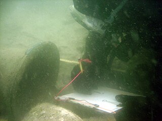
The Swash Channel Wreck is the remains of an early 17th-century armed merchantman possibly of Dutch origin wrecked outside of Poole Harbour. The vessel was approximately 40 m long and has been predicted to be around 600 tonnes. The ship was probably involved with the beginning of internationalization.
The Erme Estuary wreck is a shipwreck site containing the remains of potentially more than one wreck that was discovered in 1990 on Mary Reef in the Erme Estuary in Dorset. The site was designated under the Protection of Wrecks Act on 1 May 1991. The wreck is a Protected Wreck managed by Historic England.
The remains of an unknown armed cargo vessel dating to the sixteenth to seventeenth century were identified off Dunwich, Suffolk, England in 1993. The site was designated under the Protection of Wrecks Act on 12 July 1994. The wreck is a Protected Wreck managed by Historic England.
The Chesil Beach cannon consists of the remains of an unknown wreck were found on Chesil Beach, Dorset, England in 2010. The site was designated on 18 July 2017. The wreck is a Protected Wreck managed by Historic England.

The wreck of the Klein Hollandia was found in 2019, 14 km southeast of Beachy Head, East Sussex, England. The site was designated under the Protection of Wrecks Act on 5 July 2019. The wreck is a Protected Wreck managed by Historic England.
The remains of a late sixteenth or early seventeenth century carrack was discovered in Yarmouth Roads, Isle of Wight, England in 1984. The site was designated under the Protection of Wrecks Act on 9 April 1984. The wreck is a Protected Wreck managed by Historic England.
The wreck of a wooden sailing vessel was discovered in Thorness Bay, Isle of Wight, England in 2010. The site was designated under the Protection of Wrecks Act on 31 July 2013. The wreck is a Protected Wreck managed by Historic England.
The remains of a Middle Bronze Age vessel were identified in Langdon Bay, Kent, England in 1974. The site was designated under the Protection of Wrecks Act on 25 May 1978. The wreck is a Protected Wreck managed by Historic England.

The Rill Cove Wreck is an underwater wreck of a 16th-century Spanish cargo ship lying off the coast of Rill Cove, west of Kynance Cove, in Cornwall, England, UK.
The remains of an armed cargo vessel were discovered in 1983 in Studland Bay, off Dorset, England. The site was designated under the Protection of Wrecks Act on 22 October 1984. The wreck is a Protected Wreck managed by Historic England
The remains of an eighteenth- to nineteenth-century cargo vessel were discovered in the South Edinburgh Channel, Outer Thames Estuary, northwest of Margate, Kent, England, in 1976. The site was designated under the Protection of Wrecks Act on 29 April 1977. The wreck is a Protected Wreck managed by Historic England.