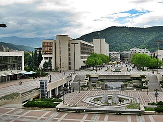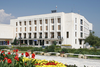
Blagoevgrad is а city in southwestern Bulgaria, the administrative centre of Blagoevgrad Municipality and of Blagoevgrad Province, with a population of 70,881 inhabitants. It lies on the banks of the Blagoevgradska Bistritsa River.

Gorna Oryahovitsa is a town in northern Bulgaria, situated in Veliko Tarnovo Province, 10 km (6 mi) from Veliko Tarnovo. It is the administrative centre of the homonymous Gorna Oryahovitsa Municipality. As of December 2009, the town has a population of 32,436 inhabitants.

Kostenets is a village in the Sofia Province southwestern Bulgaria, located in the Kostenets Municipality. As of the 2000 census, the village had a total population of 4,201. It ranks 14th by population of all Bulgarian villages.

Dolna Banya, also Dolna Banja or Dolna Bania is a town located in Sofia Province in southwestern Bulgaria. 75 km from Sofia and Plovdiv, Dolna Banya is located by the north-eastern slopes of the Rila Mountains, 18 and 30 km respectively from the ski resorts of Borovets and Samokov. Dolna Banya is a resort town, known for its hot mineral waters, with temperatures of 56.3 C. The area surrounding the town is largely agricultural, and there are skiing and hiking trails in the nearby mountains.

Mezdra is a town in northwestern Bulgaria, part of Vratsa Province. It is located on the left bank of the Iskar River just north of its gorge through the Balkan Mountains.

Lyaskovets is a town in central northern Bulgaria, located in homonymous municipality of Veliko Tarnovo Province, 10 km northeast of Veliko Tarnovo, 2 km southeast of Gorna Oryahovitsa and 5 km south of the Yantra River, north of the Balkan Mountains. Its name comes from the word leska ('hazel') or leshnik ('hazelnut'), because the tree was abundant in the area. As of December 2009, the town has a population of 10,314 inhabitants.

The Struma Motorway is a motorway currently under construction in Bulgaria. The motorway is located in the Yugozapaden area in South West Bulgaria, and follows the route Sofia-Pernik-Dupnitsa-Blagoevgrad-Sandanski-border to Kulata in Greece. It is part of the Pan-European Corridor IV and also is part of Е79, that runs from Miskolc (Hungary) to Thessaloniki (Greece), via the Romanian cities of Deva and Craiova. This project is under the European Union's Ten-T Priority Projects.

The 28 provinces of Bulgaria are divided into 265 municipalities. Municipalities typically comprise multiple towns, villages and settlements and are governed by a mayor who is elected by popular majority vote for a four-year term, and a municipal council which is elected using proportional representation for a four-year term. The creation of new municipalities requires that they must be created in a territory with a population of at least 6,000 and created around a designated settlement. They must also be named after the settlement that serves as the territory's administrative center, among other criteria.

Hadzhidimovo is a small town and the centre of Hadzhidimovo Municipality in Blagoevgrad Province, south-western Bulgaria.

Delyan is a village in the Sofia Province, western Bulgaria, near the town of Breznik. The old historic name of the village is Karnul. As of 2007, the village has only 18 permanent inhabitants. Delyan is located in the municipality of Bozhurishte, 34 km west of Sofia on the eastern slopes of Viskyar Mountain with an average altitude of 790 meters. Its houses are nestled in a beautiful valley between three small peaks of Viskyar. It is named after the leader of the Bulgarian uprising against the Byzantine Empire (1040-1041) and for a short time Tsar (Emperor) of Bulgaria, Peter II Delyan. Administratively, the village is connected to the nearby village Zlatusha to which there is a tarmac road, built in early 1970s. It is close to the railroad Pernik-Voluyak, on the border between Sofia Province and Pernik Province, and nearby Dogandjia (Falconer), a remote neighborhood of Goz is in the Breznik Municipality. The village consists of 3 neighborhoods (mahali): Matsina and Rebrachka Mahala to the north of center, and Vanchina Mahala to the south of center. The church of St Mary, funded and built by local people on a hill near Delyan, was opened in the spring of 2008. To the south-west of Delyan, in the locality Ormana, there is a pine forest, planted in the 1970s. During favorable seasons, one can find there edible mushrooms, like saffron milk cap and sticky bun. Delyan is the birthplace of the writer Spas Antonov.

Gorna Gorica, previously officially known as Goricë e Madhe, is a village in the Pustec Municipality of the Korçë County in Albania. It is situated west of Lake Prespa and the village of Tuminec, and northwest of the village of Dolna Gorica.

Gorna Malina is a village in western Bulgaria, part of Sofia Province. It is the administrative centre of Gorna Malina municipality, which lies in the central eastern part of Sofia Province, 20-30 kilometres east of Sofia. The village is located between the western Balkan Mountains to the north and the Sredna Gora range to the south.

Strezimirovci is a divided village in easternmost Serbia and westernmost Bulgaria. The Bulgarian half of the village is part of Tran Municipality, Pernik Province, whereas the Serbian part belongs to Surdulica municipality, Pčinja District. The village has a border checkpoint and its residents on either side of the border are mostly Bulgarian; however, its division has caused its population to decrease more than tenfold. It lies in the geographic region of Znepolje (Znepole), at 42°48′N22°26′E, in a valley along the Jerma River, 830 metres above mean sea level.

Southern Bulgaria is the southern half of the territory of Bulgaria, located to the south of the main ridge of the Balkan Mountains which conventionally separates the country into a northern and a southern part. Besides the Balkan Mountains, Southern Bulgaria borders Serbia to the west, the Republic of Macedonia to the southwest, Greece to the south, Turkey to the southeast and the Bulgarian Black Sea Coast to the east.

Zhedna is a small village in western Bulgaria. It is located in the Municipality Radomir, Pernik Province. It is about 35 miles (56 km) away from the capital Sofia. The population is 112 inhabitants. Demographic crisis and the negative natural increase determined relatively rapid pace of population decline. According to the census in 1880, the population of the village is 635 people. In 1910, this number is 899 people and 10 years later 884 people. Starting a lasting trend of population decline and in 1956, the number was 601 people, and in 2001, 120 people. It is home to farmers and some elderly people. The Village has 3 Restaurants and a small local Market.
Hristo Atanasov was a Bulgarian revolutionary, a worker of the Internal Macedonian-Adrianople Revolutionary Organization (IMARO).
Bela is a village in northwestern Bulgaria. It has a population of 108 inhabitants. It is part of the Dimovo municipality, Vidin Province. It is situated on the main highway E79 about 5.6 km south of the town of Dimovo, and about 39 km south of Vidin. Nearby villages include Skomlya, Karbintsi and Oreshets. The main railway line between Sofia and Vidin passes through the village.

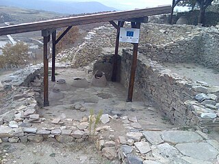
The Sacred pit of Garlo is an archaeological site located near the village of Garlo in Pernik District, Bulgaria.


