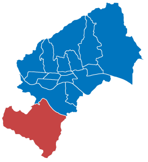
Brezovica is a city district of Zagreb, Croatia. It is located in the southwestern part of the city and has 12,030 inhabitants. It is one of the more rural districts in Zagreb. The A1 highway passes through Brezovica, although it has no exits there.
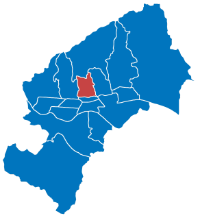
Gornji Grad–Medveščak is one of the districts of Zagreb, Croatia; "Gornji Grad" translates as "upper town", referring to its historical location on city's hillside, being above Donji grad. The district is located in the central part of the city and, according to the 2011 census, it has 30,962 inhabitants spread over 10.12 km2 (3.91 sq mi).

Podsused – Vrapče is one of the districts of Zagreb, Croatia. It is located in the north-western part of the city. In 2011, the district had 45,759 inhabitants. Its area is 36.188 km2.

Majur is a settlement and a municipality in central Croatia in the Sisak-Moslavina County. It has a population of 1,185, 70.04% of whom are Croats and 27.26% are ethnic Serbs.

Sveti Ivan Zelina is a town in Zagreb County, Croatia.
Žumberak is a village and a municipality in Croatia in the Zagreb County. According to the 2011 census, there are 883 inhabitants, 98% of which are Croats. Žumberak municipality covers an area of 110 km2 (42 sq mi).
Sirač is a settlement and municipality in Bjelovar-Bilogora County, Croatia. There are 2,218 inhabitants; 73% are Croats, 14% Serbs, and 11% Czechs. The following settlements make up the municipality: Barica, Bijela, Donji Borki, Gornji Borki, Kip, Miljanovac, Pakrani, Sirač, Šibovac.
Nova Kapela is a municipality in Brod-Posavina County, Croatia. There are 4,227 inhabitants in the following settlements:
Barilović is a village and a municipality in central Croatia, in the Karlovac County.
Donje Dubrave is a village in Karlovac County, Croatia. It is located in the municipality of Ogulin on the old Josephine Road connecting Duga Resa and Senj. The Rijeka-Zagreb railway passes through the village. It has 250 inhabitants, most of them working on the railway in the nearby cities of Ogulin and Karlovac. There is an elementary school in the village that was attended by five students until a few years ago. The school is currently closed and the students attend school in Ogulin and Generalski Stol.
Duboševica is a settlement in the region of Baranja, Croatia. Administratively, it is located in the Draž municipality within the Osijek-Baranja County. Population is 690 people.
Donji Desinec is a settlement in the Jastrebarsko administrative area of Zagreb County, Croatia. As of 2011 it had a population of 799.
Lokošin Dol is a settlement in the Jastrebarsko administrative area of Zagreb County, Croatia. As of 2011 it had a population of 95 people.
Malunje is a settlement in the Jastrebarsko administrative area of Zagreb County, Croatia. As of 2011 it had a population of 211 people.
Miladini is a settlement in the Jastrebarsko administrative area of Zagreb County, Croatia. As of 2011 it had a population of 58 people.
Prhoć is a settlement in the Jastrebarsko administrative area of Zagreb County, Croatia. As of 2011 it had a population of 235 people.
Slavetić is a settlement in the Jastrebarsko administrative area of Zagreb County, Croatia. As of 2011 it had a population of 84 people.
Stankovo, Croatia is a settlement in the Jastrebarsko administrative area of Zagreb County, Croatia. As of 2011 it had a population of 370 people.
Deanovec is a settlement in the Ivanić-Grad town of Zagreb County, Croatia. As of 2011 it had a population of 536 people.
Vrhovčak is a settlement (naselje) in the Samobor administrative territory of Zagreb County, Croatia. As of 2011 it had a population of 344 people.