Gornji Striževac | |
---|---|
Village | |
Coordinates: 43°07′06″N22°23′24″E / 43.11833°N 22.39000°E | |
Country | |
District | Šumadija |
Municipality | Babušnica |
Population (2002) | |
• Total | 154 |
Time zone | CET (UTC+1) |
• Summer (DST) | CEST (UTC+2) |
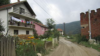
Gornji Striževac is a village in the municipality of Babušnica, Serbia. According to the 2002 census, the village has a population of 154 people. [1]
A village is a clustered human settlement or community, larger than a hamlet but smaller than a town, with a population ranging from a few hundred to a few thousand. Though villages are often located in rural areas, the term urban village is also applied to certain urban neighborhoods. Villages are normally permanent, with fixed dwellings; however, transient villages can occur. Further, the dwellings of a village are fairly close to one another, not scattered broadly over the landscape, as a dispersed settlement.
Babušnica is a town and municipality located in the Pirot District of south|eastern Serbia. According to 2011 census, the population of the town is 4,601, while population of the municipality is 12,307.
Serbia, officially the Republic of Serbia, is a country situated at the crossroads of Central and Southeast Europe in the southern Pannonian Plain and the central Balkans. The sovereign state borders Hungary to the north, Romania to the northeast, Bulgaria to the southeast, North Macedonia to the south, Croatia and Bosnia and Herzegovina to the west, and Montenegro to the southwest. The country claims a border with Albania through the disputed territory of Kosovo. Serbia's population is about seven million. Its capital, Belgrade, ranks among the oldest and largest citiеs in southeastern Europe.
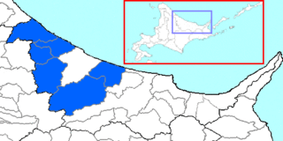
Monbetsu is a district located in Okhotsk Subprefecture, Hokkaido, Japan.
Konská is a village and municipality in Liptovský Mikuláš District in the Žilina Region of northern Slovakia.
Siodłkowice is a village in the administrative district of Gmina Wołów, within Wołów County, Lower Silesian Voivodeship, in south-western Poland. Prior to 1945 it was in Germany.
Bachdjerrah is a commune in Algiers Province and a suburb of the city of Algiers in northern Algeria. As of the 2008 census, the commune had a population of 93,289.
Coșbuc is a commune in Bistrița-Năsăud County, Romania. Since the village of Bichigiu was transferred to Telciu commune in 2004, Coșbuc remains the commune's only village.
Łopatki-Kolonia is a village in the administrative district of Gmina Wąwolnica, within Puławy County, Lublin Voivodeship, in eastern Poland.
Deszkowice-Kolonia is a village in the administrative district of Gmina Nielisz, within Zamość County, Lublin Voivodeship, in eastern Poland.
Drewniki is a village in the administrative district of Gmina Skierbieszów, within Zamość County, Lublin Voivodeship, in eastern Poland.
Budy Łękawickie is a village in the administrative district of Gmina Siennica, within Mińsk County, Masovian Voivodeship, in east-central Poland.
Skłody-Stachy is a village in the administrative district of Gmina Zaręby Kościelne, within Ostrów Mazowiecka County, Masovian Voivodeship, in east-central Poland.
Nowe Gralewo is a village in the administrative district of Gmina Raciąż, within Płońsk County, Masovian Voivodeship, in east-central Poland. It lies approximately 8 kilometres (5 mi) south of Raciąż, 21 km (13 mi) north-west of Płońsk, and 82 km (51 mi) north-west of Warsaw.
Stare Gralewo is a village in the administrative district of Gmina Raciąż, within Płońsk County, Masovian Voivodeship, in east-central Poland. It lies approximately 8 kilometres (5 mi) south of Raciąż, 21 km (13 mi) north-west of Płońsk, and 82 km (51 mi) north-west of Warsaw.
Łomów is a village in the administrative district of Gmina Zagórów, within Słupca County, Greater Poland Voivodeship, in west-central Poland.
Kraj is a small village located in the southeast part of the island of Pašman, 3 km south of the town of Pašman, 300 m from the coast of the Pašman Channel in Dalmatia, Croatia.
Kalâat el-Andalous is a town and commune in the Ariana Governorate, Tunisia. It is located 30 miles north of Tunis. As of 2004 it had a total population of 15,313.
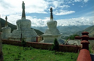
Nyang bran is a suburb district and valley located several kilometres north of the city of Lhasa, Tibet. The valley is noted for its hermitages, belonging to the Sera Monastery, one of the three great historical monasteries of Tibet. Pabonka Hermitage, Drakri Hermitage, Chupzang Nunnery and many others are located in the valley which offers scenic views of Lhasa. Mount Parasol lies on its western side on which the Pabonka Hermitage is located.
Koraćevac is a village in the municipality of Leskovac, Serbia. According to the 2002 census, the village has a population of 192 people.
Duhri is a village in the municipality of Kiseljak, Bosnia and Herzegovina.
Popovac is a village in the municipality of Veliko Gradište, Serbia. According to the 2002 census, the village has a population of 190 people.
Panglong is a village in Mu Se Township, Mu Se District, northern Shan State.
Coordinates: 43°07′06″N22°23′24″E / 43.11833°N 22.39000°E
A geographic coordinate system is a coordinate system that enables every location on Earth to be specified by a set of numbers, letters or symbols. The coordinates are often chosen such that one of the numbers represents a vertical position and two or three of the numbers represent a horizontal position; alternatively, a geographic position may be expressed in a combined three-dimensional Cartesian vector. A common choice of coordinates is latitude, longitude and elevation. To specify a location on a plane requires a map projection.
This Pirot District, Serbia location article is a stub. You can help Wikipedia by expanding it. |