
Mundaring is a suburb located 34 km east of Perth, Western Australia on the Great Eastern Highway. The suburb is located within the Shire of Mundaring.

Southern Cross is a town in Western Australia, 371 kilometres east of state capital Perth on the Great Eastern Highway. It was founded in 1888 after gold prospectors Richard Greaves and Ted Paine during their October 1887 expedition successfully found gold, and gazetted in 1890. It is the major town and administrative centre of the Shire of Yilgarn. At the 2016 census, Southern Cross had a population of 680.
Mount Helena is a suburb on the outskirts of Perth, in Western Australia, 35 km from the city, in the Shire of Mundaring. Its population in 2016 was 3,185 people.

The Eastern Railway is the main railway route between Fremantle and Northam in Western Australia. It opened in stages between 1881 and 1893. The line continues east to Kalgoorlie as the Eastern Goldfields Railway.

Bellevue is an eastern suburb of Perth, Western Australia in the local government areas of the City of Swan and the Shire of Mundaring. It is at the foot of the slopes of Greenmount, a landmark on the Darling Scarp that is noted in the earliest of travel journals of the early Swan River Colony.

The Helena River is a tributary of the Swan River in Western Australia. The river rises in country east of Mount Dale and flows north-west to Mundaring Weir, where it is dammed. It then flows west until it reaches the Darling Scarp.

The Railway Reserves Heritage Trail – also on some maps as Rail Reserve Heritage Trail or Rail Reserves Historical Trail, and frequently referred to locally as the Bridle Trail or Bridle Track – is within the Shire of Mundaring in Western Australia.

Glen Forrest is a suburb within the Shire of Mundaring, south of John Forrest National Park, west of Mahogany Creek, east of Darlington, and north of the Helena River. Its northern boundary is determined by the Great Eastern Highway.
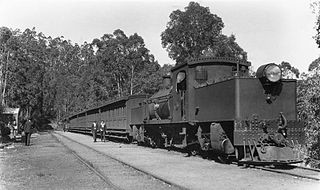
The Mundaring Weir branch railway was constructed from Mundaring, Western Australia to the site of the Mundaring Weir, and opened on 1 June 1898.

Chidlow is a small community in the Shire of Mundaring approximately 45 kilometres east of Perth, Western Australia.

Mundaring Weir is a concrete gravity dam located 39 kilometres (24 mi) from Perth, Western Australia in the Darling Scarp. The dam and reservoir form the boundary between the suburbs of Reservoir and Sawyers Valley. The dam impounds the Helena River.

Swan View is an eastern suburb of Perth, Western Australia. Its local government areas are the City of Swan and the Shire of Mundaring. It is 25 kilometres (16 mi) from Perth in the Perth Hills on the edge of the Darling Scarp, just to the west of the John Forrest National Park, east of Roe Highway and north of the Great Eastern Highway.
Bailup is a Western Australian locality and rural residential estate located 62 kilometres (39 mi) northeast of the state capital, Perth, along Toodyay Road. The population recorded at the 2021 census was 54. The area is split between the Shire of Toodyay and Shire of Mundaring, the latter of which contains most of the Bailup area.
Stoneville is a suburb east of Perth in the Shire of Mundaring, Western Australia. It is named after Edward Albert Stone, who was Chief Justice of Western Australia when the place was named in 1905. The name was chosen by the local residents, who were developing the district for fruit growing. The town's population is 2,050, with a median age of 36 years and 7.1% of residents aged over 65.

Sawyers Valley is sited on the Great Eastern Highway about 40 kilometres from Perth, Western Australia in the Shire of Mundaring. The community began as a sawmill and railway siding to process timber from the forest surrounding the Helena River to the south. Local employment included forest and Goldfields Water Supply Scheme maintenance, small orchards, and the Midland Railway Workshops. The suburb's name comes from the occupation of many of the first European settlers to the area in the 1860s, who were sawyers working at the local saw-pits. The Sawyers Valley Tavern, which sits on the Highway opposite the Railway Reserve Heritage Trail, was first established in 1882 and the Sawyers Valley railway station was built in 1884.

Hovea is a suburb in the Shire of Mundaring in Perth, Western Australia.

Beechina is a locality in the Shire of Mundaring in Western Australia. The word "Beechina" is the Nyungar name for a white gum valley to the northeast of the locality. It was first recorded by surveyor P. Chauncy in 1847, when he was carrying out the survey of the first road to Northam.

The Mundaring and Hills Historical Society (MHHS) is a local history society for the Shire of Mundaring, based in Mundaring, Western Australia.

The Shire of Mundaring is a local government area in eastern metropolitan Perth, the capital of Western Australia. The Shire covers an area of 645 square kilometres (249 sq mi) and had a population of approximately 38,000 as at the 2016 Census.

Bellevue railway station was a junction station on the Eastern Railway in the Perth suburb of Bellevue.
