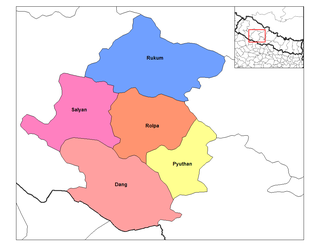
Rapti Zone was one of the fourteen zones, located in the Mid-Western Development Region of Nepal. It was named after the West Rapti River which drains Rolpa, Pyuthan and part of Dang districts. The remainder of Dang and part of Salyan district are drained by the Babai. The remainder of Salyan and all of Rukum districts are drained by the Bheri.

Rukum District was a "hill" and "mountain" district some 280 km (170 mi) west of Kathmandu partially belonging to Province No. 5 and partially to Karnali Pradesh before split into two districts Western Rukum and Eastern Rukum after the state's reconstruction of administrative divisions in 2017. Rukum covers an area of 2,877 km2 (1,111 sq mi) with population of 207,290 in 2011 Nepal census. Musikot was the district's administrative center.

Rukumkot is a town in a valley of the Rukum district in Nepal. Nearby is a pond called Rukmini Tal. There is an historic Shibalaya temple nearby. Other temples include the Barah, Baraji, and Bhagwati temples.
Rukum Chaurjahari Airport is an airport serving Chaurjahari, a municipality located in Western Rukum District of Karnali province of Nepal. The airport was renovated and the runway blacktopped in 2014 after previously only having a grass/clay runway.
Chaurjahari is a Municipality in Western Rukum District in Karnali province of Nepal that was established in 2015 through the merging the two former Village development committees Bijayaswori and Kotjahari. It lies on the bank of Sani Bheri River. At the time of the 2011 Nepal census it had a population of 27,438 people living in 5,422 individual households.
Duli is a Village Development Committee in Rukum District in the Rapti Zone of western Nepal. At the time of the 2011 Nepal census it had a population of 4837 people residing in 851 individual households.
Garayala is a village development committee in Rukum District in the Rapti Zone of western Nepal. At the time of the 1991 Nepal census it had a population of 5917 people living in 1116 individual households.
Ghetma is a village development committee in Rukum District in the Rapti Zone of western Nepal. At the time of the 2011 National Population and Housing Census it had a population of 4789 people in which 2348 male and 2441 female are living in 862 individual households.Here is a Higher Secondary School named Shree Adarsh Higher Secondary School Ghetma, Rukum which was established in 2030 B.S. as primary school and then upgraded as High School in 2057 B.S. at the same way it made Higher Secondary School in 2067 B.S. Each wards of it has primary Schools including 3 lower secondary Schools. It is located in bank of Thuli Bheri River from Bhalma to Rimna named places. Here is a locally famous cave named Saattale Guffa located in jungle of ward No.1. In past it was a part of Aathbis DandaGaun VDC which used to occupy 2 wards of it. Formerly it departed from that as one of small VDC in south-west area of Rukum district with the area of only around 29 km2.
Jang is a village development committee in Rukum District in the Rapti Zone of western Nepal. At the time of the 2011 Nepal census it had a population of 3084 people living in 578 individual households.
Kanda is a village development committee in Eastern Rukum District in Province No. 5 of western Nepal. At the time of the 1991 Nepal census it had a population of 2561 people living in 543 individual households.

Musikot is a municipality and the district headquarter of Western Rukum District in Karnali province of Nepal that was established on 18 May 2014 by merging the two former Village development committees Musikot and Khalanga. It lies on the bank of Sani Bheri River. It borders with Eastern Rukum in the east, Sanibheri rural municipality in the west, Banfikot rural municipality in the north and Tribeni rural municipality and Rolpa district in the south. Musikot was formerly called Musikot Khalanga and served as the district headquarter of Rukum District.
Pwang is a village development committee in Rukum District in the Rapti Zone of western Nepal. At the time of the 2011 Nepal census it had a population of 1802 people living in 359 individual households.
Pyaugha is a village development committee in Rukum District in the Rapti Zone of western Nepal. At the time of the 2011 Nepal census it had a population of 4595 people living in 819 individual households.
Simli is a village development committee in Rukum District in the Rapti Zone of western Nepal. At the time of the 2011 Nepal census it had a population of 5316 people living in 1044 individual households.
Syalapakha is a village development committee in Rukum District in the Rapti Zone of western Nepal. At the time of the 1991 Nepal census it had a population of 5433 people living in 1160 individual households.
Takasera is a village development committee in Rukum District in the Rapti Zone of western Nepal. At the time of the 2011 Nepal census it had a population of 3698 people living in 902 individual households. It has altogether 6 clustered villages in different locations within the Takasera VDC and the clustered village names are Taka, Upallo (upper) Sera, Lower (down) Sera, BachiGaun, Ghumlibang,Damchan and Tupa. As per the new federal government system, Takasera has been in the Putha Utterganga Rural Municipality (Ga.Pa.) wards being 10 and 11, in the Rukum Purba (East) district.

Eastern Rukum is a district located in Province No. 5 of Nepal. It is 1 out of 12 districts of the province. Rukumkot is the interim headquarter of the district. There was a decision of government to relocate the district headquarter from Rukumkot to Golkhada, Kol, Putha Uttarganga
Western Rukum a part of Karnali province, is one of the seventy-seven districts of Nepal. Musikot is the headquarter of the district.
Rukum Salle Airport, also known as Musikot Airport, is an airport serving Musikot Khalanga, a municipality located in the Southern region of Karnali Pradesh of Nepal. It was originally opened in 1994. The airport is one of two airports in Rukum District, the other one being Rukum Chaurjahari Airport. It serves as a main tourist gateway to Mount Sisne. The airport was renovated and the runway blacktopped in 2014 after previously only having a grass/clay runway.
