
Nzérékoré, (en-zeer-eh-core) also spelled N'Zérékoré, is the second largest city in Guinea by population, after the capital Conakry and the largest city in the Guinée forestière region of south-eastern Guinea. The city is the capital of the Nzérékoré Prefecture. Nzérékoré is a commercial and economic center and lies approximately 354 miles/569 km southeast of Conakry.

The Nzérékoré Region is a region in the southern part of Guinea. Its capital and largest city is Nzérékoré. It is one of the eight regions of Guinea. It is bordered by the countries of Sierra Leone, Liberia, and Ivory Coast, and the Guinean regions of Kankan and Faranah.

The Faranah Region is located in east-central Guinea. It is bordered by the countries of Sierra Leone and Mali and the Guinean regions of Kankan, Mamou, Nzérékoré, and Labé.

Mamou is a prefecture located in the Mamou Region of Guinea. The capital is Mamou. The prefecture covers an area of 8,000 km.² and has an estimated population of 222,000.

Dalaba is a prefecture located in the Mamou Region of Guinea. The capital is Dalaba. The prefecture covers an area of 4,400 km² and has an estimated population of 155,000.

Tougué is a prefecture located in the Labé Region of Guinea. The capital is Tougué. The prefecture covers an area of 6,400 km². and has an estimated population of 132,000.
Mali is a prefecture, also known as the Préfecture De Mali, located in the Labé Region of Guinea. The capital is Mali. The prefecture covers an area of 9,790 km.² and has an estimated population of 246,000.

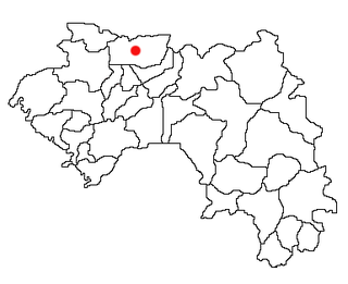
Labé is a prefecture in the Labé Region of Guinea. The capital is Labé. The prefecture covers an area of 3,014 km.² and has an estimated population of 204,000.

The Kindia Region is located in western Guinea. It is bordered by the country of Sierra Leone and the Guinean regions of Conakry, Labé, Mamou, and Boké.

The Labé Region is located in north-central Guinea. It is bordered by the countries of Senegal and Mali and the Guinean regions of Faranah, Kindia, Mamou, and Boké.

Lisso is a town and sub-prefecture in the Boffa Prefecture in the Boké Region of western Guinea. As of 2014 it had a population of 11,861 people.
Kaala is a town and sub-prefecture in the Dalaba Prefecture in the Mamou Region of western Guinea.
Sikhourou is a town and sub-prefecture in the Forécariah Prefecture in the Kindia Region of western Guinea.
Linko is a town and sub-prefecture in the Kérouané Prefecture in the Kankan Region of south-eastern Guinea. As of 2014 it had a population of 16,478 people.
Siguirini is a town and sub-prefecture in the Siguiri Prefecture in the Kankan Region of northern Guinea. As of 2014, the population in Siguirini was 54,953.
Koin, Guinea is a town and sub-prefecture in the Tougué Prefecture in the Labé Region of northern-central Guinea.
Kolangui is a town and sub-prefecture in the Tougué Prefecture in the Labé Region of northern-central Guinea.
Sarékaly is a town and sub-prefecture in the Télimélé Prefecture in the Kindia Region of western-central Guinea.
Sinta is a town and sub-prefecture in the Télimélé Prefecture in the Kindia Region of western-central Guinea.


