Gmina Dąbrowa Tarnowska is an urban-rural gmina in Dąbrowa County, Lesser Poland Voivodeship, in southern Poland. Its seat is the town of Dąbrowa Tarnowska, which lies approximately 76 kilometres (47 mi) east of the regional capital Kraków.
Gmina Bolesław is a rural gmina in Dąbrowa County, Lesser Poland Voivodeship, in southern Poland. Its seat is the village of Bolesław, which lies approximately 15 kilometres (9 mi) north-west of Dąbrowa Tarnowska and 73 km (45 mi) east of the regional capital Kraków.
Gmina Olesno is a rural gmina in Dąbrowa County, Lesser Poland Voivodeship, in southern Poland. Its seat is the village of Olesno, which lies approximately 7 kilometres (4 mi) north-west of Dąbrowa Tarnowska and 74 km (46 mi) east of the regional capital Kraków.
Gmina Szczucin is an urban-rural gmina in Dąbrowa County, Lesser Poland Voivodeship, in southern Poland. Its seat is the town of Szczucin, which lies approximately 16 kilometres (10 mi) north of Dąbrowa Tarnowska and 85 km (53 mi) east of the regional capital Kraków.

Świeciechów Duży is a village in the administrative district of Gmina Annopol, within Kraśnik County, Lublin Voivodeship, in eastern Poland. It lies approximately 7 kilometres (4 mi) north of Annopol, 26 km (16 mi) west of Kraśnik, and 61 km (38 mi) south-west of the regional capital Lublin.
Wojnowice is a village in the administrative district of Gmina Gidle, within Radomsko County, Łódź Voivodeship, in central Poland. It lies approximately 4 kilometres (2 mi) east of Gidle, 15 km (9 mi) south of Radomsko, and 94 km (58 mi) south of the regional capital Łódź.
Kupienin is a village in the administrative district of Gmina Mędrzechów, within Dąbrowa County, Lesser Poland Voivodeship, in southern Poland. It lies approximately 6 kilometres (4 mi) east of Mędrzechów, 15 km (9 mi) north of Dąbrowa Tarnowska, and 81 km (50 mi) east of the regional capital Kraków.
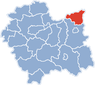
Mędrzechów is a village in Dąbrowa County, Lesser Poland Voivodeship, in southern Poland. It is the seat of the gmina called Gmina Mędrzechów. It lies approximately 14 kilometres (9 mi) north of Dąbrowa Tarnowska and 76 km (47 mi) east of the regional capital Kraków.
Odmęt is a village in the administrative district of Gmina Mędrzechów, within Dąbrowa County, Lesser Poland Voivodeship, in southern Poland. It lies approximately 16 kilometres (10 mi) north of Dąbrowa Tarnowska and 80 km (50 mi) east of the regional capital Kraków.
Wola Mędrzechowska is a village in the administrative district of Gmina Mędrzechów, within Dąbrowa County, Lesser Poland Voivodeship, in southern Poland.
Wólka Grądzka is a village in the administrative district of Gmina Mędrzechów, within Dąbrowa County, Lesser Poland Voivodeship, in southern Poland. It lies approximately 10 kilometres (6 mi) north of Dąbrowa Tarnowska and 77 km (48 mi) east of the regional capital Kraków.
Dąbrowica is a village in the administrative district of Gmina Szczucin, within Dąbrowa County, Lesser Poland Voivodeship, in southern Poland. It lies approximately 5 kilometres (3 mi) north-east of Szczucin, 20 km (12 mi) north-east of Dąbrowa Tarnowska, and 89 km (55 mi) east of the regional capital Kraków.
Łęka Szczucińska is a village in the administrative district of Gmina Szczucin, within Dąbrowa County, Lesser Poland Voivodeship, in southern Poland. It lies approximately 7 kilometres (4 mi) north-east of Szczucin, 22 km (14 mi) north-east of Dąbrowa Tarnowska, and 91 km (57 mi) east of the regional capital Kraków.
Maniów is a village in the administrative district of Gmina Szczucin, within Dąbrowa County, Lesser Poland Voivodeship, in southern Poland. It lies approximately 7 kilometres (4 mi) north-east of Szczucin, 22 km (14 mi) north-east of Dąbrowa Tarnowska, and 91 km (57 mi) east of the regional capital Kraków.
Książe-Skroniów is a village in the administrative district of Gmina Jędrzejów, within Jędrzejów County, Świętokrzyskie Voivodeship, in south-central Poland. It lies approximately 4 kilometres (2 mi) west of Jędrzejów and 37 km (23 mi) south-west of the regional capital Kielce.
Wojciechów is a village in the administrative district of Gmina Kazimierza Wielka, within Kazimierza County, Świętokrzyskie Voivodeship, in south-central Poland. It lies approximately 4 kilometres (2 mi) south-east of Kazimierza Wielka and 71 km (44 mi) south of the regional capital Kielce.
Czartoszowy is a village in the administrative district of Gmina Łopuszno, within Kielce County, Świętokrzyskie Voivodeship, in south-central Poland. It lies approximately 5 kilometres (3 mi) south of Łopuszno and 26 km (16 mi) west of the regional capital Kielce.
Mikołajowa is a village in the administrative district of Gmina Grodków, within Brzeg County, Opole Voivodeship, in south-western Poland. It lies approximately 8 kilometres (5 mi) west of Grodków, 27 km (17 mi) south-west of Brzeg, and 48 km (30 mi) west of the regional capital Opole.
Rychowo is a village in the administrative district of Gmina Białogard, within Białogard County, West Pomeranian Voivodeship, in north-western Poland. It lies approximately 12 kilometres (7 mi) south-west of Białogard and 102 km (63 mi) north-east of the regional capital Szczecin.