Grachyovsky District

Last updated
Location of Orenburg Oblast in Russia Map of Russia - Orenburg Oblast (2008-03).svg
Location of Orenburg Oblast in Russia
Location of Stavropol Krai in Russia Map of Russia - Stavropol Krai (2008-03).svg
Location of Stavropol Krai in Russia

Grachyovsky District is the name of several administrative and municipal districts in Russia.

Russia transcontinental country in Eastern Europe and Northern Asia

Russia, officially the Russian Federation, is a transcontinental country in Eastern Europe and North Asia. At 17,125,200 square kilometres (6,612,100 sq mi), Russia is by far or by a considerable margin the largest country in the world by area, covering more than one-eighth of the Earth's inhabited land area, and the ninth most populous, with about 146.77 million people as of 2019, including Crimea. About 77% of the population live in the western, European part of the country. Russia's capital, Moscow, is one of the largest cities in the world and the second largest city in Europe; other major cities include Saint Petersburg, Novosibirsk, Yekaterinburg and Nizhny Novgorod. Extending across the entirety of Northern Asia and much of Eastern Europe, Russia spans eleven time zones and incorporates a wide range of environments and landforms. From northwest to southeast, Russia shares land borders with Norway, Finland, Estonia, Latvia, Lithuania and Poland, Belarus, Ukraine, Georgia, Azerbaijan, Kazakhstan, China, Mongolia and North Korea. It shares maritime borders with Japan by the Sea of Okhotsk and the U.S. state of Alaska across the Bering Strait. However, Russia recognises two more countries that border it, Abkhazia and South Ossetia, both of which are internationally recognized as parts of Georgia.

Grachyovsky District, Orenburg Oblast District in Orenburg Oblast, Russia

Grachyovsky District is an administrative and municipal district (raion), one of the thirty-five in Orenburg Oblast, Russia. The area of the district is 1,700 square kilometers (660 sq mi). Its administrative center is the rural locality of Grachyovka. Population: 13,495 ; 16,198 (2002 Census); 15,946 (1989 Census). The population of Grachyovka accounts for 45.4% of the total district's population.

Orenburg Oblast First-level administrative division of Russia

Orenburg Oblast is a federal subject of Russia. Its administrative center is the city of Orenburg. From 1938 to 1957, it bore the name Chkalov Oblast in honor of Valery Chkalov. Population: 2,033,072.

Grachyovsky District, Stavropol Krai District in Stavropol Krai, Russia

Grachyovsky District is an administrative district (raion), one of the twenty-six in Stavropol Krai, Russia. Municipally, it is incorporated as Grachyovsky Municipal District. It is located in the western central part of the krai. The area of the district is 1,794 square kilometers (693 sq mi). Its administrative center is the rural locality of Grachyovka. Population: 36,272 (2010 Census); 36,110 ; 31,970. The population of Grachyovka accounts for 18.4% of the district's total population.

See also

Related Research Articles

Kirovsky District is the name of several administrative and municipal divisions in Russia. The districts are generally named for Sergey Kirov, a Soviet statesman.

Alexandrovsky District is the name of several administrative and municipal districts in Russia. The district names are generally derived from or related to the male first name Alexander.

Kursky District Wikimedia list article

Kursky District is the name of several administrative and municipal districts in Russia:

Petrovsky District, Russia Wikipedia disambiguation page

Petrovsky District is the name of several administrative and municipal districts in Russia. The districts' name generally derives from or is related to the male first name Pyotr.

Novopavlovsk Town in Stavropol Krai, Russia

Novopavlovsk is a town and the administrative center of Kirovsky District in Stavropol Krai, Russia, located on the left bank of the Kura River. Population: 26,562 (2010 Census); 23,235 (2002 Census); 18,589 (1989 Census).

Krasnogvardeysky District is the name of several administrative and municipal districts in Russia. The districts are generally named for the Red Guards—paramilitary formations which took active part in the 1917 Russian Revolution and the Russian Civil War and later re-organized into the Red Army.

Alexandrovsky District, Stavropol Krai District in Stavropol Krai, Russia

Alexandrovsky District is an administrative district (raion), one of the twenty-six in Stavropol Krai, Russia. Municipally, it is incorporated as Alexandrovsky Municipal District. It is located in the center of the krai. The area of the district is 2,014 square kilometers (778 sq mi). Its administrative center is the rural locality of Alexandrovskoye. Population: 50,235 (2010 Census); 50,978 ; 49,434. The population of Alexandrovskoye accounts for 54.7% of the district's total population.

Andropovsky District District in Stavropol Krai, Russia

Andropovsky District is an administrative district (raion), one of the twenty-six in Stavropol Krai, Russia. Municipally, it is incorporated as Andropovsky Municipal District. It is located in the southwest of the krai. The area of the district is 2,388 square kilometers (922 sq mi). Its administrative center is the rural locality of Kursavka. Population: 35,437 (2010 Census); 35,670 ; 32,216. The population of Kursavka accounts for 33.4% of the district's total population.

Blagodarnensky District District in Stavropol Krai, Russia

Blagodarnensky District is an administrative district (raion), one of the twenty-six in Stavropol Krai, Russia. Municipally, it is incorporated as Blagodarnensky Municipal District. It is located in the center of the krai. The area of the district is 2,471 square kilometers (954 sq mi). Its administrative center is the town of Blagodarny. Population: 62,047 (2010 Census); 66,172 ; 54,211. The population of Blagodarny accounts for 52.7% of the district's total population.

Izobilnensky District District in Stavropol Krai, Russia

Izobilnensky District is an administrative district (raion), one of the twenty-six in Stavropol Krai, Russia. Municipally, it is incorporated as Izobilnensky Municipal District. It is located in the west of the krai. The area of the district is 1,935 square kilometers (747 sq mi). Its administrative center is the town of Izobilny. Population: 103,635 (2010 Census); 101,980 ; 87,036. The population of Izobilny accounts for 39.1% of the district's total population.

Kirovsky District, Stavropol Krai District in Stavropol Krai, Russia

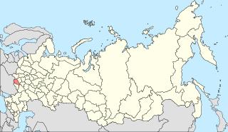
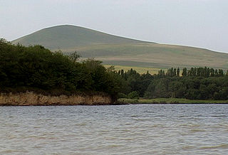
Kirovsky District is an administrative district (raion), one of the twenty-six in Stavropol Krai, Russia. Municipally, it is incorporated as Kirovsky Municipal District. It is located in the south of the krai. The area of the district is 1,386 square kilometers (535 sq mi). Its administrative center is the town of Novopavlovsk. Population: 71,723 (2010 Census); 67,317 ; 55,074. The population of Novopavlovsk accounts for 37.0% of the district's total population.

Kochubeyevsky District District in Stavropol Krai, Russia

Kochubeyevsky District is an administrative district (raion), one of the twenty-six in Stavropol Krai, Russia. Municipally, it is incorporated as Kochubeyevsky Municipal District. It is located in the southwest of the krai. The area of the district is 2,363 square kilometers (912 sq mi). Its administrative center is the rural locality of Kochubeyevskoye. Population: 79,557 (2010 Census); 81,609 ; 69,512. The population of Kochubeyevskoye accounts for 33.7% of the district's total population.

Neftekumsky District District in Stavropol Krai, Russia

Neftekumsky District is an administrative district (raion), one of the twenty-six in Stavropol Krai, Russia. Municipally, it is incorporated as Neftekumsky Municipal District. It is located in the east of the krai. The area of the district is 3,797 square kilometers (1,466 sq mi). Its administrative center is the town of Neftekumsk. Population: 68,778 (2010 Census); 70,902 ; 59,775. The population of Neftekumsk accounts for 40.3% of the district's total population.

Novoalexandrovsky District District in Stavropol Krai, Russia

Novoalexandrovsky District is an administrative district (raion), one of the twenty-six in Stavropol Krai, Russia. Municipally, it is incorporated as Novoalexandrovsky Municipal District. It is located in the west of the krai. The area of the district is 2,015 square kilometers (778 sq mi). Its administrative center is the town of Novoalexandrovsk. Population: 65,477 (2010 Census); 67,065 ; 58,630. The population of Novoalexandrovsk accounts for 40.9% of the district's total population.

Novoselitsky District District in Stavropol Krai, Russia

Novoselitsky District is an administrative district (raion), one of the twenty-six in Stavropol Krai, Russia. Municipally, it is incorporated as Novoselitsky Municipal District. It is located in the center of the krai. The area of the district is 1,724 square kilometers (666 sq mi). Its administrative center is the rural locality of Novoselitskoye. Population: 26,697 (2010 Census); 26,613 ; 23,021. The population of Novoselitskoye accounts for 32.7% of the district's total population.

Predgorny District District in Stavropol Krai, Russia

Predgorny District is an administrative district (raion), one of the twenty-six in Stavropol Krai, Russia. Municipally, it is incorporated as Predgorny Municipal District. It is located in the south of the krai. The area of the district is 2,047 square kilometers (790 sq mi). Its administrative center is the rural locality of Yessentukskaya. Population: 106,775 (2010 Census); 104,391 ; 90,955. The population of Yessentukskaya accounts for 18.9% of the district's total population.

Sovetsky District, Stavropol Krai District in Stavropol Krai, Russia

Sovetsky District is an administrative district (raion), one of the twenty-six in Stavropol Krai, Russia. Municipally, it is incorporated as Sovetsky Municipal District. It is located in the south of the krai. The area of the district is 2,089 square kilometers (807 sq mi). Its administrative center is the town of Zelenokumsk. Population: 62,790 (2010 Census); 72,762 ; 64,993. The population of Zelenokumsk accounts for 57.1% of the district's population.

Stepnovsky District District in Stavropol Krai, Russia

Stepnovsky District is an administrative district (raion), one of the twenty-six in Stavropol Krai, Russia. Municipally, it is incorporated as Stepnovsky Municipal District. It is located in the southeast of the krai. The area of the district is 1,887 square kilometers (729 sq mi). Its administrative center is the rural locality of Stepnoye. Population: 22,192 (2010 Census); 23,315 ; 19,520. The population of Stepnoye accounts for 25.3% of the district's total population.

Trunovsky District District in Stavropol Krai, Russia

Trunovsky District is an administrative district (raion), one of the twenty-six in Stavropol Krai, Russia. Municipally, it is incorporated as Trunovsky Municipal District. It is located in the northwest of the krai. The area of the district is 1,686 square kilometers (651 sq mi). Its administrative center is the rural locality of Donskoye. Population: 34,558 (2010 Census); 35,403 ; 32,093. The population of Donskoye accounts for 43.2% of the district's total population.

References

  1. Законодательное Собрание Оренбургской области. Закон №1370/276-IV-ОЗ от 11 июля 2007 г. «Об административно-территориальном устройстве Оренбургской области», в ред. Закона №2826/783-V-ОЗ от 15 декабря 2014 г. «О внесении изменений в Закон Оренбургской области "Об административно-территориальном устройстве Оренбургской области"». Вступил в силу после официального опубликования. Опубликован: "Южный Урал", №№134–135 (спецвыпуск №40 с документами Законодательного Собрания Оренбургской области), 21 июля 2007 г. (Legislative Assembly of Orenburg Oblast. Law #1370/276-IV-OZ of July 11, 2007 On the Administrative-Territorial Structure of Orenburg Oblast, as amended by the Law #2826/783-V-OZ of December 15, 2014 On Amending the Law of Orenburg Oblast "On the Administrative-Territorial Structure of Orenburg Oblast". Effective as of after the official publication date.).
  2. Законодательное Собрание Оренбургской области. Закон №2367/495-IV-ОЗ от 15 сентября 2008 г. «Об утверждении перечня муниципальных образований Оренбургской области и населённых пунктов, входящих в их состав», в ред. Закона №3322/917-V-ОЗ от 24 августа 2015 г. «О внесении изменений в Закон Оренбургской области "Об утверждении перечня муниципальных образований Оренбургской области и населённых пунктов, входящих в их состав"». Вступил в силу через 10 дней после официального опубликования. Опубликован: "Бюллетень Законодательного Собрания Оренбургской области", 22 заседание, I часть, 29 августа 2008 г. (Legislative Assembly of Orenburg Oblast. Law #2367/495-IV-OZ of September 15, 2008 On Adopting the Registry of the Municipal Formations of Orenburg Oblast and the Inhabited Localities They Comprise, as amended by the Law #3322/917-V-OZ of August 24, 2015 On Amending the Law of Orenburg Oblast "On Adopting the Registry of the Municipal Formations of Orenburg Oblast and the Inhabited Localities They Comprise". Effective as of after 10 days following the official publication.).
  3. Государственная Дума Ставропольского края. №6-кз 12 октября 1994 г. «Устав (Основной Закон) Ставропольского края», в ред. Закона №132-кз от 2 декабря 2015 г. «О поправках к Уставу (Основному Закону) Ставропольского края». Опубликован: "Ставропольская правда", №198–199, 14 октября 1994 г. (State Duma of Stavropol Krai. #6-kz October 12, 1994 Charter (Basic Law) of Stavropol Krai, as amended by the Law #132-kz of December 2, 2015 On the Amendments to the Charter (Basic Law) of Stavropol Krai. ).
  4. Государственная Дума Ставропольского края. Закон №89-кз от 4 октября 2004 г. «Об установлении границ муниципальных районов Ставропольского края», в ред. Закона №51-кз от 28 мая 2015 г. «О преобразовании муниципальных образований, входящих в состав Минераловодского муниципального района Ставропольского края (Минераловодского территориального муниципального образования Ставропольского края), и об организации местного самоуправления на территории Минераловодского района Ставропольского края». Вступил в силу со дня официального опубликования. Опубликован: "Ставропольская правда", №216, 6 октября 2004 г. (State Duma of Stavropol Krai. Law #89-kz of October 4, 2004 On Establishing the Borders of the Municipal Districts of Stavropol Krai, as amended by the Law #51-kz of May 28, 2015 On the Transformation of the Municipal Formations Within Mineralovodsky Municipal District of Stavropol Krai (Mineralovodskoye Territorial Municipal Formation of Stavropol Krai), and on the Organization of the Local Self-Government on the Territory of Mineralovodsky District of Stavropol Krai. Effective as of the day of the official publication.).