Related Research Articles

Old Red Sandstone, abbreviated ORS, is an assemblage of rocks in the North Atlantic region largely of Devonian age. It extends in the east across Great Britain, Ireland and Norway, and in the west along the eastern seaboard of North America. It also extends northwards into Greenland and Svalbard. These areas were a part of the paleocontinent of Euramerica (Laurussia). In Britain it is a lithostratigraphic unit to which stratigraphers accord supergroup status and which is of considerable importance to early paleontology. The presence of Old in the name is to distinguish the sequence from the younger New Red Sandstone which also occurs widely throughout Britain.

The geology of Great Britain is renowned for its diversity. As a result of its eventful geological history, Great Britain shows a rich variety of landscapes across the constituent countries of England, Wales and Scotland. Rocks of almost all geological ages are represented at outcrop, from the Archaean onwards.

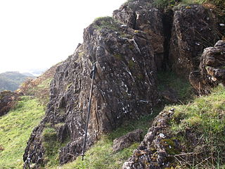
The Highland Boundary Fault is a major fault zone that traverses Scotland from Arran and Helensburgh on the west coast to Stonehaven in the east. It separates two different geological terranes which give rise to two distinct physiographic terrains: the Highlands and the Lowlands, and in most places it is recognisable as a change in topography. Where rivers cross the fault, they often pass through gorges, and the associated waterfalls can be a barrier to salmon migration.
The Dalradian Supergroup is a stratigraphic unit in the lithostratigraphy of the Grampian Highlands of Scotland and in the north and west of Ireland. The diverse assemblage of rocks which constitute the supergroup extend across Scotland from Islay in the west to Fraserburgh in the east and are confined by the Great Glen Fault to the northwest and the Highland Boundary Fault to the southeast. Much of Shetland east of the Walls Boundary Fault is also formed from Dalradian rocks. Dalradian rocks extend across the north of Ireland from County Antrim in the north east to Clifden on the Atlantic coast, although obscured by later Palaeogene lavas and tuffs or Carboniferous rocks in large sections.

The Argyll Group is a thick sequence of metamorphosed Neoproterozoic sedimentary rocks that outcrop across the Central Highlands of Scotland, east of the Great Glen, as well as appearing in the north of Ireland. It is a subdivision of the Dalradian Supergroup and is itself divided into four units; from oldest to youngest these are the Islay, Easdale, Crinan and Tayvallich subgroups.
The Lias Group or Lias is a lithostratigraphic unit found in a large area of western Europe, including the British Isles, the North Sea, the Low Countries and the north of Germany. It consists of marine limestones, shales, marls and clays.

The Moine Supergroup is a sequence of Neoproterozoic metamorphic rocks that form the dominant outcrop of the Scottish Highlands between the Moine Thrust Belt to the northwest and the Great Glen Fault to the southeast. The sequence is metasedimentary in nature and was metamorphosed and deformed in a series of tectonic events during the Late Proterozoic and Early Paleozoic. It takes its name from A' Mhòine, a peat bog in northern Sutherland.

The Hebridean Terrane is one of the terranes that form part of the Caledonian orogenic belt in northwest Scotland. Its boundary with the neighbouring Northern Highland Terrane is formed by the Moine Thrust Belt. The basement is formed by Archaean and Paleoproterozoic gneisses of the Lewisian complex, unconformably overlain by the Neoproterozoic Torridonian sediments, which in turn are unconformably overlain by a sequence of Cambro–Ordovician sediments. It formed part of the Laurentian foreland during the Caledonian continental collision.

The Pembroke Limestone Group is a stratigraphic unit of Courceyan to Brigantian age found in southern Wales and northern Somerset. It forms part of the Carboniferous Limestone Supergroup. These carbonate rocks developed in platform and ramp environments and are up to 1025m thick in places.
This article describes the geology of the New Forest, a national park in Hampshire, in Southern England.

The Appin Group is a thick sequence of metamorphosed Neoproterozoic sedimentary rocks that outcrop across the Central Highlands of Scotland, east of the Great Glen. It forms a part of the Dalradian Supergroup.

The Southern Highland Group is a sequence of metamorphosed Neoproterozoic sedimentary rocks that outcrop across the Central Highlands of Scotland, east of the Great Glen. It forms the uppermost/youngest part of the Dalradian Supergroup and is divided into two formations. Volcanism is recorded by the Loch Avich Lavas Formation which divides the Loch Avich Grits Formation into lower and upper parts – the grits are turbidite and submarine fan deposits. In Perthshire and on Deeside, the Leny Limestone, which has been dated to 514 Ma, is present. A tillite, the Macduff Boulder Bed is known from the upper part of the group in northeast Scotland.
The Badenoch Group is a sequence of metamorphosed Tonian age sedimentary rocks that outcrop across the Central Highlands of Scotland, east of the Great Glen. This rock sequence has formerly been referred to as the Central Highland Migmatite Complex and the Central Highland Division.
This article describes the geology of the Cairngorms National Park, an area in the Highlands of Scotland designated as a national park in 2003 and extended in 2010. The Cairngorms National Park extends across a much wider area than the Cairngorms massif itself and hence displays rather more varied geology.

The Durness Group is a geological group, a carbonate-dominated stratigraphic unit that forms a c. 170 km long narrow and discontinuous outcrop belt along the north-western coast of Scotland from the Isle of Skye and Loch Kishorn in the south to Durness and Loch Eriboll in the north. It forms the youngest part of the foreland basin of the Moine Thrust Belt in the Scottish Northwest Highlands and is incorporated into this belt's lowermost thrust sheets, where it is often affected by thrust faulting. It overlies the Ardvreck Group.
The geology of national parks in Britain strongly influences the landscape character of each of the fifteen such areas which have been designated. There are ten national parks in England, three in Wales and two in Scotland. Ten of these were established in England and Wales in the 1950s under the provisions of the National Parks and Access to the Countryside Act 1949. With one exception, all of these first ten, together with the two Scottish parks were centred on upland or coastal areas formed from Palaeozoic rocks. The exception is the North York Moors National Park which is formed from sedimentary rocks of Jurassic age.
The geology of Loch Lomond and The Trossachs National Park in the southwestern part of the Scottish Highlands consists largely of Neoproterozoic and Palaeozoic bedrock faulted and folded and subjected to low grade metamorphism during the Caledonian orogeny. These older rocks, assigned to the Dalradian Supergroup, lie to the northwest of the northeast – southwest aligned Highland Boundary Fault which defines the southern edge of the Highlands. A part of this mountainous park extends south of this major geological divide into an area characterised by younger Devonian rocks which are assigned to the Old Red Sandstone.

The Loch Ness Supergroup is one of the subdivisions of the Neoproterozoic sequence of sedimentary rocks in the Scottish Highlands. It is found everywhere in tectonic contact above the older Wester Ross Supergroup. It is thought to be unconformably overlain by the Cryogenian to Cambrian Dalradian Supergroup.
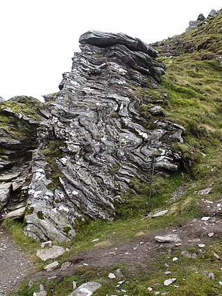
The Highland Border Complex is an assemblage of rocks of probable early Cambrian to late Ordovician age, found as fault-bounded blocks of variable lithology exposed immediately to the southeast of the Highland Boundary Fault at the edge of the Grampian Highlands, Scotland.
References
- ↑ "BGS Lexicon of Named Rock Units - Result Details". Bgs.ac.uk. Retrieved 18 January 2019.
- ↑ Strachan, R.A., Harris, A.L., Fettes, D.J. & Smith, M. 2002 The Highland and Grampian Terranes. In: Trewin, N.H. (ed) The Geology of Scotland. The Geological Society, London, pp. 96-99