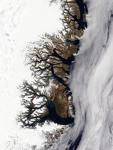
Grandjean Fjord | |
---|---|
Location in Greenland | |
Location | Arctic |
Coordinates | 75°0′N21°30′W / 75.000°N 21.500°W Coordinates: 75°0′N21°30′W / 75.000°N 21.500°W |
Ocean/sea sources | Hochstetter Bay Greenland Sea |
Basin countries | Greenland |
Max. length | 75 kilometres (47 mi) |
Max. width | 5 kilometres (3.1 mi) |
Frozen | Most of the year |
Islands | Ulla Island |
Grandjean Fjord is a fjord in King Christian X Land, East Greenland. Administratively it is part of the Northeast Greenland National Park zone.
Geologically, a fjord or fiord is a long, narrow inlet with steep sides or cliffs, created by a glacier. There are many fjords on the coasts of Alaska, Antarctica, British Columbia, Chile, Greenland, the Faroe Islands, Iceland, Kamchatka, the Kerguelen Islands, New Zealand, Norway, Novaya Zemlya, Labrador, Nunavut, Newfoundland, Quebec, Scotland, South Georgia Island, and Washington state. Norway's coastline is estimated at 29,000 kilometres (18,000 mi) with nearly 1,200 fjords, but only 2,500 kilometres (1,600 mi) when fjords are excluded.
King Christian X Land is an area of northeastern Greenland.
Greenland is the world's largest island, located between the Arctic and Atlantic oceans, east of the Canadian Arctic Archipelago. It is an autonomous territory within the Kingdom of Denmark. Though physiographically a part of the continent of North America, Greenland has been politically and culturally associated with Europe for more than a millennium. The majority of its residents are Inuit, whose ancestors migrated from Alaska through Northern Canada, gradually settling across the island by the 13th century. Nowadays the population is largely concentrated on the southwest coast of the island while the rest of the island is sparsely populated. Greenland is divided into five municipalities — Sermersooq, Kujalleq, Qeqertalik, Qeqqata, and Avannaata. It has two unincorporated areas — the Northeast Greenland National Park and the Thule Air Base. The last one, even if under Danish control, is administered by the United States Air Force.
This fjord was mapped in 1932 during the Three-year Expedition to East Greenland led by Lauge Koch. In August of the same year it was surveyed by Gunnar Seidenfaden. Koch named it after Commander Emil Valdemar Asger Grandjean (1889–1948), then chief of the Royal Danish Navy Air Service [1]
The Three-year Expedition was an exploratory expedition to East Greenland that lasted from 1931 to 1934 financed by the Carlsberg Foundation and the Danish state. The expedition included aerial surveys.
Lauge Koch was a Danish geologist and Arctic explorer.
Grandjean Fjord opens to the east, between Cape Negri to the south and Cape Buch to the north. Its mouth opens in the northwestern area of Hochstetter Bay, by the northern entrance of Fligely Fjord, northwest of Kuhn Island and south of the mouth area of Ardencaple Fjord. [1] The fjord separates Thomas Thomsen Land in the south from C. H. Ostenfeldland to the north.Ulla Island rises in the middle of mouth area of the fjord, about 7 kilometres (4.3 mi) from the entrance. [2]
Hochstetter Bay is a broad bay in northeastern Greenland. It is part of the Northeast Greenland National Park area.
Fligely Fjord is a fjord in King Christian X Land, East Greenland. Administratively it is part of the Northeast Greenland National Park zone.
Kuhn Island is a coastal island in Hochstetter Bay, eastern Greenland. There are coal deposits on the island.
The fjord is about 5 kilometres (3.1 mi) wide at the mouth and stretches to the southwest for about 35 kilometres (22 mi), curving northwestwards and narrowing to about 3 kilometres (1.9 mi) in its inner half where the Heinkel Glacier flows into the head. There are high mountains on both sides of the fjord. [3] Betulahavn is a bay in the SW side of the central stretch of the fjord. [1]
![]() | ![]() |
Danmark Fjord, also known as Denmark Sound, is a fjord in northeast Greenland within Northeast Greenland National Park.
Kaiser Franz Joseph Fjord is a major fjord system in the NE Greenland National Park area, East Greenland.
Bessel Fjord is a fjord in northeastern Greenland. Administratively it belongs to the NE Greenland National Park area.
Romer Lake is a land-locked freshwater fjord at the northern end of King Frederick VIII Land, near Greenland's northeastern coast. The Danish military base/weather station Nord —the only inhabited place in the area— lies 50 km (31 mi) to the northeast. The lake and its surroundings are part of the Northeast Greenland National Park zone.
The Denmark expedition, also known as Denmark Expedition to Greenland's Northeast Coast, and as the Danmark Expedition after the ship, was an expedition to the northeast of Greenland in 1906–1908.
Ardencaple Fjord is a fjord in King Christian X Land, northeastern Greenland. Administratively it is part of the Northeast Greenland National Park.
Bessel Fjord, also known as Bessels Bay, is a fjord in northwestern Greenland. Administratively it belongs to the Avannaata municipality.
The Roosevelt Range or Roosevelt Mountains is a mountain range in Northern Greenland. Administratively this range is part of the Northeast Greenland National Park. Its highest peak is the highest point in Peary Land.
Nordvestfjord, meaning 'Northwest Fjord', is a fjord in King Christian X Land, eastern Greenland.
The Dijmphna Sound is a sound in King Frederick VIII Land, Northeast Greenland. Administratively it is part of the Northeast Greenland National Park zone.
Carlsberg Fjord is a fjord in King Christian X Land, eastern Greenland.
Peters Bay is a bay of the Greenland Sea in King Christian X Land, Greenland. Administratively it belongs to the NE Greenland National Park area.
Fleming Fjord is a fjord in King Christian X Land, eastern Greenland.
Dusen Fjord or Dusén Fjord is a fjord in the NE Greenland National Park area, East Greenland.
Godthab Gulf, also known as Godthaab Golf, Clavering Fjord, Clavering Sound and Inner Bay, is a fjord in King Christian X Land, East Greenland. Administratively it is part of the Northeast Greenland National Park zone.
Young Sound is a marine channel with a fjord structure in King Christian X Land, East Greenland. Administratively it is part of the Northeast Greenland National Park zone.
Lindeman Fjord is a fjord in King Christian X Land, East Greenland. Administratively it is part of the Northeast Greenland National Park zone.
Tyrolerfjord is a fjord in King Christian X Land, East Greenland. Administratively it is part of the Northeast Greenland National Park zone.
Nansen Land is a peninsula in far northwestern Greenland. It is a part of the Northeast Greenland National Park.
![]() | This Greenland location article is a stub. You can help Wikipedia by expanding it. |