Grange Arch

Last updated
Grange Arch

Grange Arch looking NW.JPG

Grange Arch on Ridgeway Hill
Alternative names Creech Folly
General information
Type Folly
Location Ridgeway Hill, Dorset, UK
Country United Kingdom
Coordinates 50°38′08″N2°07′30″W / 50.6356°N 2.1249°W / 50.6356; -2.1249 Coordinates: 50°38′08″N2°07′30″W / 50.6356°N 2.1249°W / 50.6356; -2.1249
Elevation ~198 m
Client Denis Bond

Grange Arch, also known as Creech Folly, is an 18th-century folly that is located near the second highest point of the Purbeck Hills, Ridgeway Hill (199 m), in Dorset. It lies within the parish of Steeple.

Folly architectural structure characterized by a certain excess in terms of eccentricity, cost, or conspicuous inutility; often found in gardens or parks

In architecture, a folly is a building constructed primarily for decoration, but suggesting through its appearance some other purpose, or of such extravagant appearance that it transcends the range of garden ornaments usually associated with the class of buildings to which it belongs.

Purbeck Hills hill in the United Kingdom

The Purbeck Hills, also called the Purbeck Ridge, are a ridge of chalk downs in Dorset, England. The ridge extends from Lulworth Cove in the west to Old Harry Rocks in the east, where it meets the sea. The hills are part of a system of chalk downlands in southern England formed from the Chalk Group which also includes Salisbury Plain and the South Downs. For most of their length the chalk of the Purbeck Hills is protected from coastal erosion by a band of resistant Portland limestone. Where this band ends, at Durlston Head, the clay and chalk behind has been eroded, creating Poole Bay and the Solent. The ridge of steeply dipping chalk that forms the Purbeck Hills continues further east on the Isle of Wight.

Ridgeway Hill mountain in United Kingdom

Ridgeway Hill, also referred to as Grange Hill or Steeple Hill, is the third highest point of the Purbeck Hills in the county of Dorset standing at 199 metres (653 ft), is one of the only hills with a prominence of over a hundred metres, HuMPs, in the county. Near the top of the hill is an 18th-century folly known as Grange Arch, built by the former owner of Creech Grange, Denis Bond. On the eastern spur of the hill is Stonehill Down which is now a nature reserve. There are also good views of Swyre Head on the Jurassic Coast.

The folly, which was built by a former owner of Creech Grange, Denis Bond, in 1746, is built in the form of a triple arch of ashlar stone. The central archway is surmounted by battlements and flanked by stone walls with smaller doorway arches. [1] [2]

Creech Grange country house in Steeple, Dorset, England

Creech Grange is an elegant country house in Steeple, south of Wareham in Dorset at the foot of the Purbeck Hills. Historic England designate it as a Grade I listed building. The park and gardens are Grade II* listed in the National Register of Historic Parks and Gardens.

Ashlar Finely dressed stone and associated masonry

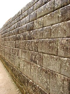
Ashlar is finely dressed stone, either an individual stone that has been worked until squared or the structure built of it. Ashlar is the finest stone masonry unit, generally cuboid, mentioned by Vitruvius as opus isodomum, or less frequently trapezoidal. Precisely cut "on all faces adjacent to those of other stones", ashlar is capable of very thin joints between blocks, and the visible face of the stone may be quarry-faced or feature a variety of treatments: tooled, smoothly polished or rendered with another material for decorative effect.

Today the arch is owned by the National Trust. [1] English Heritage have designated it a Grade II* listed building. [3]

English Heritage charity responsible for the National Heritage Collection of England

English Heritage is a charity that manages over 400 historic monuments, buildings and places. These include prehistoric sites, medieval castles, Roman forts and country houses. The charity states that it uses these properties to ‘bring the story of England to life for over 10 million people each year’.

See also

Related Research Articles

Kimmeridge a village located in Purbeck, United Kingdom

Kimmeridge is a small village and civil parish on the Isle of Purbeck, a peninsula on the English Channel coast in Dorset, England. It is situated about 4.5 miles (7.2 km) south of Wareham and 7 miles (11 km) west of Swanage, in the Purbeck administrative district. In 2013 the estimated population of the civil parish was 90.

Purbeck District Non-metropolitan district in England

Purbeck was a local government district in Dorset, England. The district was named after the Isle of Purbeck, a peninsula that forms a large proportion of the district's area. However it extended significantly further north and west than the traditional boundary of the Isle of Purbeck along the River Frome. The district council was based in the town of Wareham, which is itself north of the River Frome.

Alton, Wiltshire

Alton is a civil parish in Wiltshire, England. The parish includes the adjacent villages of Alton Barnes and Alton Priors, and the nearby hamlet of Honeystreet on the Kennet and Avon Canal. It lies in the Vale of Pewsey about 6 miles (10 km) east of Devizes.

Steeple, Dorset village in the United Kingdom

Steeple is a hamlet and former civil parish, now in the civil parish of Steeple with Tyneham, in the Purbeck district of the English county of Dorset. It is situated 8 miles (13 km) west of the coastal resort town of Swanage at the foot of Ridgeway Hill. In 2013 the estimated population of the civil parish was 60. The civil parish was abolished on 1 April 2014 and merged with Tyneham to form Steeple with Tyneham.

Winterbourne Abbas village in United Kingdom

Winterborne Abbas is a village and civil parish in south west Dorset, England, situated in a valley on the A35 road 5 miles (8.0 km) west of Dorchester. In the 2011 census the parish had a population of 355.

Tyneham former civil parish and ghost village in south Dorset, England

Tyneham is a ghost village and former civil parish, now in the civil parish of Steeple with Tyneham, in south Dorset, England, near Lulworth on the Isle of Purbeck. In 2001 the civil parish had a population of 0. The civil parish was abolished on 1 April 2014 and merged with Steeple to form Steeple with Tyneham.

Coleby, North Kesteven village and civil parish in North Kesteven, Lincolnshire, England

Coleby is a village and civil parish in the North Kesteven district of Lincolnshire, England. It is situated on the A607, and approximately 6 miles (10 km) south from the city and county town of Lincoln.

Stanton, Gloucestershire village in Tewkesbury Borough, Gloucestershire, England

Stanton is a village and civil parish in Tewkesbury Borough, Gloucestershire, England. The village is a spring line settlement at the foot of the Cotswold escarpment, about 2 12 miles (4 km) southwest of Broadway in neighbouring Worcestershire. Broadway is Stanton's postal town. The 2011 Census recorded the parish's population as 198.

Avoncliff Aqueduct bridge in United Kingdom

Avoncliff Aqueduct carries the Kennet and Avon Canal over the River Avon and the Bath to Westbury railway line, at Avoncliff in Wiltshire, England. It was built by John Rennie and chief engineer John Thomas, between 1797 and 1801. It is a Grade II* listed building.

Clent Castle

Clent Castle is a sham ruin castellated folly in the grounds of Clent Grove that is situated opposite the Fountain Inn on Adams Hill in Clent, Worcestershire, England. It was built in the late 18th century by Thomas Liell, and it has been designated by English Heritage as a Grade II listed building.

Bell Hill, Dorset mountain in United Kingdom

At 258 metres, Bell Hill is one of the highest hills in the county of Dorset, England and a high point on the Wessex Ridgeway.

Dorset Heaths

The Dorset Heaths form an important area of heathland within the Poole Basin in southern England. Much of the area is protected.

Creech Barrow Hill

Creech Barrow Hill is a steep, conical hill, 193 metres (633 ft) high, near the coast of Dorset, England, and the highest point of the Dorset Heaths. It has been described as "one of Dorset's most distinctive landmarks." Geologically, it is also the highest Cenozoic hill in England.

Povington Hill

Povington Hill, at 198 metres (650 ft) high, is one of the highest points on the chain of the Purbeck Hills in south Dorset on the southern coast of England. Its prominence of 107 metres (351 ft) means it is listed as one of the Tumps, although map sources suggest this honour should go to Ridgeway Hill further east.

Stonehill Down Nature Reserve

The Stonehill Down Nature Reserve is a downland nature reserve on the Purbeck Hills in the county of Dorset, England. It is managed by the Dorset Wildlife Trust.

East Creech village in the United Kingdom

East Creech is a hamlet in the county of Dorset in England.

References

  1. 1 2 Grange Arch on the Purbeck ridgeway at www.geograph.org.uk. Accessed on 26 May 2013.
  2. Grange Arch, Steeple at www.britishlistedbuildings.co.uk. Accessed on 26 May 2013.
  3. Historic England. "Grange Arch (1120456)". National Heritage List for England . Retrieved 16 June 2014.