Creech Grange

Last updated

Creech Grange
Creech Grange - geograph.org.uk - 1223893.jpg
Creech Grange
Creech Grange
General information
Type Country house, manor house
Location Steeple, Dorset, UK
CountryUnited Kingdom
Coordinates 50°38′25″N2°07′38″W / 50.6403°N 2.12722°W / 50.6403; -2.12722 Coordinates: 50°38′25″N2°07′38″W / 50.6403°N 2.12722°W / 50.6403; -2.12722
Construction started1540
Completed1559
ClientSir Oliver Lawrence

Creech Grange is an elegant country house in Steeple, south of Wareham in Dorset at the foot of the Purbeck Hills. Historic England designate it as a Grade I listed building. [1] The park and gardens are Grade II* listed in the National Register of Historic Parks and Gardens. [2]

Contents

History

The house was built by Sir Oliver Lawrence (1507–1559), who acquired the land from the former Bindon Abbey, near Wool, after Henry VIII had abolished the monasteries in 1539. Lawrence was the brother-in-law of Henry's Lord Chancellor, Thomas Wriothesley, 1st Earl of Southampton.

Lawrence was an ancestor of the first American president, George Washington, and the joint arms of the two families - the famous stars and stripes of Washington's signet ring and the American flag - appear in memorials at Steeple and Affpuddle.

Creech Grange was sold to Nathaniel Bond in 1691, [3] and the family still hold their Purbeck estates. It was Thomas Bond who in Stuart times laid out the famous London Street over fields of swamp and refuse tips and lost a fortune.

Only fragments remain of the original house built by Lawrence before his death in 1559, partly because it was damaged by fire by the Parliamentarians during the English Civil War, and finally because in 1846 the entire front was taken down and rebuilt in the local Tudor style.

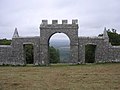
In 1746, Denis Bond erected a folly known as Grange Arch on the highest local point on the Purbeck Ridge, Ridgeway Hill (199 m). The folly is now owned by the National Trust. Creech Grange is not to be confused with neighbouring East Creech Manor that was in the possession of Walter Le Franke in 1224 and passed down through his family to Mary Franke in 1637, who married Edmund Hayter (d. 1657), and was sold out of that family in 1770.

View

There are panoramic views from nearby Creech Barrow Hill. Though part of the Purbeck Hills, Creech Barrow stands out, detached. The church tower of Lady St Mary in the old town of Wareham stands proud. Poole Harbour assumes dominance as the view moves north-easterly, its southern shore dominated by the deep green of Rempstone Forest. After the blur of the Poole/Bournemouth conurbation, the ruins of Corfe Castle conclude the sweep as the eastern view disappears into the Purbeck Ridge.

SSSI

Part of the estate is a 0.1-hectare (0.25-acre) biological Site of Special Scientific Interest, notified in 1977. The outbuildings are an important roosting site for Greater Horseshoe Bats. [4]

Related Research Articles

Kimmeridge Human settlement in England

Kimmeridge is a small village and civil parish on the Isle of Purbeck, a peninsula on the English Channel coast in Dorset, England. It is situated about 4.5 miles (7.2 km) south of Wareham and 7 miles (11 km) west of Swanage. In 2013 the estimated population of the civil parish was 90.

Wareham, Dorset Human settlement in England

Wareham is a historic market town and, under the name Wareham Town, a civil parish, in the English county of Dorset. The town is situated on the River Frome eight miles (13 km) southwest of Poole.

Purbeck District Non-metropolitan district in England

Purbeck was a local government district in Dorset, England. The district was named after the Isle of Purbeck, a peninsula that forms a large proportion of the district's area. However, it extended significantly further north and west than the traditional boundary of the Isle of Purbeck which is the River Frome. The district council was based in the town of Wareham, which is itself north of the Frome.

Steeple, Dorset Human settlement in England

Steeple is a hamlet and former civil parish, now in the civil parish of Steeple with Tyneham, in the Purbeck district of the English county of Dorset. It is situated 8 miles (13 km) west of the coastal resort town of Swanage at the foot of Ridgeway Hill. In 2013 the estimated population of the civil parish was 60. The civil parish was abolished on 1 April 2014 and merged with Tyneham to form Steeple with Tyneham.

Arne, Dorset Human settlement in England

Arne is a village and civil parish in Dorset, England, situated 4 miles (6.4 km) east of Wareham. The local travel links are located at Wareham railway station. Bournemouth International Airport is 11 miles (18 km) away. The main road through the village is Arne Road connecting Arne to Wareham. The village is situated on the Arne Peninsula, which protrudes into Poole Harbour opposite the town of Poole.

Tyneham Human settlement in England

Tyneham is a ghost village and former civil parish, now in the civil parish of Steeple with Tyneham, in south Dorset, England, near Lulworth on the Isle of Purbeck. In 2001 the civil parish had a population of 0. The civil parish was abolished on 1 April 2014 and merged with Steeple to form Steeple with Tyneham.

Purbeck Hills Chalk ridge in England

The Purbeck Hills, also called the Purbeck Ridge or simply the Purbecks, are a ridge of chalk downs in Dorset, England. It is formed by the structure known as the Purbeck Monocline. The ridge extends from Lulworth Cove in the west to Old Harry Rocks in the east, where it meets the sea. The hills are part of a system of chalk downlands in southern England formed from the Chalk Group which also includes Salisbury Plain and the South Downs. For most of their length the chalk of the Purbeck Hills is protected from coastal erosion by a band of resistant Portland limestone. Where this band ends, at Durlston Head, the clay and chalk behind has been eroded, creating Poole Bay and the Solent. The ridge of steeply dipping chalk that forms the Purbeck Hills continues further east on the Isle of Wight.

Furzebrook Railway

The Furzebrook Railway, also known as the Pike Brothers' Tramway, was a narrow gauge industrial railway on the Isle of Purbeck in the English county of Dorset. It was built by the Pike Brothers, to take Purbeck Ball Clay from their clay pits near Furzebrook and West Creech to a wharf at Ridge on the River Frome.

Denis Bond (1676–1747), of Creech Grange, Dorset, was English lawyer and Whig politician who sat in the House of Commons between 1709 and 1732, when he was expelled for financial misconduct.

Nathaniel Bond

Nathaniel Bond KS, of Creech Grange in the Isle of Purbeck, Dorset, was an English lawyer and Member of Parliament.

Robert Culliford was an English landowner and politician who sat in the House of Commons from 1660 to 1679.

Ridgeway Hill Hill in Dorset, England

Ridgeway Hill, also referred to as Grange Hill or Steeple Hill, is the third highest point of the Purbeck Hills in the county of Dorset standing at 199 metres (653 ft), is one of the only hills with a prominence of over a hundred metres, HuMPs, in the county. Near the top of the hill is an 18th-century folly known as Grange Arch, built by the former owner of Creech Grange, Denis Bond. On the eastern spur of the hill is Stonehill Down which is now a nature reserve. There are also good views of Swyre Head on the Jurassic Coast.

Bell Hill, Dorset

At 258 metres, Bell Hill is one of the highest hills in the county of Dorset, England and a high point on the Wessex Ridgeway.

Dorset Heaths

The Dorset Heaths form an important area of heathland within the Poole Basin in southern England. Much of the area is protected.

Povington Hill Hill in Dorset, England

Povington Hill, at 198 metres (650 ft) high, is one of the highest points on the chain of the Purbeck Hills in south Dorset on the southern coast of England. Its prominence of 107 metres (351 ft) means it is listed as one of the Tumps, although map sources suggest this honour should go to Ridgeway Hill further east.

Grange Arch

Grange Arch, also known as Creech Folly, is an 18th-century folly that is located near the second highest point of the Purbeck Hills, Ridgeway Hill, in Dorset. It lies within the parish of Steeple.

Stonehill Down Nature Reserve

The Stonehill Down Nature Reserve is a downland nature reserve on the Purbeck Hills in the county of Dorset, England. It is managed by the Dorset Wildlife Trust.

East Creech Human settlement in England

East Creech is a hamlet in the parish of Church Knowle in the county of Dorset, England.

References

  1. Historic England. "Creech Grange (1304916)". National Heritage List for England . Retrieved 15 June 2014.
  2. Historic England. "Creech Grange (1000532)". National Heritage List for England. Retrieved 11 February 2016.
  3. John Ferris, ‘Bond, Nathaniel (1634–1707)’, Oxford Dictionary of National Biography, Oxford University Press, 2004 accessed 25 Oct 2009
  4. English Nature citation sheet for the site (accessed 29 August 2006)