The Royal Society for the Protection of Birds (RSPB) is a charitable organisation registered in England and Wales and in Scotland. It was founded in 1889. It works to promote conservation and protection of birds and the wider environment through public awareness campaigns, petitions and through the operation of nature reserves throughout the United Kingdom.
The Wildfowl & Wetlands Trust (WWT) is an international wildfowl and wetland conservation charity in the United Kingdom.

RSPB Leighton Moss is a nature reserve in Lancashire, England, which has been in the care of the Royal Society for the Protection of Birds since 1964. It is situated near Silverdale, Carnforth, on the edge of Morecambe Bay and in the Arnside and Silverdale Area of Outstanding Natural Beauty.

Fairburn Ings Nature Reserve is a protected area in West Yorkshire, England, noted for its avian biodiversity. The reserve has recorded around 280 bird species, remarkable for an inland site in the United Kingdom. This is explained by the site being on migration routes as well as the diversity of habitats.

The Isle of Portland is a tied island, 6 kilometres (4 mi) long by 2.7 kilometres (1.7 mi) wide, in the English Channel. The southern tip, Portland Bill, lies 8 kilometres (5 mi) south of the resort of Weymouth, forming the southernmost point of the county of Dorset, England. A barrier beach called Chesil Beach joins Portland with mainland England. The A354 road passes down the Portland end of the beach and then over the Fleet Lagoon by bridge to the mainland. The population of Portland is 13,417.

Weymouth and Portland was a local government district with borough status in Dorset, England from 1974 to 2019. It consisted of the resort of Weymouth and the Isle of Portland, and includes the areas of Wyke Regis, Preston, Melcombe Regis, Upwey, Broadwey, Southill, Nottington, Westham, Radipole, Chiswell, Castletown, Fortuneswell, Weston, Southwell and Easton; the latter six being on the Isle of Portland.

The River Wey is a chalk stream flowing through Dorset in south west England.

Melcombe Regis is an area of Weymouth in Dorset, England. Situated on the north shore of Weymouth Harbour and originally part of the waste of Radipole, it seems only to have developed as a significant settlement and seaport in the 13th century.

Radipole is a suburb of Weymouth in Dorset, England.

Southill, Weymouth is a modern suburb of Weymouth, Dorset, England, and lies about 2 miles (3 km) north of the town centre. It was developed on the western shore of Radipole Lake in several phases from the 1960s onwards.

Thatcham Reed Beds is a 67.4-hectare (167-acre) biological Site of Special Scientific Interest east of Newbury in Berkshire. It is part of the Kennet & Lambourn Floodplain Special Area of Conservation and an area of 14 hectares is a Local Nature Reserve. An area of 35 hectares is managed by the Berkshire, Buckinghamshire and Oxfordshire Wildlife Trust.

Lodmoor is a Site of Special Scientific Interest (SSSI), RSPB reserve and country park in Dorset, England. The country park features a visitor centre, model railway and pitch and putt golf course. The SSSI has a wetland habitat with native birds that are rare in the UK and a range of migratory species.
Weymouth is a seaside town and civil parish in the Dorset district, in the ceremonial county of Dorset, England. Situated on a sheltered bay at the mouth of the River Wey, 7 miles (11 km) south of the county town of Dorchester, Weymouth had a population of 53,416 in 2021. It is the third-largest settlement in Dorset after Bournemouth and Poole.

Fore Wood is a 20.9-hectare (52-acre) biological Site of Special Scientific Interest north-west of Hastings in East Sussex. It is part of the Royal Society for the Protection of Birds nature reserve of the same name, and the land designated as Fore Wood SSSI is entirely owned by the Royal Society for the Protection of Birds.
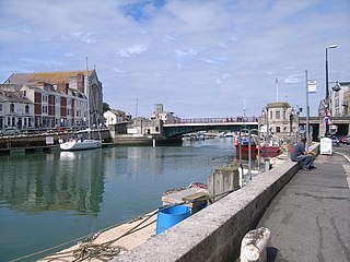
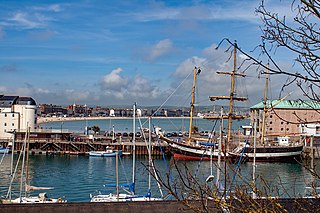
Weymouth Harbour is a harbour at the seaside town of Weymouth in Dorset, southern England. It has a 17th-century waterfront.

Rye Meads is a 58.5-hectare (145-acre) biological Site of Special Scientific Interest (SSSI) in Rye House, Hoddesdon, Hertfordshire. It is one of series of wetlands and reservoirs situated along the River Lea, to the north-east of London. It is part of the Lea Valley Ramsar site and a Special Protection Area.

Forsinard Flows is a national nature reserve (NNR) covering much of the area surrounding Forsinard in the Highland council area of Scotland. It lies at the heart of the Flow Country, a large, rolling expanse of peatland and wetland area of Caithness and Sutherland that makes up almost 5% of the world's blanket bog. The reserve is managed by the Royal Society for the Protection of Birds (RSPB), and is designated a Category II protected area by the International Union for Conservation of Nature. Much of the NNR overlaps with the designated area of the Caithness and Sutherland Peatlands Special Protection Area and Special Area of Conservation.

Sandlings Forest is a 2,483.8 hectare biological Site of Special Scientific Interest in two large blocks, Rendlesham Forest and Tunstall Forest, and two small ones, between Woodbridge and Aldeburgh in Suffolk. It is partly in the Sandlings Special Protection Area under the European Union Directive on the Conservation of Wild Birds. It is in the Suffolk Coast and Heaths Area of Outstanding Natural Beauty.

Many parts of Scotland are protected in accordance with a number of national and international designations because of their environmental, historical or cultural value. Protected areas can be divided according to the type of resource which each seeks to protect. NatureScot has various roles in the delivery of many environmental designations in Scotland, i.e. those aimed at protecting flora and fauna, scenic qualities and geological features. Historic Environment Scotland is responsible for designations that protect sites of historic and cultural importance. Some international designations, such as World Heritage Sites, can cover both categories of site.

South Thames Estuary and Marshes is a 5,289-hectare (13,070-acre) biological Site of Special Scientific Interest which stretches between Gravesend and the mouth of the River Medway in Kent. Part of it is a Nature Conservation Review site, Grade I, and part is a Royal Society for the Protection of Birds nature reserve. It is part of the Thames Estuary and Marshes Ramsar internationally important wetland site and Special Protection Area under the European Union Directive on the Conservation of Wild Birds.


