
Prescott is a city in and the county seat of Yavapai County, Arizona, United States. As of 2020 Census, the city's population was 45,827.

The Salt River is a river in Gila and Maricopa counties in Arizona, United States, that is the largest tributary of the Gila River. The river is about 200 miles (320 km) long. Its drainage basin covers about 13,700 square miles (35,000 km2). The longest of the Salt River's many tributaries is the 195-mile (314 km) Verde River. The Salt's headwaters tributaries, the Black River and East Fork, increase the river's total length to about 300 miles (480 km). The name Salt River comes from the river's course over large salt deposits shortly after the merging of the White and Black Rivers.
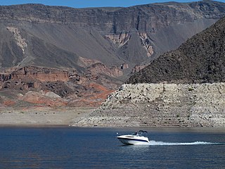
Lake Mead National Recreation Area is a U.S. national recreation area in southeastern Nevada and northwestern Arizona. Operated by the National Park Service, Lake Mead NRA follows the Colorado River corridor from the westernmost boundary of Grand Canyon National Park to just north of the cities of Laughlin, Nevada and Bullhead City, Arizona. It includes all of the eponymous Lake Mead as well as the smaller Lake Mohave – reservoirs on the river created by Hoover Dam and Davis Dam, respectively – and the surrounding desert terrain and wilderness.

The Verde River is a major tributary of the Salt River in the U.S. state of Arizona. It is about 170 miles (270 km) long and carries a mean flow of 602 cubic feet per second (17.0 m3/s) at its mouth. It is one of the largest perennial streams in Arizona.

The City of Rocks National Reserve, also known as the Silent City of Rocks, is a United States National Reserve and state park in south-central Idaho, approximately 2 miles (3.2 km) north of the border with Utah. It is widely known for its enormous granite rock formations and excellent rock climbing.

The Tahoe Rim Trail (TRT) is a 170-mile (274 km) long-distance hiking trail that forms a loop around the Lake Tahoe Basin in the Sierra Nevada and ranges of Nevada and California in the United States. The trail ranges in elevation from 6,223 feet at the outlet of Lake Tahoe to 10,338 feet at Relay Peak in Nevada. About 50 miles (80 km) of trail above the lake's west shore are also part of the national Pacific Crest Trail. Additionally, 96 Miles of the trail along the east and south sides of the Lake Tahoe basin are designated as a National Recreation Trail.

The Prescott National Forest is a 1.25 million-acre United States National Forest located in north central Arizona in the vicinity of Prescott. The forest is located in the mountains southwest of Flagstaff and north of Phoenix in Yavapai County, with a small portion extending into southwestern Coconino County.

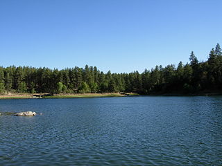
Lynx Lake, Arizona, is a 55-acre (220,000 m2) reservoir located within Prescott National Forest, approximately 5 miles (8.0 km) east of Prescott, Arizona, in the Bradshaw Mountains. The lake is located at 5,530 feet (1,690 m) elevation and is stocked for fishing. It is one of the most popular recreation areas in central Arizona. Mild weather, the cool ponderosa pine forest, trout fishing, boating, mountain hiking, horseback riding, archaeological sites, and bird watching attract visitors from throughout Arizona. The lake was formed in 1952, when a dam was put in Lynx Creek, 6 miles (9.7 km) below Walker, Arizona.

The Agua Fria River is a 120-mile (190 km) long intermittent stream which flows generally south from 20 miles (32 km) east-northeast of Prescott in the U.S. state of Arizona. Prescott draws much of its municipal water supply from the upper Agua Fria watershed. The Agua Fria runs through the Agua Fria National Monument. The river then flows through a small canyon called "Black Canyon" into Lake Pleasant, a popular recreation area near Peoria, Arizona. (There is a large "Black Canyon" on the Colorado River along the Arizona–Nevada border.)
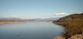
Theodore Roosevelt Lake is a large reservoir formed by Theodore Roosevelt Dam on the Salt River in Arizona as part of the Salt River Project (SRP). Located roughly 80 miles (130 km) northeast of Phoenix in the Salt River Valley, Theodore Roosevelt is the largest lake or reservoir located entirely within the state of Arizona. The reservoir and the masonry dam that created it, Roosevelt Dam, were both named after U.S. President Theodore Roosevelt who dedicated the dam himself on March 18, 1911. Roosevelt Lake is a popular recreation destination within the Tonto National Forest; the facilities located at this lake are managed by that authority.
Goldwater Lake is a reservoir formed by a dam on Banning Creek, located south of Prescott in North Central Arizona. This lake is maintained by the City of Prescott Parks and Recreation Department. The park has facilities for picnicking, fishing, boating, hiking, volleyball, and horseshoes.
The Bradshaw Mountains are a mountain range in central Arizona, United States, named for brothers Isaac and William D. Bradshaw after their deaths, having been formerly known in English as the Silver Mountain Range.

Watson Lake is one of two reservoirs at the Granite Dells, in Prescott, Arizona, that was formed in the early 1900s when the Chino Valley Irrigation District built a dam on Granite Creek. The City of Prescott bought the reservoir and surrounding land in 1997 to preserve it as recreational land. Local rockclimbers use the granite cliffs above and adjacent to the lake for top-roping and lead climbing. The lake is also the home of TriCity Prep Rowing Crew, a local high school team and only rowing team in Northern Arizona.

Granite Mountain is a 7,628-foot (2,325 m) mountain located in Yavapai County, Arizona that covers roughly 12 square miles (31 km2). It was once known as Mount Gurley, for the first governor of the Arizona Territory, John A. Gurley. Its southwest face has a sheer granite cliff approximately 500 feet high that is one of the best locations for rock climbing in the state of Arizona. It is located in the Granite Mountain Wilderness, which is managed as a part of the Prescott National Forest. The mountain stands at the northern end of the Sierra Prietas, and borders Skull Valley on the west, on the northwest by the Santa Maria Mountains, and east by the Williamson Valley.
The Granite Dells is a geological feature north of Prescott, Arizona. The Dells consist of exposed bedrock and large boulders of granite that have eroded into an unusual lumpy, rippled appearance. Watson Lake and Willow Lake are small man-made reservoirs in this formation.

Horsethief Basin Lake is a reservoir in the Bradshaw Mountains and the Prescott National Forest, in central Arizona, United States. It is located near Crown King in eastern Yavapai County. Fish species present include Bluegill, Largemouth Bass, Channel Catfish, and Muskie.

Lonesome Valley is a 23-mile (37 km) long valley located in central-north Yavapai County, Arizona; the valley is an extension southeastwards from Chino Valley (Arizona), the location of the Big Chino Wash, which becomes the Verde River at Paulden, Arizona; Paulden is located at the northwest terminus of Lonesome Valley. A small sub-valley is located on the northeast perimeter of Chino Valley, Arizona, located in the center-northwest of Lonesome Valley. The valley is named Little Chino Valley, and is the small valley link between Chino Valley, northwest, and Lonesome Valley, southeast.
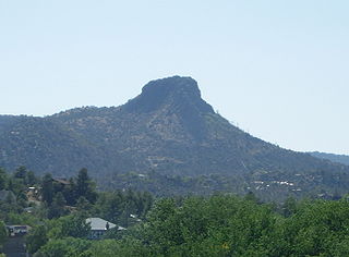
The Sierra Prieta is a 14 miles (23 km) long mountain range in central-northwest Arizona. The range is the mountainous region west of Prescott, with prominent Thumb Butte, 6,514 feet (1,985 m), a volcanic plug, on the city's west perimeter.

Granite Creek is a 38-mile (61 km) tributary of the Verde River in the U.S. state of Arizona. It flows generally north-northeast from the Bradshaw Mountains of west-central Arizona through the city of Prescott and the Granite Dells to meet the river at the north end of the Little Chino Valley east of Sullivan Lake.
Falcon Nest is a detached residence in Prescott, Arizona, that is the tallest single family home in North America at 124 feet (38 m). Its name is attributed to its resemblance to a large mountainside bird's nest and the peregrine falcons that inhabit the area. It is located in Yavapai County, approximately a two-hour drive northwest of Arizona's capitol, Phoenix.

