
Yosemite National Park is well known for its granite domes:
Yosemite National Park is well known for its granite domes:

Tuolumne Meadows is a gentle, dome-studded, sub-alpine meadow area along the Tuolumne River in the eastern section of Yosemite National Park in the United States. Its approximate location is 37°52.5′N119°21′W. Its approximate elevation is 8,619 feet (2,627 m). The term Tuolumne Meadows is also often used to describe a large portion of the Yosemite high country around the meadows, especially in context of rock climbing.

Lembert Dome is a granite dome rock formation in Yosemite National Park in the US state of California. The dome soars 800 feet (240 m) above Tuolumne Meadows and the Tuolumne River and can be hiked starting at the Tioga Road in the heart of Tuolumne Meadows, 8 miles (13 km) west of the Tioga Pass Entrance to Yosemite National Park. The landform is an example of a rôche moutonnée with clear lee and stoss slopes.
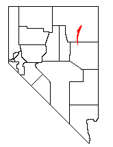
The Ruby Mountains are a mountain range, primarily located within Elko County with a small extension into White Pine County, in Nevada, United States. Most of the range is included within the Humboldt-Toiyabe National Forest. The range reaches a maximum elevation of 11,387 feet (3,471 m) on the summit of Ruby Dome. To the north is Secret Pass and the East Humboldt Range, and from there the Rubies run south-southwest for about 80 miles (130 km). To the east lies Ruby Valley, and to the west lie Huntington and Lamoille Valleys. The Ruby Mountains are the only range of an introduced bird, the Himalayan snowcock, in North America.

Liberty Cap is a granite dome in Yosemite National Park, California, United States which lies at the extreme northwestern margin of Little Yosemite Valley. It lies adjacent, to the north of Nevada Fall, on the John Muir Trail. It rises 1,700 feet (520 m) feet from the base of Nevada Fall to a peak elevation of 7,080 ft (2,158 m). A smaller, mesa-like dome called Mount Broderick stands immediately adjacent to Liberty Cap.

Arc Dome is the highest mountain of the Toiyabe Range in northwestern Nye County, Nevada, United States. It is the thirteenth-highest mountain in the state. Arc Dome also ranks as the second-most topographically prominent peak in Nye County and the eighth-most prominent peak in the state. The peak is located about 53 miles (85 km) north of the community of Tonopah, within the Arc Dome Wilderness of the Humboldt-Toiyabe National Forest.

Pothole Dome is a granite dome on the west side of Tuolumne Meadows, in Yosemite National Park located at Tioga Road mile marker 18. Near Pothole Dome is Marmot Dome. The summit of the dome is easily accessible by foot from a parking area on the Tioga Road at mile marker 18. The view from the summit includes most of Tuolumne Meadows and in the distance, Cathedral Peak. The dome gives evidence of many of the geologic processes at work in Yosemite during and after the last ice age. In particular, the stranded, rounded boulders from a glacier that has long since retreated, and the water-eroded "potholes" provide evidence of two ways that water can interact with granite.

Fairview Dome is a prominent granite dome in Yosemite National Park, located 1.8 miles (2.9 km) north of Cathedral Peak and 4 miles (6.4 km) west of Tuolumne Meadows. Near Fairview Dome is Marmot Dome, linked by an area called Razor Back. Northwest is Hammer Dome.

Daff Dome or DAFF Dome is a prominent 800 feet (243.8 m) granite dome in Yosemite National Park, 3 miles (4.8 km) west of Tuolumne Meadows and 1,700 feet (0.5 km) from the Tioga Road. It is southeast of Doda Dome, and is near both West Cottage Dome and East Cottage Dome; it is also near Lamb Dome. Since the dome was never officially named, the DAFF Dome name was adopted in 1960's as an acronym of "Dome Across From Fairview" Dome.

Polly Dome is a prominent granite dome rising 1,640 feet (500 m) above the northwest side of Tenaya Lake and Tioga Road in the Yosemite high country. The dome, more than 3 kilometers long, is a substantially intact mass of granitic rock that has withstood heavy glaciation and exfoliation. Forest clings to the less-steep parts of its north and west slopes. The southwest end of Polly Dome consists of the Stately Pleasure Dome, 740 feet (230 m) lower than Polly Dome, but rising very steeply 900 feet (270 m) from the shore of the lake. Polly Dome's summit has unobstructed views east to the Cathedral Range, north over Tuolumne Meadows to the Sierra crest, northwest over the Grand Canyon of the Tuolumne and southwest to Half Dome.

Stately Pleasure Dome is the unofficial name for the prominent south-southwestern portion of Polly Dome, a granite dome on the northwest side of Tenaya Lake and Tioga Road in the Yosemite high country. Stately Pleasure Dome consists of glaciated and exfoliated granite rock that rises steeply 900 feet (270 m) from the lake shore; the very steep east side of the dome is popular with rock climbers, who gave the dome its name.

Medlicott Dome is a prominent granite dome in Yosemite high country. It is located on the southeast side of Tioga Road, between Mariolumne Dome and Dozier Dome, near Pywiack Dome, the Cathedral lakes, Drug Dome, East Cottage Dome, West Cottage Dome, North and South Whizz Domes, and Fairview Dome. It is popular with climbers, hikers and backpackers due to relative ease of access and ascent, as well as scenic views of Yosemite.
Hiking, rock climbing, and mountain climbing around Tuolumne Meadows in Yosemite National Park has many options.
Dozier Dome is a granite dome, in the Tuolumne Meadows region of Yosemite National Park. It is named after Jeff Dozier.
Mariolumne Dome is a granite dome, in the Tuolumne Meadows region of Yosemite National Park.

Mammoth Peak is a mountain, in the area of Tuolumne Meadows, Yosemite National Park, California. The summit is an easy hike.
Drug Dome is a granite dome in the Tuolumne Meadows area of Yosemite National Park. Drug Dome is just west of Fairview Dome. It is also near Mariolumne Dome, Lamb Dome and Medlicott Dome.
Hammer Dome, is a granite dome in the Tuolumne Meadows area of Yosemite National Park. Hammer Dome is a bit north, of Cathedral Creek, which has its source, near Cathedral Peak. Hammer Dome is loosely northwest of Fairview Dome, is north of both Medlicott Dome and Pywiack Dome, all three of which are south of California State Route 120, which runs through Tuolumne Meadows to Tioga Pass. North and South Whizz Domes are close.
North Whizz Dome is a granite dome in the Tuolumne Meadows area of Yosemite National Park. North Whizz Dome is a bit south, of Cathedral Creek, which has its source, near Cathedral Peak. North Whizz Dome Dome is north of both Medlicott Dome and Pywiack Dome, both of which are south of California State Route 120, which runs through Tuolumne Meadows to Tioga Pass. It is near Hammer Dome, also, Daff Dome and Polly Dome are nearby.
South Whizz Dome is a granite dome in the Tuolumne Meadows area of Yosemite National Park. South Whizz Dome is a bit south, of Cathedral Creek, which has its source, near Cathedral Peak. South Whizz Dome Dome is north of both Medlicott Dome and Pywiack Dome, both of which are south of California State Route 120, which runs through Tuolumne Meadows to Tioga Pass. It is near Hammer Dome, also, Daff Dome and Polly Dome are nearby.
Lamb Dome Dome is a granite dome, in the Tuolumne Meadows area of Yosemite National Park. It is one of the smaller domes.
| | This Yosemite-related article is a stub. You can help Wikipedia by expanding it. |