Half Dome is a granite dome at the eastern end of Yosemite Valley in Yosemite National Park, California. It is a well-known rock formation in the park, named for its distinct shape. One side is a sheer face while the other three sides are smooth and round, making it appear like a dome cut in half. The granite crest rises more than 4,737 ft (1,444 m) above the valley floor.

Friedrich Wolfgang Beckey, known as Fred Beckey, was an American rock climber, mountaineer and author, who made hundreds of first ascents, more than any other North American climber. A documentary film on his life, Dirtbag: The Legend of Fred Beckey, premiered in 2017.

Mount Whitney is the tallest mountain in California, as well as the highest summit in the contiguous United States and the Sierra Nevada—with an elevation of 14,505 feet (4,421 m). It is in Central California, on the boundary between California's Inyo and Tulare counties, 84.6 miles (136.2 km) west-northwest of the lowest point in North America at Badwater Basin in Death Valley National Park at 282 ft (86 m) below sea level. The west slope of the mountain is in Sequoia National Park and the summit is the southern terminus of the John Muir Trail which runs 211.9 mi (341.0 km) from Happy Isles in Yosemite Valley. The east slope is in the Inyo National Forest in Inyo County.

Grand Teton is the highest mountain in Grand Teton National Park, in Northwest Wyoming, and a classic destination in American mountaineering.
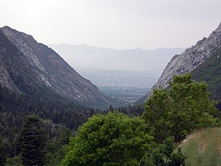
Little Cottonwood Canyon lies within the Wasatch-Cache National Forest along the eastern side of the Salt Lake Valley, roughly 15 miles from Salt Lake City, Utah. The canyon is part of Granite, a CDP and "Community Council" designated by Salt Lake County. The canyon is a glacial trough, carved by an alpine glacier during the last ice age, 15,000 to 25,000 years ago. A number of rare and endemic plant species are found in the canyon's Albion Basin. Mountain goats inhabit the surrounding mountains.

Yvon Chouinard is an American rock climber, environmentalist, and outdoor industry billionaire businessman. His company, Patagonia, is known for its environmental focus.

Mount Tom is a large and prominent peak near the city of Bishop in Inyo County of eastern California. It is in the Sierra Nevada and east of the Sierra Crest. The mountain is also in the John Muir Wilderness.

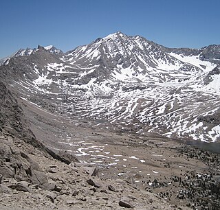
Mount Williamson, at 14,379 feet (4,383 m), is the second highest mountain in both the Sierra Nevada range and the state of California. It is the sixth highest peak in the contiguous United States.

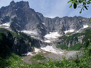
North Palisade is the third highest mountain in the Sierra Nevada range of California. It is the highest peak of the Palisades group of peaks in the central part of the range. It sports a small glacier and several highly prized rock climbing routes on its northeast side.

Goode Mountain is one of the major peaks of the North Cascades in the U.S. state of Washington. Named for topographer Richard U. Goode of the USGS, it is the highest peak located in North Cascades National Park, between the Skagit River and Lake Chelan. It is the fourth-highest non-volcanic peak in Washington, and the twelfth-highest summit overall.
Mount Tyndall is a peak in the Mount Whitney region of the Sierra Nevada in the U.S. state of California. It rises to 14,025 feet (4,275 m), and is the tenth highest peak in the state. The mountain was named in honor of the Irish scientist and mountaineer, John Tyndall.
Slesse Mountain, usually referred to as Mount Slesse, is a mountain just north of the US-Canada border, in the Cascade Mountains of British Columbia, near the town of Chilliwack. It is notable for its large, steep local relief. For example, its west face drops over 1,950 m (6,398 ft) to Slesse Creek in less than 3 km (2 mi). It is also famous for its huge Northeast Buttress; see the climbing notes below. The name means "fang" in the Halkomelem language. Notable nearby mountains include Mount Rexford and Canadian Border Peak in British Columbia, and American Border Peak, Mount Shuksan, and Mount Baker, all in the US state of Washington.

Fifty Classic Climbs Of North America is a climbing guidebook and history written by Steve Roper and Allen Steck. It is considered a classic piece of climbing literature, known to many climbers as simply "The Book", and has served as an inspiration for more recent climbing books, such as Mark Kroese's Fifty Favorite Climbs. Though much of the book's contents are now out of date, it is still recognized as a definitive text which goes beyond the traditional guidebook.

The Royal Arches Route is a technical climbing route in California's Yosemite Valley on the Royal Arches wall. The route is recognized in the historic climbing text Fifty Classic Climbs of North America. The route was first climbed Oct. 1936 by Ken Adam, Morgan Harris, K. Kenneth Davis. The route is moderate in difficulty and is frequently climbed. The first 4 pitches are along a west facing dihedral. At Pitch 5, the route turns north and ascends the main face along crack systems. Pitch 10 can be free climbed at 5.10b however, most climbers use a fixed rope to pendulum to a long ledge. At the end of Pitch 15, begins the bolted rappel route. It is 18 rappels to the Valley floor. Some climbers prefer to continue to "The Jungle" at the end of Pitch 16. Beyond The Jungle is a 5.4 slab and 4th Class scrambling to the Valley Rim. The descent is usually accomplished by traversing northeast to Washington Column and descending the exposed North Dome Gully.

Tom Frost was an American rock climber known for big wall climbing first ascents in Yosemite Valley. He was also a photographer and climbing equipment manufacturer.

Charles Marshall Pratt was an American rock climber known for big wall climbing first ascents in Yosemite Valley. He was also a long-time climbing instructor and mountain guide with Exum Mountain Guides in the Grand Tetons.
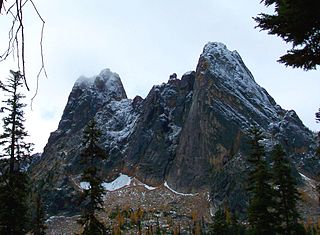
Liberty Bell Mountain is located in the North Cascades, approximately one mile south of Washington Pass on the North Cascades Highway. Liberty Bell is the most northern spire of the Liberty Bell Group, a group of spires which also includes Concord Tower, Lexington Tower, North Early Winters Spire, and South Early Winters Spire.

Chimney Rock is a mountain located in the Alpine Lakes Wilderness of the Central Cascade Range in western Washington, United States. The mountain has two main summits, a northeast spire and a central spire, as well as a minor south peak. Situated 10 miles NNE of Snoqualmie Pass, with its craggy appearance Chimney Rock is the most distinctive peak on the crest dividing the Snoqualmie River and Yakima River drainage areas. Lemah Mountain is to the south on the crest and Summit Chief Mountain to the northeast. Overcoat Peak is off the main ridge just to the north of Chimney Rock. The mountain has three glaciers: the Overcoat Glacier on the north, the Chimney Glacier on the south and east, and an unnamed glacier on the east side of the North Peak.
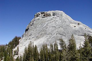
Pywiack Dome is a prominent 600 foot granite dome in Yosemite National Park, located 0.7 miles (1.1 km) north-east of Tenaya Lake, 4 miles (6.4 km) west of Tuolumne Meadows and 200 feet (61.0 m) from the Tioga Road. It is quite near Harlequin Dome, and North and South Whizz Domes are north.

Medlicott Dome is a prominent granite dome in Yosemite high country. It is located on the southeast side of Tioga Road, between Mariolumne Dome and Dozier Dome, near Pywiack Dome, the Cathedral lakes, Drug Dome, East Cottage Dome, West Cottage Dome, North and South Whizz Domes, and Fairview Dome. It is popular with climbers, hikers and backpackers due to relative ease of access and ascent, as well as scenic views of Yosemite.