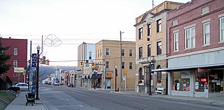
St. Marys is a city in Pleasants County, West Virginia, in the United States. The population was 1,860 at the 2010 census. It is the county seat of Pleasants County. St. Marys was established in 1849 by Alexander Creel, who is said to have had a vision of Mary while passing the townsite by boat on the Ohio River.
Catawba may refer to several things:

The National Register of Historic Places in the United States is a register including buildings, sites, structures, districts, and objects. The Register automatically includes all National Historic Landmarks as well as all historic areas administered by the U.S. National Park Service. Since its introduction in 1966, more than 90,000 separate listings have been added to the register.

Middle Island Creek is a river, 77 miles (124 km) long, in northwestern West Virginia in the United States. It is a tributary of the Ohio River, draining an area of 565 square miles (1,463 km²) on the unglaciated Allegheny Plateau. It was named by late 18th century pioneering travelers on the Ohio River, who noted the location of the Creek's mouth opposite Middle Island in the larger river.

Captina Island is an island on the Ohio River in Marshall County, West Virginia, USA. Powhatan Point, Ohio is located on the opposite shore from Captina Island. It lies at the southern end of Round Bottom with a stream-like channel separating the island from the West Virginia shore. Captina Island was once the place where watermelons were grown for the Marshall County Fair. It is part of the Ohio River Islands National Wildlife Refuge.
Broadback Island is an island in the Ohio River in Pleasants County, West Virginia. It is located opposite of the city of Belmont, West Virginia. Broadback Island is a part of the Ohio River Islands National Wildlife Refuge. The island is popular with bird watchers because it serves as a good place to scan for osprey and bald eagles. Along with First Brother Island closer to the Belmont shore, it is sometimes referred to as Second Brother Island.
Buckley Island is an island on the Ohio River in Wood County, West Virginia between Marietta, Ohio and Williamstown, West Virginia. The Interstate 77 bridge over the Ohio crosses the island's western portion. Throughout its history, Buckley Island has also been known as Kerrs Island, Duvall Island, and Meigs Island. The island is a part of the Ohio River Islands National Wildlife Refuge and can only be accessed by boat.
Eureka Island is an island on the Ohio River in Pleasants County, West Virginia southwest of the city of Belmont and Broadback Island. It's named for the nearby West Virginia community of Eureka. The island is a part of the Ohio River Islands National Wildlife Refuge.
Gallipolis Island is an island on the Ohio River along the bank at Gallipolis, Ohio and across from Mason County, West Virginia, USA.
Letart Island is a forested bar island on the Ohio River in Mason County, West Virginia. It is located between the towns of Letart, West Virginia and Letart Falls, Ohio. Letart Island is a part of the Ohio River Islands National Wildlife Refuge.
Lower Twin Island is a bar island on the Ohio River in the city of Wheeling, West Virginia. Lower Twin Island and its twin, Upper Twin Island, lie northwest of Wheeling's Warwood neighborhood. The island is a part of the Ohio River Islands National Wildlife Refuge.

Muskingum Island is a long narrow bar island on the Ohio River in Wood County, West Virginia between the towns of Moore Junction, Ohio and Boaz, West Virginia. The island is mostly covered in forests and contains a number of oil wells.
Williamson Island is a bar island on the Ohio River in Tyler County, West Virginia. It lies to the southwest of Paden City with Witten Towhead directly downstream. Along with Witten Towhead, Williamson Island is a part of the Ohio River Islands National Wildlife Refuge.
Paden Island is an island in Wetzel County, West Virginia on the Ohio River between Sardis, Ohio and Paden City, West Virginia. Paden Island is a part of the Ohio River Islands National Wildlife Refuge.

The Environment of West Virginia encompasses terrain and ecosystems ranging from plateaus to mountains. Most of West Virginia lies within the Appalachian mixed mesophytic forests ecoregion, while the higher elevations along the eastern border and in the panhandle lie within the Appalachian-Blue Ridge forests.
Grape Island may refer to
The Battle of Buffington Island, also known as the St. Georges Creek Skirmish, was an American Civil War engagement in Meigs County, Ohio, and Jackson County, West Virginia, on July 19, 1863, during Morgan's Raid. The largest battle in Ohio during the war, Buffington Island contributed to the capture of the famed Confederate cavalry raider, Brig. Gen. John Hunt Morgan, who was seeking to escape Union army pursuers across the Ohio River at a ford opposite Buffington Island.

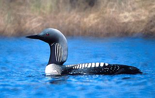
The Ohio River Islands National Wildlife Refuge (ORINWR) is a National Wildlife Refuge (NWR) in non-contiguous sites consisting of islands along 392 miles (631 km) of the Ohio River, primarily in the U.S. state of West Virginia. There are also a two of islands upstream in Beaver County, Pennsylvania and a two downstream in Lewis County, Kentucky. Going downstream, the refuge is currently located in parts of these counties: Beaver, Brooke, Ohio, Marshall, Wetzel, Tyler, Pleasants, Wood, Jackson, Mason, and Lewis. All counties are in West Virginia, with the exceptions of Beaver, which is in Pennsylvania, and Lewis, which is in Kentucky. The ORINWR was established in 1990 and consists of 3,354 acres (13.57 km2) of land and underwater habitat on 22 islands and four mainland properties. The refuge headquarters and visitors center is located in Williamstown, West Virginia. Prior to its establishment, West Virginia was the only state of the United States without a NWR.

Green Bottom Wildlife Management Area is located on former plantation lands of U.S. Congressman and Confederate General Albert G. Jenkins. The 1,096 acres (444 ha) in Cabell County and Mason County are located along the banks of the Ohio River about 16 miles (26 km) north of Huntington, West Virginia. The Green Bottom WMA land is a mixture of farmland, mixed hardwood forest, wetlands, and open water. The Jenkins Plantation Museum is located on Corps of Engineers land adjacent to the WMA. The museum is located in the original 1835 Green Bottom Plantation House, and is operated by the West Virginia Division of Culture and History.