Gravity spreading is a phenomenon in which a geological body[ clarification needed ] laterally extends and vertically contracts to reduce its gravitational potential energy. [1] It has been observed on many different scales, and at numerous locations on Earth, from rhyolite lava flows to passive margins. [2] [3] Additionally, gravity spreading is likely to have occurred on both Mars and Venus. [4] [5]
Historically, geologists have used the terms "gravity spreading" and "gravity gliding" interchangeably, or with little distinction. This article follows the convention of "Excursus on gravity gliding and gravity spreading" by D.D. Schultz-Ela, which defines gravity spreading as a lateral extension and vertical contraction, which thus must be applied to a non-rigid body. [1] Gravity gliding, however, is applied to a block that is not being deformed, and is therefore less common to observe. However, it can be difficult to distinguish between the two in real world scenarios, and often both occur simultaneously.
For gravity spreading to occur, a rock mass must be driven to deformation by gravity. As long as the center of gravity of the system descends, portions of the system may rise. Of course, a material normally resists such deformation. For gravity spreading to occur, the differential stress must be greater than that rock body's yield strength. [1] Gravity spreading can be thought of as a mound of molasses that spreads out, and gravity gliding can be imagined as a wooden block sliding down a slope.
Heart Mountain in Wyoming, United States, has been extensively studied, because Ordovician age carbonates (Madison Limestone), sit on top of a much younger (~50Ma) sedimentary formation (Willwood Formation). [6] It is now largely accepted that this juxtaposition of old rocks on top of young is the result of gravity spreading and gliding. Field observations, such as slight internal deformations of the older formation, indicate the gravity gliding and spreading of the Madison Limestones. [7] The specific details of the gravity spreading event are unclear, but it is thought that it was induced by the Laramide Orogeny, approximately 50 Ma. This caused the Madison Limestones to slide into the nearby Bighorn Basin, where it came to rest on top of the Willwood Formation. [6] The cause for block motion is debated, with numerous models to explain how such a large block could have moved tens of kilometers down a slope of less than 2°. [8] Models have ranged from lubrication by hydrothermal circulation, movement initiation from volcanogenic seismicity, to frictional heating dissociating CO2 from the carbonates, resulting in dramatically reduced friction. [8] The last of these theories is among the most recent, and by far the most spectacular. The authors envisage initially slow sliding, likely as the result of a volcanic eruption, until frictional heating of the carbonate rocks creates a supercritical CO2 layer, decreasing the friction tremendously. From this point, the sliding would occur rapidly, perhaps as high as 150 km/h. [8]
Gravity spreading in passive margins occurs when gravitational forces are strong enough to overcome the overburdens resistance to motion along its basal surface, and the internal strength. The gravitational forces are a function of the dip of the slope and the dip of the décollement layer. [3]
Rhyolite lava flows in northeastern New South Wales, Australia show recumbent folds that record a history of vertical shortening and lateral extension during deposition, consistent with what one would expect from gravity spreading. [2] This is the result of lava being displaced by new lava extruding from the vent.
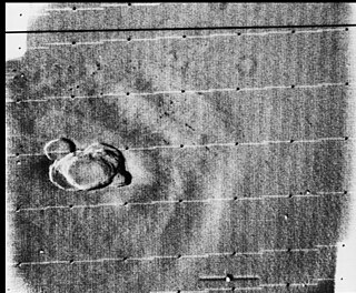
Satellite images of Mars have shown that the Thaumasia Plateau has large amounts of thrust faults, normal faults, and ridges. [4] This rifting has resulted in canyons, and compression at the front of the "mega-slide" has caused the ridges and thrust faults observed at low end of the region. To explain these faults and ridges, a four-stage model involving gravity spreading is used: [4]
It has been suggested that the "blocky" surface of Venus is the result of gravity spreading. This is thought because of flow-like structures correlated with topography, and as well as potential regions of thermal uplift, and has been reinforced by terrestrial analogues. [5]

Olympus Mons is a large shield volcano on Mars. It is over 21.9 km high as measured by the Mars Orbiter Laser Altimeter (MOLA), about 2.5 times the elevation of Mount Everest above sea level. It is Mars's tallest volcano, its tallest planetary mountain, and is approximately tied with Rheasilvia on Vesta as the tallest mountain currently discovered in the Solar System. It is associated with the volcanic region of Tharsis Montes. It last erupted 25 million years ago.
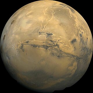
Valles Marineris is a system of canyons that runs along the Martian surface east of the Tharsis region. At more than 4,000 km (2,500 mi) long, 200 km (120 mi) wide and up to 7 km (23,000 ft) deep, Valles Marineris is the largest canyon in the Solar System.

Tharsis is a vast volcanic plateau centered near the equator in the western hemisphere of Mars. The region is home to the largest volcanoes in the Solar System, including the three enormous shield volcanoes Arsia Mons, Pavonis Mons, and Ascraeus Mons, which are collectively known as the Tharsis Montes. The tallest volcano on the planet, Olympus Mons, is often associated with the Tharsis region but is actually located off the western edge of the plateau. The name Tharsis is the Greco-Latin transliteration of the biblical Tarshish, the land at the western extremity of the known world.

Alba Mons is a volcano located in the northern Tharsis region of the planet Mars. It is the biggest volcano on Mars in terms of surface area, with volcanic flow fields that extend for at least 1,350 km (840 mi) from its summit. Although the volcano has a span comparable to that of the United States, it reaches an elevation of only 6.8 km (22,000 ft) at its highest point. This is about one-third the height of Olympus Mons, the tallest volcano on the planet. The flanks of Alba Mons have very gentle slopes. The average slope along the volcano's northern flank is 0.5°, which is over five times lower than the slopes on the other large Tharsis volcanoes. In broad profile, Alba Mons resembles a vast but barely raised welt on the planet's surface. It is a unique volcanic structure with no counterpart on Earth or elsewhere on Mars.

A joint is a break (fracture) of natural origin in a layer or body of rock that lacks visible or measurable movement parallel to the surface (plane) of the fracture. Although joints can occur singly, they most frequently appear as joint sets and systems. A joint set is a family of parallel, evenly spaced joints that can be identified through mapping and analysis of their orientations, spacing, and physical properties. A joint system consists of two or more intersecting joint sets.

A passive margin is the transition between oceanic and continental lithosphere that is not an active plate margin. A passive margin forms by sedimentation above an ancient rift, now marked by transitional lithosphere. Continental rifting forms new ocean basins. Eventually the continental rift forms a mid-ocean ridge and the locus of extension moves away from the continent-ocean boundary. The transition between the continental and oceanic lithosphere that was originally formed by rifting is known as a passive margin.

Heart Mountain is an 8,123-foot (2,476 m) klippe just north of Cody in the U.S. state of Wyoming, rising from the floor of the Bighorn Basin. The mountain is composed of limestone and dolomite of Ordovician through Mississippian age, but it rests on the Willwood Formation, rocks that are about 55 million years old—the rocks on the summit of Heart Mountain are almost 300 million years older than the rocks at the base. For over one hundred years, geologists have tried to understand how these older rocks came to rest on much younger strata.

Décollement is a gliding plane between two rock masses, also known as a basal detachment fault. Décollements are a deformational structure, resulting in independent styles of deformation in the rocks above and below the fault. They are associated with both compressional settings and extensional settings.

A rift zone is a feature of some volcanoes, especially shield volcanoes, in which a set of linear cracks develops in a volcanic edifice, typically forming into two or three well-defined regions along the flanks of the vent. Believed to be primarily caused by internal and gravitational stresses generated by magma emplacement within and across various regions of the volcano, rift zones allow the intrusion of magmatic dykes into the slopes of the volcano itself. The addition of these magmatic materials usually contributes to the further rifting of the slope, in addition to generating fissure eruptions from those dykes that reach the surface. It is the grouping of these fissures, and the dykes that feed them, that serves to delineate where and whether a rift zone is to be defined. The accumulated lava of repeated eruptions from rift zones along with the endogenous growth created by magma intrusions causes these volcanoes to have an elongated shape. Perhaps the best example of this is Mauna Loa, which in Hawaiian means "long mountain", and which features two very well defined rift zones extending tens of kilometers outward from the central vent.
This glossary of geology is a list of definitions of terms and concepts relevant to geology, its sub-disciplines, and related fields. For other terms related to the Earth sciences, see Glossary of geography terms.
Volcanic activity, or volcanism, has played a significant role in the geologic evolution of Mars. Scientists have known since the Mariner 9 mission in 1972 that volcanic features cover large portions of the Martian surface. These features include extensive lava flows, vast lava plains, and the largest known volcanoes in the Solar System. Martian volcanic features range in age from Noachian to late Amazonian, indicating that the planet has been volcanically active throughout its history, and some speculate it probably still is so today. Both Mars and Earth are large, differentiated planets built from similar chondritic materials. Many of the same magmatic processes that occur on Earth also occurred on Mars, and both planets are similar enough compositionally that the same names can be applied to their igneous rocks.
Volcanic passive margins (VPM) and non-volcanic passive margins are the two forms of transitional crust that lie beneath passive continental margins that occur on Earth as the result of the formation of ocean basins via continental rifting. Initiation of igneous processes associated with volcanic passive margins occurs before and/or during the rifting process depending on the cause of rifting. There are two accepted models for VPM formation: hotspots/mantle plumes and slab pull. Both result in large, quick lava flows over a relatively short period of geologic time. VPM's progress further as cooling and subsidence begins as the margins give way to formation of normal oceanic crust from the widening rifts.

Tharsis Tholus is an intermediate-sized shield volcano located in the eastern Tharsis region of the planet Mars. The volcano was discovered by the Mariner 9 spacecraft in 1972 and originally given the informal name Volcano 7. In 1973, the International Astronomical Union (IAU) officially designated it Tharsis Tholus. In planetary geology, tholus is the term for a small domical mountain, usually a volcano.

Lava is molten or partially molten rock (magma) that has been expelled from the interior of a terrestrial planet or a moon onto its surface. Lava may be erupted at a volcano or through a fracture in the crust, on land or underwater, usually at temperatures from 800 to 1,200 °C. The volcanic rock resulting from subsequent cooling is also often called lava.

The Tharsis quadrangle is one of a series of 30 quadrangle maps of Mars used by the United States Geological Survey (USGS) Astrogeology Research Program. The Tharsis quadrangle is also referred to as MC-9 . The name Tharsis refers to a land mentioned in the Bible. It may be at the location of the old town of Tartessus at the mouth of Guadalquivir.

The Ceraunius Fossae are a set of fractures in the northern Tharsis region of Mars. They lie directly south of the large volcano Alba Mons and consist of numerous parallel faults and tension cracks that deform the ancient highland crust. In places, younger lava flows cover the fractured terrain, dividing it into several large patches or islands. They are found in the Tharsis quadrangle.
The salt tectonics off the Louisiana gulf coast can be explained through two possible methods. The first method attributes spreading of the salt because of sedimentary loading while the second method points to slope instability as the primary cause of gliding of the salt. The first method results in the formation of growth faults in the overlying sediment. Growth faults are normal faults that occur simultaneously with sedimentation, causing them to have thicker sediment layers on the downthrown sides of the faults. In the second method both the salt and the sediment are moving, making it more likely to migrate.
The Troodos Ophiolite on the island of Cyprus represents a Late Cretaceous spreading axis that has since been uplifted due to its positioning on the overriding Anatolian plate at the Cyprus arc and ongoing subduction to the south of the Eratosthenes Seamount.
The Angola Basin is located along the West African South Atlantic Margin which extends from Cameroon to Angola. It is characterized as a passive margin that began spreading in the south and then continued upwards throughout the basin. This basin formed during the initial breakup of the supercontinent Pangaea during the early Cretaceous, creating the Atlantic Ocean and causing the formation of the Angola, Cape, and Argentine basins. It is often separated into two units: the Lower Congo Basin, which lies in the northern region and the Kwanza Basin which is in the southern part of the Angola margin. The Angola Basin is famous for its "Aptian Salt Basins," a thick layer of evaporites that has influenced topography of the basin since its deposition and acts as an important petroleum reservoir.

The geology of Guam formed as a result of mafic, felsic and intermediate composition volcanic rocks erupting below the ocean, building up the base of the island in the Eocene, between 33.9 and 56 million years ago. The island emerged above the water in the Eocene, although the volcanic crater collapsed. A second volcanic crater formed on the south of the island in the Oligocene and Miocene. In the shallow water, numerous limestone formations took shape, with thick alternating layers of volcanic material. The second crater collapsed and Guam went through a period in which it was almost entirely submerged, resembling a swampy atoll, until structural deformation slowly uplifted different parts of the island to their present topography. The process of uplift led to widespread erosion and clay formation, as well as the deposition of different types of limestone, reflecting different water depths.