
Pineland is an unincorporated community and census-designated place (CDP) on Pine Island in Lee County, Florida, United States. The population was 407 at the 2010 census. It is part of the Cape Coral-Fort Myers, Florida Metropolitan Statistical Area.

Pine Island Sound is located in Lee County, Florida, lying between Pine Island and the barrier islands of Sanibel Island, Captiva Island, North Captiva Island and Cayo Costa, which separate the Sound from the Gulf of Mexico. The Sound connects to Gasparilla Sound and Charlotte Harbor to the north, and to San Carlos Bay and the Caloosahatchee River to the south. The Sound is conterminous with the Pine Island Sound Aquatic Preserve, which was established in 1970 and consists of 54,000 acres (220 km2) of submerged land. Important habitats in the Sound include mangroves, seagrasses, salt marshes, oyster communities, tidal flats and sponge beds. All animals in and around Pine Island sound, including mollusks, fish, birds and mammals, are affected by periodic outbreaks of red tide. The Sound is relatively shallow in many locations, and boaters are cautioned to utilize up-to-date charts and tide tables.

George L. Smith State Park is a 1,634-acre (6.61 km2) Georgia state park located in Emanuel County. The park is named after George L. Smith, a former speaker of the Georgia House of Representatives and Emanuel County native. Attractions include a grist mill, covered bridge, and the dam of the Parrish Mill. The park's location on a 412-acre (1.67 km2) mill pond dotted with many cypress trees makes it a destination for anglers and canoeists. The moderately-sized state park is in a remote location, making it an attraction for bird watchers and naturalists. Rare birds in residence include the great blue heron and the white ibis.
The Myakkahatchee Creek is a small stream located near the city of North Port in Sarasota County, Florida. It is a tributary of the Myakka River.
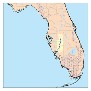
The Peace River is a river in the southwestern part of the Florida peninsula, in the U.S.A. It originates at the juncture of Saddle Creek and Peace Creek northeast of Bartow in Polk County and flows south through Fort Meade Hardee County to Arcadia in DeSoto County and then southwest into the Charlotte Harbor estuary at Punta Gorda in Charlotte County. It is 106 miles (171 km) long and has a drainage basin of 1,367 square miles (3,540 km2). U.S. Highway 17 runs near and somewhat parallel to the river for much of its course. The river was called Rio de la Paz on 16th century Spanish charts. It appeared as Peas Creek or Pease Creek on later maps. The Creek Indians call it Talakchopcohatchee, River of Long Peas. Other cities along the Peace River include Fort Meade, Wauchula and Zolfo Springs.
Rock Springs Run State Reserve is a 14,000-acre (5,700 ha) State Park in the U.S. state of Florida. The main entrance is located about 30 miles (48 km) north of Orlando in Sorrento, 3 miles (4.8 km) west of the Wekiva River bridge on State Road 46 and extends into Orange and Seminole Counties to the south. The park contains a number of Indian mounds, pine flatwoods, swamps and artesian springs, and a number of creeks and rivers. Among them are Seminole Creek, Wekiwa Springs Run, Rock Springs Run, and the Wekiva River.

The Shiawassee River in the U.S. state of Michigan drains an area of 1,201 square miles (3,110 km2) within Oakland, Genesee, Livingston, Shiawassee, Midland and Saginaw counties. It flows in a generally northerly direction for about 110 miles (180 km) from its source to its confluence with the Tittabawassee River creating the Saginaw River, which drains into the Saginaw Bay of Lake Huron.

The Santa Fe River is a 75-mile (121 km) river in northern Florida. The watershed of the river is approximately 1,380 square miles (3,574 km2) and spreads across southern Columbia, southern Suwannee, western Bradford, far southern Baker, Union, northern and eastern Gilchrist, and northern Alachua counties. The headwaters of the river are Lake Santa Fe, near Keystone Heights. The Santa Fe River is usually a slow-flowing river. This slow speed, combined with the abundant leaf-drop from nearby trees, especially Bald Cypress, leads to a very dark-brown river due to dissolved tannins.

The Blackwater River of Florida is a 56.6-mile-long (91.1 km) river rising in southern Alabama and flowing through the Florida Panhandle to the Gulf of Mexico. The river enters Florida in Okaloosa County and flows through Santa Rosa County to Blackwater Bay, an arm of Pensacola Bay. The river passes through Blackwater River State Forest and Blackwater River State Park. Milton, the county seat of Santa Rosa County, is located on the river.

The Rocky River is a 95-mile-long (153 km) river in the Piedmont region of North Carolina. It begins in Iredell County near Mooresville and flows south into Cabarrus County, where it is the principal waterway in the county. The river continues southeastward to form the line between Stanly, Union, and Anson counties. It empties into the Pee Dee River just below Norwood, North Carolina at the junction of Stanly, Montgomery, Anson, and Richmond counties, at the foot of the Uwharrie Mountains.
The Greenways Alliance of Rhode Island was a non-profit organization dedicated to advocacy for Rhode Island's bike paths, trails and greenspaces. It also served as the state committee of the East Coast Greenway. In Spring 2010, GARI merged with the Providence Bicycle Coalition to become the Rhode Island Bicycle Coalition.
The Tip of The Thumb Heritage Water Trails is a nonprofit citizens organization working with the Huron County Parks to establish and maintain a water trail along Michigan's Lake Huron's shoreline. It is dependent on public support for its existence and growth. The Water Trail, which is best utilized via sea kayaks by people who have had proper sea kayaking instruction, consists of camp sites and rest areas spaced out along the shore. The trail is still being developed, so there are several large sections with no public landing sites.

Billy's Creek is a creek in Fort Myers, Florida. It is a tributary of the Caloosahatchee River and contains mangrove vegetation. The creek was named after the Seminole chief Billy Bowlegs who was forced to surrender there by United States forces in 1858. Billy's Creek has its beginnings as meandering water from a canal and is unique in that it is a scenic urban waterway and part of the Calusa Blueway. Joint efforts to improve water quality from various government agencies allowed the construction of the Billy's Creek Filter Marsh and adjacent nature park. This waterway is maintained by the Friends of Billy's Creek, a volunteer group in Lee County.
The Tennessee River Blueway is a 50-mile (80 km) section of the Tennessee River that flows between the Chickamauga Dam and the Nickajack Dam and through downtown Chattanooga, Tennessee and the Tennessee River Gorge. The city of Chattanooga and the Tennessee River Gorge Trust along with other agencies have designated the section of river as a blueway for a canoe and kayak paddlers to travel and enjoy. Along the way, travelers will find primitive camping areas next to the river, a mix of museums, restaurants, activities, entertainment and natural attractions. From there, the Blueway meanders its way to quieter places like Williams Island State Archaeological Park. Williams Island divides the river channel with a 450-acre (1.8 km2) tract of land inhabited only by wildlife. From about 1000 to 1650, this area was home to several Native American tribes. It is now managed by the Tennessee River Gorge Trust and popular with birders and naturalists, as well as archaeologists. Then next of course is the 26-mile (42 km) stretch of the Tennessee River Gorge, a steep canyon formed by the Tennessee River. The scenic terrain of the Tennessee River Gorge creates a unique diversity of land forms. The land provides habitats for more than a thousand varieties of plants, ferns, trees, grasses and flowers as well as a wildlife population. Many of these are rare or endangered species such as the mountain skullcap. Dozens of archaeological sites bear evidence of man's presence in the Gorge for at least 10,000 years. There is a secluded spot where you can see Nickajack Cave from the water. Tennessee Valley Authority biologists monitor its bat population and encourage the public to "bat watch." There is no cave access, but canoeists and kayakers can drift at twilight with binoculars in hand to observe the comings and goings of these small but busy nocturnal creatures. There are many camping options and points of interest along the blueway.
Eagle Point Park encompasses 15 acres (61,000 m2) of a 600-acre (2.4 km2) coastal nature preserve in Pasco County, Florida west of US 19 and includes trails, a canoe and kayak launch dock, playground equipment, three fishing piers, and picnic shelters. It opened in 2010 after six years in planning and construction following the property's being purchased in order to forestall development. Pasco Palms Preserve is adjacent to the park.
The Imperial River is a river in southwest Florida in the United States. It is fed by the Kehl Canal and marshland at 26°22′16″N81°41′23″W, just east of the city limits of Bonita Springs in unincorporated southwest Lee County. It is approximately 9.3 miles (15.0 km) long, from its headwaters just east of I-75 in the Flint Pen Strand, through downtown Bonita Springs and to its mouth at the north end of Fishtrap Bay, near the southern end of Estero Bay. It was originally named Surveyors Creek before the city was developed. The river is part of The Great Calusa Blueway.
The Un-Road Trip is an American reality television series featuring Boaz Frankel, a Portland, Oregon resident, as he travels 12,000 miles across North America using 101 non-gas powered modes of transportation. Most of the show was filmed over a ten-week period beginning in April 2009. It was first aired as a weekly series on Halogen TV, beginning on April 22, 2011.
Matanzas Pass Preserve is a 60-acre (24 ha) area of protected land in Lee County, Florida, located one mile south of Matanzas Pass Bridge off Estero Boulevard on Estero Island in Fort Myers Beach. The preserve has trails and a paddle craft landing. It is along the Great Calusa Blueway Paddling Trail.
Lemon Bay is a long, narrow and shallow body of water covering 8,000 acres in Charlotte County, Florida and Sarasota County, Florida. It is protected as the Lemon Bay Aquatic Preserve, designated in 1986. It is one of five Charlotte Harbor Aquatic Preserves. The bay is fed by one Gulf pass, Stump Pass, and seven tributaries and includes areas of mangrove, marsh grass, and seagrass. It provides habitat for bird, invertebrate and fish species and offers fishing, kayaking, birding, wading and beachcombing opportunities.
The Palatlakaha River is a river in Lake County, Florida. It forms the principal headwater of the Ocklawaha River, a tributary of St. Johns River. The source of the Palatlakaha River is at Lake Louisa, itself fed from the Green Swamp by two streams known as Big Creek and Little Creek.
