
Homerton is an area in London, England, in the London Borough of Hackney. It is bordered to the west by Hackney Central, to the north by Lower Clapton, in the east by Hackney Wick, Leyton and by South Hackney to the south. In 2019, it had a population of 14,658 people. In terms of ethnicity it was 43.9% White, 33.0% Black, 10.9% Asian and 7.8% Mixed. It covered an area of 0.830 sq kilometres. Homerton ward on Hackney Borough Council is currently represented by three Labour councillors. There are fifty listed buildings located within the boundaries of the ward.

Buckingham is a market town in north Buckinghamshire, England, close to the borders of Northamptonshire and Oxfordshire, which had a population of 12,890 at the 2011 Census. The town lies approximately 12 miles (19 km) west of Central Milton Keynes, 19 miles (31 km) south-east of Banbury, and 24 miles (39 km) north-east of Oxford.

Sowerby is a village, electoral ward and civil parish in the Hambleton District of North Yorkshire, England immediately south of the neighbouring market town of Thirsk. Although the boundary between the two parishes runs very close to Thirsk town centre, the village retains its own identity and has a separate Parish Council. The author James Herriot lived in the village.

Watford is a town and borough in Hertfordshire, England, 15 mi (24 km) north-west of Central London, on the banks of the River Colne.

Little Clarendon Street is a short shopping street in northwest Oxford, England. It runs east-west between the south end of Woodstock Road opposite St Giles' Church to the east, Somerville College to the north and Walton Street to the west. One of the three principal streets in North Oxford off the Woodstock Road, the shops and cafés located there are considered bohemian; the other two streets are North Parade and South Parade. Occasionally nicknamed Little Trendy Street, its reputation was already apparent in the 1960s.

Deddington is a civil parish and small town in Oxfordshire about 6 miles (10 km) south of Banbury. The parish includes two hamlets: Clifton and Hempton. The 2011 Census recorded the parish's population as 2,146. Deddington is a small settlement but has a commercial centre including a market place, which hosts a popular monthly farmer’s market. It has been a market town probably since the 12th century. One of the Hundred Rolls of King Edward I from 1275–76 records Deddington as a borough. It has a deli, coffee shop, restaurant, three pubs and a town hall. Its football team is called Deddington Town FC.

Jericho is an historic suburb of the English city of Oxford. It consists of the streets bounded by the Oxford Canal, Worcester College, Walton Street and Walton Well Road. Located outside the old city wall, it was originally a place for travellers to rest if they had reached the city after the gates had closed. The name Jericho may have been adopted to signify this 'remote place' outside the wall. As of February 2021, the population of Jericho and Osney wards was 6,995.

Broad Street is a wide street in central Oxford, England, just north of the former city wall. The street is known for its bookshops, including the original Blackwell's bookshop at number 50, located here due to the University of Oxford. Among residents, the street is traditionally known as The Broad.

Walton Street is on the eastern edge of the Jericho district of central Oxford, England.

St Sepulchre's Cemetery is a cemetery located on Walton Street, Jericho, central Oxford, England.

New Inn Hall Street is a street in central Oxford, England, and is one of Oxford's oldest streets. It is a shopping street running north–south parallel and to the west of Cornmarket Street, with George Street to the north and Bonn Square at the west end of Queen Street to the south. St Michael's Street leads off the street to the east near the northern end. Shoe Lane to the east leads to the Clarendon Centre, a modern shopping centre.

Thomas Combe was a British printer, publisher and patron of the arts. He was 'Printer to the University' at Oxford University Press, and was also a founder and benefactor of St Barnabas Church, near the Press in Jericho and close to Oxford Canal.
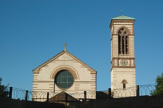
St Barnabas Church is a Church of England parish church in Jericho, central Oxford, England, located close to the Oxford Canal.
The Eagle Ironworks was an ironworks owned by W. Lucy & Co. on the Oxford Canal in Jericho, Oxford, England. William Carter founded the works in 1812 with a shop in the High Street and moved it to its site beside the canal in 1825. It was on Walton Well Road at the northern end of Walton Street and backed onto St Sepulchre's Cemetery. The works ceased production in 2005, was demolished in 2007 and has since been redeveloped, mainly with apartments.

St Thomas the Martyr Church is a Church of England parish church of the Anglo-Catholic tradition, in Oxford, England, near Oxford railway station in Osney. It is located between Becket Street to the west and Hollybush Row to the east, with St Thomas Street opposite.

Jericho Health Centre is a health centre on Walton Street in Oxford, England. It is named after the district of Jericho, just northwest of central Oxford. It is part of the United Kingdom's National Health Service (NHS).

Walton Well Road is a road, about 400 metres long, near the centre of Oxford, England. It provides a link from central Oxford to Port Meadow.
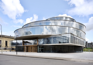
The Blavatnik School of Government is a school of public policy founded in 2010 at the University of Oxford in England. The School was founded following a £75 million donation from a business magnate Len Blavatnik, supported by £26 million from the University of Oxford. It is part of Oxford's Social Sciences Division, which aims to train current and future leaders in the practice of government.
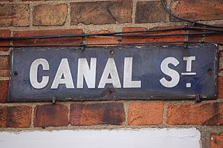
Canal Street is a residential street in Jericho, an inner suburb of Oxford, England, northwest of the city centre.

The octagonal Chapel of St Mary at Smith Gate is a former chapel in Oxford, England, now part of Hertford College. It is located on Catte Street, opposite the Clarendon Building.


